
Future Research and Trends
Enroll to start learning
You’ve not yet enrolled in this course. Please enroll for free to listen to audio lessons, classroom podcasts and take practice test.
Interactive Audio Lesson
Listen to a student-teacher conversation explaining the topic in a relatable way.
Real-Time Ground Motion Prediction
🔒 Unlock Audio Lesson
Sign up and enroll to listen to this audio lesson

Today, we're diving into the concept of real-time ground motion prediction. Can anyone explain why real-time predictions are important for earthquake early warning systems?

They're important because they can help people react quickly, like evacuating buildings when an earthquake is predicted.
Exactly! The quicker we can predict ground shaking, the more lives we can save. Now, can anyone tell me what technologies are making this real-time prediction possible?

I think AI and machine learning are playing a big part in pattern recognition, right?
Yes! AI can analyze data faster than humans to identify wave patterns. Remember the acronym 'SMART' to recall the role of sensors, machines, AI, real-time data, and technology in enhancing predictions.

So, SMART helps us remember how technology aids in earthquake prediction?
Exactly! We need to be quick and effective in grounding our strategies using technology.
In summary, real-time ground motion prediction integrates AI and machine learning to enhance our earthquake response, making it crucial for disaster preparedness.
Advanced Geophysical Imaging
🔒 Unlock Audio Lesson
Sign up and enroll to listen to this audio lesson

Let's move on to advanced geophysical imaging. What are some benefits of high-resolution imaging for earthquake hazard assessment?

It helps us locate wave velocity anomalies, which can show how seismic waves might behave in different soil types.
Correct! By understanding where weaknesses exist, we can improve our designs and emergency plans. Who can explain ambient vibration testing?
Isn't it a way to measure vibrations from natural sources to see how they affect structures?
That's right! Often, such tests help estimate Rayleigh wave dispersion. Remember the phrase 'Test to Protect' for this concept, indicating that testing can lead to better protection strategies.
So testing our environments helps us prepare for earthquakes?
Exactly! In summary, advanced geophysical imaging techniques create better insights into subsurface conditions, allowing more effective disaster preparedness.
Resilient Design Strategies
🔒 Unlock Audio Lesson
Sign up and enroll to listen to this audio lesson
Now, let’s talk about resilient design strategies. What types of systems do you think could be used to withstand seismic waves?
Wave-resistant foundations could help buildings absorb shock.
Good point! These foundations are designed to reduce damage. What about smart materials?
Smart materials could change their properties based on the seismic activity, right?
Absolutely! They adapt dynamically. Let's remember 'SMART MATERIALS' as a shortcut to recall their properties: 'Sensory Material Adapting Real-time to Technology in Earthquakes'.
So, these materials could help us respond to the earthquake's impact better?
Exactly! In summary, resilient design strategies like wave-resistant foundations and smart materials are vital in preparing structures to better withstand seismic forces.
Introduction & Overview
Read summaries of the section's main ideas at different levels of detail.
Quick Overview
Standard
The future of earthquake engineering emphasizes the development of real-time ground motion prediction systems using AI, advanced geophysical imaging techniques for better subsurface analysis, and resilient design strategies that integrate technology to enhance structural responses to seismic forces.
Detailed
Future Research and Trends in Earthquake Engineering
This section discusses significant trends and future research directions in earthquake engineering, outlining key technological advancements and methodologies expected to improve our understanding and management of seismic hazards.
26.15.1 Real-Time Ground Motion Prediction
This part focuses on the importance of real-time modeling of Rayleigh wavefront propagation, particularly in the context of earthquake early warning systems (EEWS). The integration of artificial intelligence (AI) and machine learning is highlighted as a critical tool for recognizing wave patterns, allowing for faster and more accurate predictions of seismic events.
26.15.2 Advanced Geophysical Imaging
Innovations in high-resolution subsurface imaging techniques are discussed, emphasizing their role in identifying wave velocity anomalies which can significantly inform risk assessments. The section also notes ambient vibration testing and passive seismic arrays as emerging methods to estimate Rayleigh wave dispersion, improving our understanding of how these waves interact with various geological conditions.
26.15.3 Resilient Design Strategies
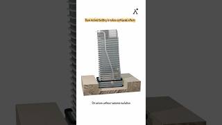
The introduction of wave-resistant foundation systems shows promise in enhancing building resilience against seismic waves. Moreover, the integration of smart materials and sensors is positioned as a dynamic solution to detect and respond to S and Rayleigh wave effects in real-time, thus enhancing structural performance during earthquakes.
Youtube Videos


Audio Book
Dive deep into the subject with an immersive audiobook experience.
Real-Time Ground Motion Prediction
Chapter 1 of 3
🔒 Unlock Audio Chapter
Sign up and enroll to access the full audio experience
Chapter Content
• Real-time modeling of Rayleigh wavefront propagation for earthquake early warning systems (EEWS).
• Use of AI and machine learning for wave pattern recognition.
Detailed Explanation
This chunk discusses the integration of advanced technologies for predicting earthquake impacts through real-time modeling. It suggests that Rayleigh waves, which are surface waves, can be modeled in real-time to provide alerts before the shaking starts. This is crucial for minimizing damage and ensuring safety during an earthquake. Additionally, artificial intelligence (AI) and machine learning can analyze seismic data to recognize patterns in wave propagation, potentially helping to predict when and where seismic activity may occur.
Examples & Analogies
Imagine you're at home, and a friend texts you about a rainstorm approaching your area based on an app. This real-time data allows you to grab an umbrella and stay dry. In the same way, if earthquake early warning systems could provide real-time updates on seismic waves, it would give people crucial time to take cover or evacuate.
Advanced Geophysical Imaging
Chapter 2 of 3
🔒 Unlock Audio Chapter
Sign up and enroll to access the full audio experience
Chapter Content
• High-resolution subsurface imaging to capture wave velocity anomalies.
• Use of ambient vibration testing and passive seismic arrays to estimate Rayleigh wave dispersion.
Detailed Explanation
This chunk focuses on improving techniques for visualizing the Earth's underground structure. High-resolution imaging refers to advanced methods that can identify unusual patterns in wave velocity, which can indicate different geological formations or weaknesses in the ground. Ambient vibration testing involves measuring natural vibrations from everyday activities or environmental factors. By placing sensors to capture these vibrations, scientists can infer information about wave dispersion – how different frequencies of waves travel through the Earth. This technique helps to obtain a clearer picture of subsurface characteristics, which is vital for construction and safety planning.
Examples & Analogies
Think about using a powerful camera to take a picture of a beautiful mountain scene. The high-resolution image captures every detail, from the snow on the peaks to individual trees in the valley. Similarly, high-resolution subsurface imaging helps scientists 'see' what's below the surface of the Earth, allowing them to understand better how waves will behave in different geological conditions.
Resilient Design Strategies
Chapter 3 of 3
🔒 Unlock Audio Chapter
Sign up and enroll to access the full audio experience
Chapter Content
• Development of wave-resistant foundation systems.
• Integration of smart materials and sensors to detect and respond to S and Rayleigh wave effects dynamically.
Detailed Explanation
This chunk addresses innovative approaches to designing buildings and infrastructure that can withstand seismic events. Wave-resistant foundation systems are specially engineered to absorb and mitigate the impact of seismic waves, reducing potential damage. Furthermore, the use of smart materials includes materials that can sense stress or movement and adapt accordingly. By integrating sensors into structures, engineers can monitor the effects of S-waves and Rayleigh waves in real-time and make necessary adjustments to maintain safety and stability.
Examples & Analogies
Consider a smartphone that can adjust its screen brightness based on how bright the environment is. Just like that, waves-resistant building designs can adjust their structure in response to seismic activity, ensuring safety during earthquakes. This dynamic approach is similar to how a well-trained athlete adapts their movements based on their environment to avoid injury or fall.
Key Concepts
-
Real-Time Ground Motion Prediction: Importance of using AI in early warning systems.
-
Advanced Geophysical Imaging: Techniques to improve understanding of subsurface conditions.
-
Resilient Design Strategies: Innovative approaches to enhance building performance during seismic events.
Examples & Applications
The integration of AI in earthquake early warning systems enhances the accuracy of predictions and helps save lives.
High-resolution imaging techniques have enabled engineers to identify weak spots in soil, thus improving construction standards in seismic areas.
Wave-resistant foundations are being developed that can adapt to seismic waves, significantly reducing potential structural damage.
Memory Aids
Interactive tools to help you remember key concepts
Rhymes
In a quake, the smart and bright, build to sway and hold on tight.
Stories
Imagine a city where buildings dance with the waves, thanks to smart materials that sense the tremors and move gracefully to protect themselves.
Memory Tools
Remember 'SMART' to recall: Sensors, Machines, AI, Real-time data, Technology.
Acronyms
For wave-resistant design, think 'WAVE'
Withstand
Adapt
Verify
Enhance.
Flash Cards
Glossary
- AI (Artificial Intelligence)
The simulation of human intelligence processes by machines, especially computer systems, used here for wave pattern recognition.
- Rayleigh Waves
Surface seismic waves that roll along the ground and produce both vertical and horizontal ground motion.
- Geophysical Imaging
Techniques used to visualize subsurface attributes and conditions, critical for understanding seismic wave velocity.
- Smart Materials
Materials engineered to respond dynamically to environmental changes, including seismic activity.
Reference links
Supplementary resources to enhance your learning experience.