
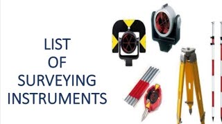
Equipment Used in Construction Surveys
Enroll to start learning
You’ve not yet enrolled in this course. Please enroll for free to listen to audio lessons, classroom podcasts and take practice test.
Interactive Audio Lesson
Listen to a student-teacher conversation explaining the topic in a relatable way.
Conventional Instruments
🔒 Unlock Audio Lesson
Sign up and enroll to listen to this audio lesson

Today, we’re going to explore conventional instruments used in construction surveys. Can anyone tell me what some of these instruments are?

Is it the dumpy level and theodolite?
Absolutely! The dumpy level is used for leveling and theodolites for measuring angles. Remember, both are essential for establishing reference points.

What about chains and tape? What do they do?
Good question! Chains and tapes are fundamental for manual distance measurement, providing baseline data for more complex surveys. Think of them as the basic building blocks of surveying.

So they are still relevant even with modern technology?
Yes! They are often used in conjunction with modern tools to ensure accuracy. Remember: Basics build brilliance!

How do we know which instrument to use when?
It depends on the task’s requirements. For quick elevation checks, a dumpy level works best, while for angle measurement, a theodolite is ideal.
Let’s summarize: Conventional tools like dumpy levels and theodolites complement each other and are still vital for accurate surveying. Always consider the task when choosing your tool.
Modern Survey Instruments
🔒 Unlock Audio Lesson
Sign up and enroll to listen to this audio lesson

Now, let’s look at modern survey instruments. Who can name one?
Is a total station considered a modern instrument?
Right! Total stations combine electronic measurements with data logging capabilities. They streamline the surveying process.
And what about GNSS? How does it work?
GNSS, or Global Navigation Satellite Systems, allows for precise location tracking. It can operate in RTK (Real-Time Kinematic) mode, achieving centimeter-level accuracy. Great for layout and alignment!
Does that mean it replaces traditional methods?
Not entirely! While it enhances precision, traditional methods are still important for verification. Always cross-reference!
How do drones fit into all this?
Drones enable large-scale, aerial surveys, capturing data rapidly. They are fantastic for progress monitoring as they provide a unique perspective on construction sites.
So to sum up: Modern instruments like total stations, GNSS receivers, and drones greatly enhance surveying, offering precision and efficiency.
Introduction & Overview
Read summaries of the section's main ideas at different levels of detail.
Quick Overview
Standard
The section highlights both conventional survey tools, such as dumpy levels and theodolites, and modern equipment like total stations, GNSS receivers, drones, and laser scanners. These tools are essential for ensuring precise measurements and effective management of construction projects.
Detailed
Equipment Used in Construction Surveys
Construction surveys are crucial for accurate placement and construction of structures. To perform these surveys effectively, a variety of equipment is required, which can be categorized into conventional instruments and modern survey instruments.
1. Conventional Instruments
- Dumpy Levels and Theodolites: These devices are traditionally used for leveling and measuring angles and distances. They are still widely employed in surveys for basic construction tasks due to their simplicity and reliability.
- Chain, Tape, and Leveling Staff: Fundamental tools for measuring distances and heights manually, these instruments are used alongside modern technology to provide baseline measurements.
2. Modern Survey Instruments
- Total Station: This device integrates electronic theodolites with distance measuring capabilities, allowing for precision in angle and distance measurement along with data logging.
- GNSS/GPS Receivers: Used for global positioning in real-time kinematic (RTK) and static modes, these devices ensure accurate geographical positioning.
- Digital Levels: Provide accurate height measurements which are essential for achieving specific elevation levels in a construction project.
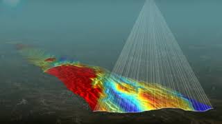
- Laser Scanners: These are employed for 3D modeling of construction sites, enabling accurate data capture for complex structures.
- Drones/UAVs: Drones facilitate aerial surveying and progress monitoring, allowing for rapid data collection and interpretation over large areas.
The utilization of these tools not only enhances precision but also improves the efficiency of the survey process, making it essential for successful project execution.
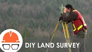
Youtube Videos


Audio Book
Dive deep into the subject with an immersive audiobook experience.
Conventional Instruments
Chapter 1 of 6
🔒 Unlock Audio Chapter
Sign up and enroll to access the full audio experience
Chapter Content
- Dumpy Levels and Theodolites
- Chain, Tape, and Leveling Staff
Detailed Explanation
Conventional instruments are traditional tools used in construction surveys that have been employed for many years. Dumpy levels and theodolites are optical devices that help surveyors measure angles and levels accurately. A dumpy level enables surveyors to establish horizontal planes, crucial for building foundations or grading land. Theodolites measure both horizontal and vertical angles, which are essential for tasks such as setting out structures or aligning roads. Chains, tapes, and leveling staffs are straightforward but vital tools used for measuring distances accurately.
Examples & Analogies
Think of a dumpy level as a carpenter's spirit level with enhanced capabilities, allowing them to ensure that the ground is flat before building a house on it. Just as a carpenter checks the level of a shelf, surveyors use these instruments to check levels on much larger scales.
Total Station
Chapter 2 of 6
🔒 Unlock Audio Chapter
Sign up and enroll to access the full audio experience
Chapter Content
- Total Station: For angle and distance measurement with onboard data logging.
Detailed Explanation
A Total Station is a sophisticated electronic instrument that combines the functionalities of a theodolite with electronic distance measurement. It allows surveyors to measure angles, distances, and automatically log this data into its onboard computer. This feature enables efficient data management and accuracy in construction projects, making it easier to record and analyze measurements directly on-site without needing separate tools.
Examples & Analogies
Imagine using a smartphone app that tracks your steps and calculates distances when you walk. The Total Station works similarly by accurately tracking measurements over a construction site and helping ensure everything is correctly aligned.
GNSS/GPS Receivers
Chapter 3 of 6
🔒 Unlock Audio Chapter
Sign up and enroll to access the full audio experience
Chapter Content
- GNSS/GPS Receivers: For geospatial positioning in real-time kinematic (RTK) and static modes.
Detailed Explanation
GNSS (Global Navigation Satellite System) and GPS (Global Positioning System) receivers are critical for determining precise geographical locations. They can function in two main modes: RTK (Real-Time Kinematic), which provides instant high accuracy positioning, and static mode, used for post-processing data to achieve highly accurate results after the survey. This technology is vital for modern construction where precise positioning is essential for elements like road alignments and building placements.
Examples & Analogies
Think of how your smartphone can give you real-time directions to a destination. Just like how your GPS app provides constant updates on your route, GNSS receivers enable surveyors to understand the exact position of their measurements on the ground accurately.
Digital Levels
Chapter 4 of 6
🔒 Unlock Audio Chapter
Sign up and enroll to access the full audio experience
Chapter Content
- Digital Levels: For accurate height measurements.
Detailed Explanation
Digital levels are advanced tools that measure height and levels with greater precision than traditional leveling instruments. They use electronic sensors and digital displays to provide readings, reducing human error that often occurs in manual measurements. Digital levels help in ensuring that construction elements are built to the correct elevations, which is crucial for stability and drainage.
Examples & Analogies
Consider how a digital thermometer provides a quick and accurate temperature reading compared to a traditional one. Similarly, digital levels streamline the process of measuring heights, making the work of surveyors more reliable and efficient.
Laser Scanners
Chapter 5 of 6
🔒 Unlock Audio Chapter
Sign up and enroll to access the full audio experience
Chapter Content
- Laser Scanners: For 3D modelling of construction sites.
Detailed Explanation
Laser scanners are cutting-edge devices that use laser beams to capture precise 3D measurements of an entire environment. They create highly detailed 'point clouds,' which can be processed into 3D models of the surveyed area. This technology is invaluable for visualizing construction sites and conducting detailed assessments, allowing for more informed decision-making during project planning and execution.
Examples & Analogies
Think of a laser scanner as a high-tech version of a photographer who captures every angle of a scene. Just like a photographer creates a detailed image from multiple pictures, the laser scanner generates a comprehensive 3D model from scans, enabling surveyors to get a complete picture of the site.
Drones/UAVs
Chapter 6 of 6
🔒 Unlock Audio Chapter
Sign up and enroll to access the full audio experience
Chapter Content
- Drones/UAVs: For aerial surveying and progress monitoring.
Detailed Explanation
Drones, or Unmanned Aerial Vehicles (UAVs), are increasingly being utilized in construction surveys primarily for aerial surveying and monitoring project progress. They can cover large areas quickly, capturing high-resolution images and data that are beneficial for assessments and planning. Drones facilitate tasks such as monitoring changes over time and ensuring work is progressing as planned.
Examples & Analogies
Think of drones like modern-day birds that provide a bird's eye view of a construction site. Just as birds can see a wide landscape from above, drones give surveyors and project managers efficient oversight of developments, making it easy to spot any potential issues early.
Key Concepts
-
Dumpy Levels and Theodolites: Important for leveling and angle measurement.
-
Total Station: Combines angle and distance measurement with data logging capabilities.
-
GNSS Receivers: Provide real-time global positioning.
-
Laser Scanners: Used for 3D modeling and capturing complex structures.
-
Drones: Facilitate rapid data collection for aerial surveys.
Examples & Applications
A construction project uses a total station to accurately measure distances and angles on-site.
In a large-scale highway project, GNSS receivers are employed for precision in route alignment.
Memory Aids
Interactive tools to help you remember key concepts
Rhymes
When leveling a site, a dumpy light, will help make sure everything's right.
Stories
Imagine a builder named Tommy. He conducts a survey with a trusty total station that helps him lay down foundations perfectly, earning him the reputation of a precise architect.
Memory Tools
To remember survey instruments: 'Drones, Total stations, Lasers, and GNSS' = DT-LG.
Acronyms
For conventional instruments
'DTV' - Dumpy
Theodolite
and Vision (for sight measurement).
Flash Cards
Glossary
- Dumpy Level
A surveying instrument used to establish horizontal planes during construction.
- Theodolite
A precision instrument for measuring angles in horizontal and vertical planes.
- Total Station
An electronic/optical instrument used in modern surveying for measuring distances and angles.
- GNSS/GPS Receiver
A device that uses satellite signals to determine geographic locations.
- Laser Scanner
An instrument that captures 3D data of objects and landscapes.
- Drones/UAVs
Unmanned aerial vehicles used for aerial surveying.
Reference links
Supplementary resources to enhance your learning experience.