
As-Built Surveys
Enroll to start learning
You’ve not yet enrolled in this course. Please enroll for free to listen to audio lessons, classroom podcasts and take practice test.
Interactive Audio Lesson
Listen to a student-teacher conversation explaining the topic in a relatable way.
Purpose of As-Built Surveys
🔒 Unlock Audio Lesson
Sign up and enroll to listen to this audio lesson

Today, we're going to discuss the purpose of as-built surveys. Can anyone tell me why we perform as-built surveys after construction?

I think it's to check if everything was built according to the design.
Exactly! As-built surveys help verify that the finished structure matches the design specifications. What else do you think is important about these surveys?

They might help with future modifications or repairs?
Correct! They create essential documentation that aids in future maintenance and compliance. Remember this: documentation is key. Let’s summarize: as-built surveys confirm construction accuracy and provide vital records for future use.
Techniques Used for As-Built Surveys
🔒 Unlock Audio Lesson
Sign up and enroll to listen to this audio lesson

Now, let's talk about the techniques used in as-built surveys. Who can name one technique?

Total stations are used for measuring angles and distances!
Great! Total stations are indeed fundamental for precise measurements. Can anyone mention a modern technique?

Maybe drones? They collect data quickly and from above.
Exactly! Drones provide aerial perspectives and create 3D models effectively. A hint to remember: drones are 'smart eyes in the sky.' In summary, as-built surveys utilize total stations and drones to enhance accuracy.
Integration with BIM
🔒 Unlock Audio Lesson
Sign up and enroll to listen to this audio lesson
Let's wrap up our discussion by talking about how as-built surveys integrate with BIM. Why is this integration important?
It helps project managers and engineers access all the updated information in one platform!
Exactly! Integrating as-built data with BIM enhances project management. What happens if the as-built data is incorrect?
That could lead to issues during maintenance or renovations!
Right again! Accurate data is crucial for effective future planning. To sum up, using BIM with as-built surveys allows easy accessibility and assists in efficient project management.
Introduction & Overview
Read summaries of the section's main ideas at different levels of detail.
Quick Overview
Standard
As-built surveys are critical for verifying actual construction outcomes against design intentions. They use advanced techniques, including total station measurements and drone photogrammetry, to create accurate records for project documentation and future maintenance.
Detailed
As-Built Surveys
As-built surveys are conducted to verify and document the actual locations, dimensions, and elevations of completed structures. This step is crucial in ensuring that the finished product aligns with original design specifications. They contribute to the creation of as-built drawings, which not only serve as project records but are also vital for compliance with regulatory requirements.
Purpose
- Verification of Construction: As-built surveys help confirm that the structures are built according to the specified coordinates and elevations, ensuring quality and compliance.
- Documentation: They generate necessary documentation for future reference, maintenance, and potential renovations.
Techniques Used
- Total Station Measurements: These provide precise measurements essential for accurate documentation.
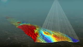
- Drone Photogrammetry and LiDAR: They are employed to create 3D as-built models that enhance visualization and data accuracy.
- Integration with BIM: As-built data can be incorporated into Building Information Modeling platforms for enhanced project management and future use.
These methods help maintain a high degree of accuracy and provide real-time insights into the as-built conditions of the construction project.
Youtube Videos


Audio Book
Dive deep into the subject with an immersive audiobook experience.
Purpose of As-Built Surveys
Chapter 1 of 2
🔒 Unlock Audio Chapter
Sign up and enroll to access the full audio experience
Chapter Content
- Verifying and documenting the actual location, dimensions, and elevations of completed structures.
- Creating as-built drawings for project records and compliance.
Detailed Explanation
As-built surveys serve a critical role in the construction process by providing accurate information about how the final built environment compares to the original design plans. This involves meticulously measuring the location, size, and height of various structures and comparing these to the expected specifications. The results of this survey are then used to create as-built drawings, which are essential records that can aid in future maintenance, renovations, or any legal disputes regarding the construction.
Examples & Analogies
Imagine building a bookshelf. You follow a design plan that outlines how tall and wide each shelf should be. Once the bookshelf is built, you measure it to see if it matches your plan. This measurement is comparable to an as-built survey; it ensures that what you constructed matches what you intended to build. If you need to make changes in the future or add additional shelves, having this record will make it much easier.
Techniques Used in As-Built Surveys
Chapter 2 of 2
🔒 Unlock Audio Chapter
Sign up and enroll to access the full audio experience
Chapter Content
- Total station-based measurement.
- Drone photogrammetry and LiDAR for 3D as-built models.
- Integration with BIM (Building Information Modeling) platforms.
Detailed Explanation
Several advanced techniques are employed in conducting as-built surveys. One of the most common tools is the total station, which uses angles and distance measurements to provide precise data about the construction. Additionally, drone photogrammetry captures aerial images of the construction site, while LiDAR technology can produce 3D models that provide detailed spatial information. Integration with BIM platforms allows these measurements to be instantly visualized in a digital format, which aids architects and engineers in making decisions about the building's future.
Examples & Analogies
Think of how modern video games are created. Game developers use various technology to create 3D models of characters and environments, enabling players to explore them. Similarly, in as-built surveys, total stations, drones, and LiDAR help document buildings in three dimensions, making it easier for engineers and architects to visualize and assess the final product against their design.
Key Concepts
-
As-built surveys are essential for verifying the accuracy of construction against design specifications.
-
They utilize advanced techniques such as total stations and drones to enhance accuracy.
-
Integration with BIM allows for improved project management and easy access to updated information.
Examples & Applications
An as-built survey reveals that a bridge was constructed 2 feet lower than planned, affecting structural integrity.
A drone survey provides a detailed 3D model of a newly built highway, allowing for better visualization and planning.
Memory Aids
Interactive tools to help you remember key concepts
Rhymes
When you build with care, don’t forget to compare, as-built surveys show where things are rare.
Stories
Imagine a construction site where a builder discovers the bridge is two feet low; the as-built survey shows the right way to go!
Memory Tools
Remember 'ACT' for As-built surveys: A for 'Accuracy', C for 'Compliance', T for 'Documentation'.
Acronyms
A-B-S
As-Built Surveys - 'A' for Accuracy
'B' for Building
'S' for Specifications.
Flash Cards
Glossary
- AsBuilt Surveys
Surveys that document the actual location, dimensions, and elevations of completed structures.
- Total Station
An optical/electronic instrument used for surveying and building construction, capable of measuring angles and distances.
- Drone Photogrammetry
The use of drones to capture images and create 3D models or maps of a site's geography.
- Building Information Modeling (BIM)
A digital representation of the physical and functional characteristics of a facility, integrated into a shared knowledge resource.
Reference links
Supplementary resources to enhance your learning experience.