
Global Navigation Satellite Systems (GNSS): Overview
Enroll to start learning
You’ve not yet enrolled in this course. Please enroll for free to listen to audio lessons, classroom podcasts and take practice test.
Interactive Audio Lesson
Listen to a student-teacher conversation explaining the topic in a relatable way.
Definition of GNSS
🔒 Unlock Audio Lesson
Sign up and enroll to listen to this audio lesson

Today, class, we'll explore what GNSS means. GNSS stands for Global Navigation Satellite Systems. Can anyone tell me what they think this term encompasses?

Is it only about GPS, or are there other systems included?
Great question! While GPS is a part of GNSS, it's not the only one. GNSS includes multiple satellite systems around the world that provide positioning, navigation, and timing services globally. Can anyone name some of these systems?

I've heard about GLONASS from Russia!

What about Galileo from Europe?
Exactly! We have GLONASS, Galileo, BeiDou from China, and others. Remember, GNSS acts like a collection of systems that work together.

So, it's like a team of satellites helping us know where we are?
Precisely! Think of GNSS as a global team providing accurate positioning data. Great understanding, everyone!
Key GNSS Systems
🔒 Unlock Audio Lesson
Sign up and enroll to listen to this audio lesson

Now that we know what GNSS is, let’s discuss some key GNSS systems, starting with GPS. Who can tell me about its origins?
It was developed by the U.S. Department of Defense!
Correct! GPS became fully operational in 1995, initially meant for military purposes but later opened for civilian use. How about GLONASS, what do we know about it?
It's Russia's version of GPS, right?
That's right! And we also have Galileo in the EU, BeiDou in China, and regional systems like NAVIC in India. Can someone explain why having multiple GNSS is beneficial?
I guess it improves accuracy and availability of signals!
Exactly! By combining the signals from these various systems, users can experience better accuracy and redundancy in positioning.
Applications of GNSS
🔒 Unlock Audio Lesson
Sign up and enroll to listen to this audio lesson
Now, let’s talk about the applications of GNSS. Why do you think civil engineering relies heavily on GNSS?
It probably helps with surveying and mapping?
Yes! GNSS is crucial for accurate surveying. It also plays roles in disaster management and infrastructure development. Can you all think of more practical applications?
How about in navigation for vehicles?
Or even for smartphones and personal devices!
Great examples! GNSS provides critical data that feeds into many aspects of daily life and technological advancements.
Introduction & Overview
Read summaries of the section's main ideas at different levels of detail.
Quick Overview
Standard
This section introduces GNSS, detailing how it includes multiple systems such as GPS, GLONASS, and others. Each system enhances positioning accuracy and availability through satellite constellations, ground control, and user segments, with crucial applications in civil engineering, disaster management, and navigation.
Detailed
Global Navigation Satellite Systems (GNSS): Overview
Global Navigation Satellite Systems (GNSS) is a term that refers to a suite of satellite systems that provide essential services in positioning, navigation, and timing (PNT) to users anywhere on Earth. This section details the definition of GNSS and highlights key GNSS systems, contrasting these with GPS, which is a specific U.S.-based system.
Key Components of GNSS
- Definition of GNSS: GNSS encompasses various satellite constellations, making it a broader term than GPS.
- Key GNSS Systems:
- GPS (USA): The most recognized global positioning system.
- GLONASS (Russia): Russia's equivalent to GPS, enhancing global navigational accuracy.
- Galileo (EU): The European initiative for GNSS.
- BeiDou (China): Another major global navigation system from China.
- NAVIC (IRNSS - India): A regional system primarily catering to India.
- QZSS (Japan): A quasi-zenith system designed to improve GPS accuracy in Japan.
These systems work together, leveraging multiple satellites and ground controls to enhance accuracy, availability, and redundancy, crucial for applications in civil engineering, disaster management, and urban planning. Understanding GNSS’ broad and crucial role helps underscore its impact on modern technology and infrastructure.
Youtube Videos


Audio Book
Dive deep into the subject with an immersive audiobook experience.
Definition of GNSS
Chapter 1 of 2
🔒 Unlock Audio Chapter
Sign up and enroll to access the full audio experience
Chapter Content
GNSS refers to a collection of satellite constellations that provide positioning, navigation, and timing (PNT) services globally. Unlike GPS, which is a U.S.-based system, GNSS is a generic term encompassing multiple satellite systems.
Detailed Explanation
GNSS stands for Global Navigation Satellite Systems. It includes various satellite networks that help determine where we are on the Earth using satellites. While GPS is specifically the U.S. system, GNSS covers many systems worldwide, providing services like location tracking and time synchronization. This means multiple countries operate their own satellite systems, and when we reference GNSS, we include all of them, not just GPS.
Examples & Analogies
Think of GNSS like a global team of searchlights. Just as searchlights can illuminate an area from different angles to help people find their way, GNSS uses various satellites in different positions around the Earth to help people pinpoint their location anytime, anywhere.
Key GNSS Systems
Chapter 2 of 2
🔒 Unlock Audio Chapter
Sign up and enroll to access the full audio experience
Chapter Content
• GPS (Global Positioning System) – USA
• GLONASS – Russia
• Galileo – European Union
• BeiDou – China
• NAVIC (IRNSS) – India (Regional system)
• QZSS – Japan (Quasi-Zenith Satellite System)
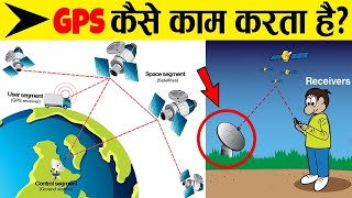
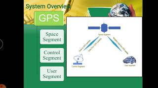
Each system has a constellation of satellites, ground control stations, and user segments. When combined, they enhance availability, accuracy, and redundancy.
Detailed Explanation
There are several major GNSS systems: GPS from the USA, GLONASS from Russia, Galileo from the European Union, BeiDou from China, NAVIC from India, and QZSS from Japan. Each of these systems operates its own satellites, ground control stations, and receivers. When these systems are used together, they make locating positions more accurate and reliable because having multiple systems means that there is a backup if one fails, thus ensuring better service overall.
Examples & Analogies
Imagine using different types of transportation to get to your destination, like cars, buses, and trains. Each mode has its strengths and weaknesses. When you combine them, you have more options and routes to ensure you reach your goal efficiently. GNSS functions similarly by combining multiple satellite systems to provide more dependable and precise location services.
Key Concepts
-
GNSS: A broad term for satellite systems providing global positioning.
-
GPS: A specific system under GNSS developed by the USA.
-
GLONASS, Galileo, BeiDou, NAVIC, QZSS: Key GNSS systems each serving different regions.
Examples & Applications
GPS is widely used in cars for navigation and mapping.
Galileo provides services across Europe, improving navigation accuracy.
Memory Aids
Interactive tools to help you remember key concepts
Rhymes
If you want to know your place, look at the stars in outer space. GNSS leads the way, by satellites, night or day.
Stories
Imagine a group of friends, each carrying a compass. They decide to help each other find their way in a vast forest using their individual compasses. Together, they ensure everyone gets home safely, just like how GNSS systems work together to provide accurate positioning.
Memory Tools
To remember key GNSS systems use: 'G G B N Q' for Galileo, GLONASS, BeiDou, NAVIC, and QZSS.
Acronyms
GNSS
is for Global
is for Navigation
is for Satellite
and the last S is for System!
Flash Cards
Glossary
- GNSS
Global Navigation Satellite Systems; a term that refers to all satellite systems providing global positioning and navigation services.
- GPS
Global Positioning System, a U.S.-developed satellite navigation system that offers accurate positioning services.
- GLONASS
The Russian satellite navigation system that works similarly to GPS.
- Galileo
The European global navigation satellite system providing accurate positioning.
- BeiDou
China's satellite navigation system, which also provides global services.
- NAVIC
India's regional satellite navigation system.
- QZSS
The Quasi-Zenith Satellite System operated by Japan to enhance GPS services.
Reference links
Supplementary resources to enhance your learning experience.