
GNSS Augmentation Systems
Enroll to start learning
You’ve not yet enrolled in this course. Please enroll for free to listen to audio lessons, classroom podcasts and take practice test.
Interactive Audio Lesson
Listen to a student-teacher conversation explaining the topic in a relatable way.
Introduction to GNSS Augmentation Systems
🔒 Unlock Audio Lesson
Sign up and enroll to listen to this audio lesson

Welcome everyone! Today, we'll dive into GNSS Augmentation Systems. Can anyone tell me what GNSS stands for?

I believe it stands for Global Navigation Satellite System.
Exactly! Now, augmentation systems improve the accuracy of these satellite systems. Can anyone name the two main types of augmentation systems?

Is it SBAS and GBAS?
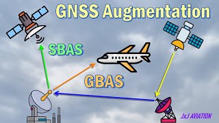
Correct! SBAS stands for Satellite-Based Augmentation System, while GBAS stands for Ground-Based Augmentation System. Let's explore SBAS first.
Satellite-Based Augmentation Systems (SBAS)
🔒 Unlock Audio Lesson
Sign up and enroll to listen to this audio lesson

SBAS provides correction information via geostationary satellites. Can anyone name some examples of SBAS?

WAAS in the USA and EGNOS in Europe!
Great! WAAS is indeed a popular example, and it enhances GPS accuracy across North America. Why is this important?

Because it helps improve accuracy for users like pilots and surveyors.
Exactly! Accurate positioning is critical in numerous applications, particularly in aviation.
Ground-Based Augmentation Systems (GBAS)
🔒 Unlock Audio Lesson
Sign up and enroll to listen to this audio lesson
Now, let’s shift our focus to Ground-Based Augmentation Systems. GBAS provides localized corrections. In what context do you think GBAS is primarily used?
I think it is primarily used in aviation for aircraft landings.
Correct! GBAS is vital for ensuring precision during airport approaches, which enhances safety. Can anyone think of a benefit of using GBAS?
It can allow for landings in poor visibility conditions.
Absolutely! These systems are crucial in ensuring safety and efficiency in air travel.
Applications and Importance of Augmentation Systems
🔒 Unlock Audio Lesson
Sign up and enroll to listen to this audio lesson
So far, we covered SBAS and GBAS. Let’s discuss their applications. How do you think these systems benefit civil engineering?
They help provide precise positioning for surveying and mapping.
And they are crucial in disaster response and management navigation.
Exactly! Augmentation systems play a significant role in various fields, enhancing overall operational accuracy and safety.
Introduction & Overview
Read summaries of the section's main ideas at different levels of detail.
Quick Overview
Standard
This section discusses GNSS augmentation systems, focusing on Satellite-Based Augmentation Systems (SBAS) and Ground-Based Augmentation Systems (GBAS), explaining their roles, examples, and applications to improve the precision of GNSS.
Detailed
GNSS Augmentation Systems
GNSS augmentation systems are essential components that enhance the accuracy and reliability of Global Navigation Satellite Systems (GNSS). These systems, primarily divided into Satellite-Based Augmentation Systems (SBAS) and Ground-Based Augmentation Systems (GBAS), provide supplementary correction information which allows GNSS receivers to achieve higher precision in positioning and timing. SBAS utilizes geostationary satellites to relay correction data, enabling improvements across broad regions, whereas GBAS focuses on localized corrections, particularly in aviation to optimize approaches and landings. Notable examples include WAAS in the USA, EGNOS in Europe, and various other regional systems. Understanding these augmentation systems is crucial for civil engineering applications where precise navigation and positioning are paramount.
Youtube Videos


Audio Book
Dive deep into the subject with an immersive audiobook experience.
What are GNSS Augmentation Systems?
Chapter 1 of 3
🔒 Unlock Audio Chapter
Sign up and enroll to access the full audio experience
Chapter Content
GNSS Augmentation Systems enhance the performance of basic GNSS signals. They provide additional correction data to improve positioning accuracy and reliability.
Detailed Explanation
GNSS, which includes systems like GPS, provides good positioning accuracy on its own. However, augmentation systems take this a step further by correcting errors in the signal. These errors can come from factors such as atmospheric conditions or satellite clock inaccuracies. The augmentation systems provide users with more precise location data by making these corrections.
Examples & Analogies
Think of GNSS as a regular smartphone camera. It can take decent photos, but to improve photo quality significantly, you might add a lens filter or a tripod. Similarly, GNSS augmentation systems act like these accessories, enhancing the basic signal to provide a clearer and more precise location.
Satellite-Based Augmentation Systems (SBAS)
Chapter 2 of 3
🔒 Unlock Audio Chapter
Sign up and enroll to access the full audio experience
Chapter Content
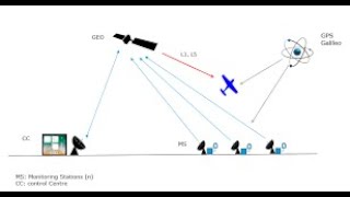
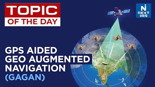
SBAS provides correction information via geostationary satellites. Examples include WAAS (USA), EGNOS (Europe), GAGAN (India), and MSAS (Japan).
Detailed Explanation
Satellite-Based Augmentation Systems work by using additional satellites that remain in a fixed position relative to the Earth. They transmit correction data to GNSS receivers to correct inaccuracies. For instance, the Wide Area Augmentation System (WAAS) in the USA is used primarily for aviation and can improve GNSS accuracy significantly in its coverage area.
Examples & Analogies
Imagine trying to read a map in a car while going over bumps. The bumps make it hard to see where you are going. An SBAS would be like a navigator who helps you by pointing out the right turns and correcting your path in real-time, making your journey smoother and more accurate.
Ground-Based Augmentation Systems (GBAS)
Chapter 3 of 3
🔒 Unlock Audio Chapter
Sign up and enroll to access the full audio experience
Chapter Content
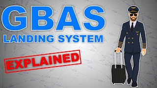
GBAS provides localized corrections near airports specifically for aircraft landing.
Detailed Explanation
Ground-Based Augmentation Systems enhance GNSS performance by providing corrections from ground stations located near airports. This is particularly useful for aviation, where precise location information is crucial for safe landings. GBAS systems continuously monitor satellite signals and send correction data to aircraft to ensure they are on the correct path and altitude.
Examples & Analogies
Consider GBAS to be like a ground crew signaling to a pilot during landing. Just as ground crew members guide planes to the runway with precise instructions for safe landings, GBAS systems give aircraft the detailed corrections they need to land safely and accurately, ensuring pilots know exactly where they are at all times.
Key Concepts
-
SBAS: Enhances GNSS accuracy using geostationary satellites.
-
GBAS: Provides localized corrections for aviation.
Examples & Applications
WAAS (Wide Area Augmentation System) enhances GPS in North America for various applications, especially aviation.
EGNOS (European Geostationary Navigation Overlay Service) offers GNSS corrections across Europe for improved accuracy.
Memory Aids
Interactive tools to help you remember key concepts
Rhymes
'SBAS in the sky, makes GPS fly high, while GBAS on the ground, great landing's found.'
Stories
Imagine a pilot relies on SBAS signals from space to navigate accurately, while arriving at the airport and switching to GBAS ensures a safe landing on the runway.
Memory Tools
Remember 'SBAS' for Satellites and 'GBAS' for Ground.
Acronyms
'SBAS' - Satellites Boost Accuracy, 'GBAS' - Ground-Based Accuracy Systems.
Flash Cards
Glossary
- SBAS
Satellite-Based Augmentation System; a system that provides correction information via geostationary satellites.
- GBAS
Ground-Based Augmentation System; a system that provides localized corrections, primarily used in aviation near airports.
Reference links
Supplementary resources to enhance your learning experience.