
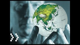
Global Positioning System (GPS) & GNSS
Enroll to start learning
You’ve not yet enrolled in this course. Please enroll for free to listen to audio lessons, classroom podcasts and take practice test.
Interactive Audio Lesson
Listen to a student-teacher conversation explaining the topic in a relatable way.
Introduction to GNSS and its Key Systems
🔒 Unlock Audio Lesson
Sign up and enroll to listen to this audio lesson

Today, we'll start by understanding what GNSS stands for. Can anyone tell me what GNSS is?

Is it a global navigation system?
That's a good start! GNSS actually stands for Global Navigation Satellite Systems. It encompasses various satellite constellations including GPS, GLONASS, Galileo, and others. These systems are crucial for providing positioning, navigation, and timing services. Remember this acronym, GNSS, because it's important in understanding global positioning.

What are those key systems?
Great question! To summarize, GPS is from the USA, GLONASS is from Russia, Galileo from the EU, BeiDou from China, and NAVIC is India’s regional system. These systems work together to improve accuracy and reliability. Can anyone remember what GNSS stands for?

Global Navigation Satellite Systems!
Excellent! Let’s keep that knowledge as we delve deeper.
Components of GPS
🔒 Unlock Audio Lesson
Sign up and enroll to listen to this audio lesson

Now, let’s talk about the components of GPS. Can anyone name the segments of GPS?
Is there a space segment?
Correct! The first segment is the Space Segment, comprising at least 24 satellites orbiting the Earth. What do you think the other segments are?
Is there a control segment too?
Yes! The Control Segment monitors the satellites' health and manages their paths. Lastly, we have the User Segment - where all the GPS receivers are located. Can someone tell me why having these segments is important?

To ensure that we always know our position?
Exactly! These segments work together to provide accurate positioning. Remember, Space, Control, User - 'SCU' can be a mnemonic to help recall!
Principles of Positioning
🔒 Unlock Audio Lesson
Sign up and enroll to listen to this audio lesson
Let’s explore how GPS determines our location. What techniques does it use for positioning?
Is it triangulation?
Close! The precise method is called trilateration. It relies on the distances from at least four satellites. Can anyone explain how it works?
Each satellite sends a signal with its position and timestamp!
Right! The receiver calculates the time delay of signals to determine distances. And what role does time synchronization play?
It helps ensure the distances are accurate by correcting any clock differences.
Exactly, well done! Accurate timing is crucial for precise positioning, especially with atomic clocks in satellites.
Sources of GPS Errors
🔒 Unlock Audio Lesson
Sign up and enroll to listen to this audio lesson
Next, let’s look at something crucial—GPS errors. Can anyone think of sources that might impact GPS accuracy?
Maybe signal delays from the atmosphere?
Correct! Atmospheric delays from ionospheric and tropospheric conditions can cause inaccuracies. What about physical obstructions like buildings?
Yes, buildings can reflect signals, causing multipath errors.
Good point! There are also satellite clock errors and ephemeris errors. Always remember: these errors need to be minimized for accurate readings!
Applications of GPS in Civil Engineering
🔒 Unlock Audio Lesson
Sign up and enroll to listen to this audio lesson
Finally, let’s connect GPS to civil engineering. How do you think GPS is beneficial in this field?
It helps with surveying and mapping!
Absolutely! GPS allows for rapid and accurate surveying, which is critical for construction projects. What are some other applications you can think of?
Maybe traffic management and tracking?
Yes! It’s used for fleet tracking and optimizing routes. It’s fascinating how GNSS applications keep evolving. Remember, in civil engineering, it’s not just about what we build but how we use technology to enhance our processes!
Introduction & Overview
Read summaries of the section's main ideas at different levels of detail.
Quick Overview
Standard
This section provides an overview of GNSS, detailing the various satellite systems including GPS, GLONASS, and Galileo. It covers the history, development, segmentation of GPS, principles of positioning, source of errors, and advanced methods like DGPS and RTK. The applications in civil engineering and the future directions of GNSS are also highlighted.
Detailed
The Global Positioning System (GPS) and Global Navigation Satellite Systems (GNSS) are essential in modern civil engineering and geospatial sciences, offering precise location information worldwide. This section begins with an overview definition of GNSS as a collection of satellite constellations providing positioning, navigation, and timing (PNT) services. Key systems under GNSS are discussed, including GPS developed by the U.S. Department of Defense, GLONASS from Russia, Galileo from the European Union, BeiDou from China, and others. \n\nThe section delves into GPS's history, its operational segments (Space, Control, User), principles like triangulation and trilateration, and the critical role of time synchronization through atomic clocks. The GPS signal structure, sources of GPS error, and concepts of Differential GPS (DGPS) for accuracy improvement are also examined. \n\nAdvanced techniques like Real-Time Kinematic (RTK) positioning, GNSS augmentation systems, and their applications in civil engineering are revealed. The emerging trends in GNSS technology, including multi-constellation receivers and high-precision GNSS chips in smartphones, outline the potential future developments. Lastly, this section presents the legal and ethical considerations, challenges, and future directions in GNSS applications for civil engineering, emphasizing its transformative impact.
Youtube Videos


Audio Book
Dive deep into the subject with an immersive audiobook experience.
Introduction to GPS and GNSS
Chapter 1 of 5
🔒 Unlock Audio Chapter
Sign up and enroll to access the full audio experience
Chapter Content
In the modern era of civil engineering and geospatial sciences, the ability to determine precise locations anywhere on Earth is foundational. The Global Positioning System (GPS), along with other satellite navigation systems under the broader term Global Navigation Satellite Systems (GNSS), plays a vital role in surveying, mapping, infrastructure development, disaster management, and navigation. These systems use a constellation of satellites to provide real-time geolocation and time information to a GPS/GNSS receiver anywhere on or near the Earth's surface.
Detailed Explanation
This introduction emphasizes the importance of GPS and GNSS in various fields such as civil engineering and geospatial sciences. GPS is a specific system developed by the U.S., while GNSS refers to a collection of satellite navigation systems from multiple countries that together provide global positioning services. These systems help in pinpointing locations accurately and provide time information, which is crucial for various applications like surveying infrastructure, coordinating disaster response, and managing transportation efficiently.
Examples & Analogies
Think of GPS like your smartphone's map application that helps you find the fastest route to a restaurant. Just as your phone determines your location using signals from satellites, GNSS operates by leveraging signals from a network of satellites to provide accurate location information for many different applications.
4.1 Global Navigation Satellite Systems (GNSS): Overview
Chapter 2 of 5
🔒 Unlock Audio Chapter
Sign up and enroll to access the full audio experience
Chapter Content
GNSS refers to a collection of satellite constellations that provide positioning, navigation, and timing (PNT) services globally. Unlike GPS, which is a U.S.-based system, GNSS is a generic term encompassing multiple satellite systems.
Detailed Explanation
The section defines GNSS, allowing us to understand that it includes various satellite systems beyond just GPS. GNSS systems like GLONASS (Russia), Galileo (EU), BeiDou (China), and others work together to improve service reliability, coverage, and accuracy, making GNSS more versatile for users around the world.
Examples & Analogies
Imagine you are in a group of friends each carrying a smartphone with different map applications. While each app offers slightly varied routes, their collective coverage ensures that no matter where you are, you can access accurate navigation. This is similar to how GNSS systems work together to provide comprehensive positioning services globally.
4.1.2 Key GNSS Systems
Chapter 3 of 5
🔒 Unlock Audio Chapter
Sign up and enroll to access the full audio experience
Chapter Content
- GPS (Global Positioning System) – USA
- GLONASS – Russia
- Galileo – European Union
- BeiDou – China
- NAVIC (IRNSS) – India (Regional system)
- QZSS – Japan (Quasi-Zenith Satellite System)
Each system has a constellation of satellites, ground control stations, and user segments. When combined, they enhance availability, accuracy, and redundancy.
Detailed Explanation
This chunk lists various GNSS systems, highlighting their origins and types. It includes GPS as the primary U.S. system and identifies other significant systems such as GLONASS from Russia and Galileo from the European Union. Each GNSS is tailored to specific needs but works collaboratively to ensure global positioning remains accurate and dependable, significantly improving how users receive location-based data.
Examples & Analogies
Think of each GNSS system as a layer of a protective net that ensures no matter which way you throw a ball (or, in this case, request location data), it's likely to be caught accurately. The more systems (or net layers) available, the less likely you are to miss a catching opportunity, even in challenging environments.
4.2 GPS – Global Positioning System
Chapter 4 of 5
🔒 Unlock Audio Chapter
Sign up and enroll to access the full audio experience
Chapter Content
GPS was developed by the U.S. Department of Defense in the 1970s and was declared fully operational in 1995. Originally for military use, it was later opened to civilians.
Detailed Explanation
This chunk discusses the history and development of GPS, explaining its initial purpose for military applications and its evolution into a civilian tool. Its establishment in the mid-1990s marked a significant change in the accessibility of precise location data, facilitating advancements across various fields, including transportation and construction.
Examples & Analogies
Consider GPS like a top-secret recipe initially known only to a chef for military parties, which later gets published for everyone to use. Once available to the public, restaurants (and everyday people) suddenly can provide better navigation and services, showcasing how shared resources can improve overall quality.
4.2.2 Segments of GPS
Chapter 5 of 5
🔒 Unlock Audio Chapter
Sign up and enroll to access the full audio experience
Chapter Content
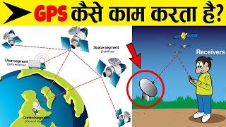
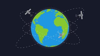
a) Space Segment - Comprises a constellation of at least 24 satellites orbiting at ~20,200 km above Earth in 6 orbital planes. Each satellite orbits Earth twice a day.
b) Control Segment - Master Control Station (MCS) located in Colorado, USA, with ground antennas and monitoring stations spread globally. Functions: satellite health monitoring, clock correction, orbit update.
c) User Segment - GPS receivers in mobile devices, surveying equipment, vehicles, etc. Receives satellite signals to calculate 3D position and time.
Detailed Explanation
This chunk breaks down GPS into three main components: the Space Segment, Control Segment, and User Segment. The Space Segment consists of satellites that provide the necessary information; the Control Segment is responsible for maintaining the satellites' operational readiness; the User Segment is what we use daily, consisting of devices that receive data from the satellites to determine our positions.
Examples & Analogies
Imagine a GPS system like a concert performance. The satellites are the musicians (Space Segment) playing instruments to put on a show. The conductor (Control Segment) ensures musicians are playing in sync and staying on beat, while the audience (User Segment) enjoys the music directly through their unique experiences, like your GPS device providing navigation.
Key Concepts
-
Trilateration: A method to find position based on distances from satellites.
-
Segments of GPS: Space, Control, and User segments that collectively provide GPS functionality.
-
Sources of GPS Error: Factors like signal obstruction, delays, synchronization issues, and multipath effects that can lead to inaccuracies.
Examples & Applications
Example of GPS in surveying: Accurately mapping land for construction projects using GPS data.
Example of DGPS: A base station located at a known position sends corrections to nearby GPS receivers.
Example of RTK: A construction team uses Real-Time Kinematic systems for precise placement of structural elements.
Memory Aids
Interactive tools to help you remember key concepts
Rhymes
To find your place in a space, satellites trace with grace, GNSS guides the race.
Stories
Imagine a postcard where the sender only initials their location, but with GNSS, you can pinpoint exactly where it was sent from, thanks to the satellites keeping track!
Memory Tools
To memorize GNSS systems: 'GREAT Big Gaps' (GPS, GLONASS, Galileo, BeiDou).
Acronyms
SCU for GPS Segments
Space
Control
User.
Flash Cards
Glossary
- GNSS
Global Navigation Satellite Systems; a collection of satellite systems providing positioning, navigation, and timing services.
- GPS
Global Positioning System; the U.S. satellite-based system for navigation and positioning.
- Trilateration
A process of determining a position by measuring distances from three or more satellites.
- Differential GPS (DGPS)
A method that uses a base station to provide corrections to GPS signals, improving accuracy.
Reference links
Supplementary resources to enhance your learning experience.