
GPS Signal Structure
Enroll to start learning
You’ve not yet enrolled in this course. Please enroll for free to listen to audio lessons, classroom podcasts and take practice test.
Interactive Audio Lesson
Listen to a student-teacher conversation explaining the topic in a relatable way.
Carrier Frequencies
🔒 Unlock Audio Lesson
Sign up and enroll to listen to this audio lesson

Today, let's discuss the carrier frequencies used by GPS. There are three primary frequencies: L1, L2, and L5. Can anyone tell me what the L1 frequency is typically used for?

Isn't L1 used for civilian purposes?
Correct! L1 operates at 1575.42 MHz and transmits the C/A code for civilian users. Now, what about L2? Student_2?

L2 is used primarily for military purposes, right?
Right again! L2 carries the encrypted P code. This separation helps ensure security in military operations. Finally, who can explain what L5 is intended for?

L5 is for safety-critical applications.
Exactly! L5 provides enhanced accuracy and reliability for critical applications. Remember, 'Civilians Love Safety', it can help you recall L1 for civilians, L5 for safety!
Codes Used in GPS
🔒 Unlock Audio Lesson
Sign up and enroll to listen to this audio lesson

Let’s move on to the codes used in GPS signals. There are two primary codes: C/A and P code. Student_4, can you explain what C/A code stands for and its use?

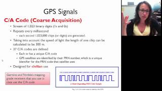
C/A stands for Coarse/Acquisition code, and it's used mainly for civilian applications.
Correct! The C/A code helps civilian users quickly acquire GPS signals. What about the P code? Student_1?
P code is the encrypted Precision code meant for military use?
Yes, and this encryption enhances security against unauthorized use. To remember these, think: 'Pizza Always' — P Code for Precise military and C/A as an accessible Civilian choice!
Navigation Message
🔒 Unlock Audio Lesson
Sign up and enroll to listen to this audio lesson
Next, we’ll dive into the navigation message. Why is this message critical for GPS function? Student_2, do you have thoughts?
It carries important data like satellite positions and time corrections, right?
Absolutely! The navigation message includes ephemeris data, almanac data, and clock corrections. This data ensures that your position is accurate and helps your receiver understand the satellite's current position. Remember: 'Every Astronaut Can' — Ephemeris, Almanac, Corrections!
Introduction & Overview
Read summaries of the section's main ideas at different levels of detail.
Quick Overview
Standard
The GPS signal structure is vital for the accurate functioning of the system. It includes various components like carrier frequencies (L1, L2, L5), codes (C/A for civilians and encrypted P code for military), and crucial data carried in navigation messages, which help in determining precise location through both code and carrier phase measurements.
Detailed
Detailed Summary
The GPS signal structure is a critical aspect of the Global Positioning System as it defines how the signals are transmitted and the essential elements they carry for effective positioning and navigation. The main components of the GPS signal structure include:
- Carrier Frequencies: GPS operates on three primary frequencies:
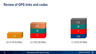
- L1 (1575.42 MHz): Primarily used for civilian applications, the L1 frequency transmits the C/A code.
- L2 (1227.60 MHz): Primarily utilized for military applications, transmitting the encrypted P code.
- L5 (1176.45 MHz): Designed for safety-critical applications, providing enhanced accuracy and reliability.
- C/A Code (Coarse/Acquisition): This code is used for civilian purposes and is essential for quick access to GPS signals.
- P Code (Precision): An encrypted code used for military purposes to enhance security and accuracy, ensuring that only authorized users can access precise positioning information.
- Navigation Message: This is a vital component that carries essential data such as ephemeris data (the satellite's position data), almanac data (general satellite status), and clock corrections to ensure accurate timekeeping.
- Code and Carrier Phase Measurements:
- Code Phase: This is utilized for determining quick, but less precise, position fixes.
- Carrier Phase: This is essential in high-precision applications like Real-Time Kinematic (RTK) surveying, which requires accurate phase measurements for centimeter-level precision.
Understanding the GPS signal structure is fundamental to the functional mechanics of GNSS, contributing to its application across various domains such as civil engineering, disaster management, and navigation.
Youtube Videos


Audio Book
Dive deep into the subject with an immersive audiobook experience.
Signal Components
Chapter 1 of 2
🔒 Unlock Audio Chapter
Sign up and enroll to access the full audio experience
Chapter Content
- Carrier frequencies: L1 (1575.42 MHz), L2 (1227.60 MHz), and L5 (1176.45 MHz)
- C/A Code (Coarse/Acquisition) – for civilian use
- P Code (Precision) – encrypted, for military use
- Navigation message: Contains ephemeris data, almanac, and clock corrections
Detailed Explanation
The GPS signal consists of several key components that allow it to function effectively. Each signal is transmitted on a different carrier frequency, primarily L1 (1575.42 MHz), L2 (1227.60 MHz), and L5 (1176.45 MHz). These frequencies are like different channels that allow the receiver to pick up signals from multiple satellites without interference. The C/A Code (Coarse/Acquisition Code) is used by civilian users to determine their position. In contrast, the P Code (Precision Code) is encrypted for military purposes, ensuring higher levels of security. Additionally, the GPS signals convey a navigation message, which includes crucial information such as the satellite's position (ephemeris), a broader data overview (almanac), and necessary clock corrections to maintain accuracy.
Examples & Analogies
Think of the GPS signal like a radio broadcast. Just as a radio station uses different frequencies to play different types of music without interference, GPS satellites use their specific frequencies to send location data. If you tune into the right frequency but don’t know the song title (akin to the satellite position), you won't be able to enjoy the music (accurate positioning). The C/A Code is like a playlist available to everyone, while the P Code is a premium playlist only accessible to select subscribers.
Code and Carrier Phase Measurements
Chapter 2 of 2
🔒 Unlock Audio Chapter
Sign up and enroll to access the full audio experience
Chapter Content
- Code Phase: Used for quick, rough positioning
- Carrier Phase: Used in high-precision surveying (e.g., RTK, DGPS)
Detailed Explanation
Two main methods exist to determine position: Code Phase and Carrier Phase measurements. The Code Phase is used for quick, rough positioning; it utilizes the timing of the signals being received to estimate the location. This method is sufficient for general navigation needs. On the other hand, Carrier Phase measurement involves analyzing the continuous wave signals to achieve much higher precision, which is critical in high-accuracy applications like surveying and geodetic work. Techniques such as Real-Time Kinematic (RTK) and Differential GPS (DGPS) heavily rely on Carrier Phase measurements to provide accuracy within a few centimeters.
Examples & Analogies
Imagine you're using a map app on your phone. When you first open the app, it needs to quickly find your location (like Code Phase). It might take a few seconds, but it gives you a rough idea of where you are. If you were a delivery driver needing precise directions to a specific address (akin to Carrier Phase), you'd want the app to give you real-time updates with pinpoint accuracy, rather than just an approximate location.