
Applications of Photogrammetry in Civil Engineering
Enroll to start learning
You’ve not yet enrolled in this course. Please enroll for free to listen to audio lessons, classroom podcasts and take practice test.
Interactive Audio Lesson
Listen to a student-teacher conversation explaining the topic in a relatable way.
Topographic Mapping
🔒 Unlock Audio Lesson
Sign up and enroll to listen to this audio lesson

Let's start with topographic mapping. Photogrammetry enables the creation of detailed contour maps and elevation models. Can anyone explain why this is crucial in civil engineering?

It's important because it helps in understanding the terrain for construction projects.
Exactly! By analyzing the topography, engineers can design structures that are safe and cost-effective. We use the acronym 'TERRAIN' to remember the steps involved in topographic mapping: T for Terrain analysis, E for Elevation modeling, R for Relief representation, R for Rate of slope, A for Area calculation, I for Infrastructure planning, and N for Navigation aids.

So, TERRAIN helps us remember the important aspects we consider in topographic mapping?
Yes! Now, can someone tell me one application of topographic mapping?

It can be used for site selection for new buildings!
Right! Great example. Understanding the terrain helps in making informed decisions. Let’s summarize: Topographic mapping is vital for analyzing terrain features essential for infrastructure planning.
Urban Planning
🔒 Unlock Audio Lesson
Sign up and enroll to listen to this audio lesson

Next, let’s discuss urban planning. Photogrammetry aids in land use analysis and helps extract building footprints. Why do you think this is significant?

It helps cities grow in an organized way by knowing where to build!
Correct! Without accurate data, urban sprawl can lead to inefficient land use. I like to remember the steps using 'SPLIT': S for Spatial data collection, P for Planning, L for Land use mapping, I for Infrastructure integration, and T for Transformation of urban spaces.
Can you repeat the acronym?
'SPLIT' helps in recalling our focus areas in urban planning. Can anyone give an example where this might be applied?
Urban sprawl analysis helps decide where to add new parks or schools.
Fantastic! Urban planning enhances community welfare and resource distribution. We learned that photogrammetry plays a key role in managing urban growth efficiently.
Disaster Management
🔒 Unlock Audio Lesson
Sign up and enroll to listen to this audio lesson
Let's look at disaster management. After a natural disaster, how can photogrammetry aid in assessments?
It can help create maps showing the extent of the damage!
Exactly! It allows for rapid assessment and planning for relief efforts. A way to remember this is 'CRASH': C for Damage assessment, R for Relief planning, A for Aerial imagery, S for Spatial accuracy, and H for Housing reconstruction.
So CRASH gives us a way to remember the key considerations during disaster management?
Absolutely! Focusing on these aspects allows for efficient response strategies. To conclude, photogrammetry is vital in managing disaster recoveries effectively.
Introduction & Overview
Read summaries of the section's main ideas at different levels of detail.
Quick Overview
Standard
This section discusses how photogrammetry is applied in several domains of civil engineering, including topographic mapping, urban planning, infrastructure assessment, and disaster management, emphasizing the importance of accurate spatial data in these processes.
Detailed
Applications of Photogrammetry in Civil Engineering
Photogrammetry is integral in civil engineering for capturing spatial information necessary for effective planning and development. Its applications include:
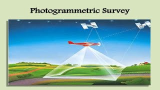
- Topographic Mapping: Utilizing aerial imagery to create detailed contour maps and elevation models, essential for understanding terrain.
- Urban Planning: Assisting in land use analysis and building footprint extraction to facilitate organized urban growth.
- Highway and Railway Engineering: Enabling corridor mapping and terrain assessment to support infrastructure development.
- Hydrology and Watershed Management: Providing critical data for basin mapping and flood modeling, which helps in managing water resources and prevents disasters.
- Mining and Geology: Helping in volume estimation of excavated materials and monitoring the condition of mining pits.
- Construction Monitoring: Allowing for progress tracking and volumetric computations to ensure that projects are on schedule and within budget.
- Disaster Management: Facilitating damage assessment and relief planning in the aftermath of natural disasters.
The integration of advanced technologies in photogrammetry enhances the ability of civil engineers to gather precise spatial data, which is fundamental for various applications.
Youtube Videos


Audio Book
Dive deep into the subject with an immersive audiobook experience.
Topographic Mapping
Chapter 1 of 7
🔒 Unlock Audio Chapter
Sign up and enroll to access the full audio experience
Chapter Content
• Topographic Mapping: Creation of contour maps and elevation models.
Detailed Explanation
Topographic mapping involves creating detailed maps that represent the features of a landscape, including elevations, slopes, and landforms. Photogrammetry is used to capture aerial images of an area, from which contour lines can be drawn to illustrate changes in elevation. These maps are essential for understanding the terrain for various engineering projects.
Examples & Analogies
Think of topographic maps like a 3D model of a cake. Just as a cake can be sliced to show different layers, a topographic map slices through the ground to show different elevation layers that are vital for construction projects, like a new road or building.
Urban Planning
Chapter 2 of 7
🔒 Unlock Audio Chapter
Sign up and enroll to access the full audio experience
Chapter Content
• Urban Planning: Land use analysis, building footprint extraction.
Detailed Explanation
In urban planning, photogrammetry allows urban planners to analyze land usage patterns. By capturing images of existing structures and open spaces, planners can create accurate representations of how land is used. This helps in making decisions about where to build new infrastructures, like schools and parks, by analyzing building footprints and spaces available for development.
Examples & Analogies
Imagine urban planners using drone images like a puzzle. They can see where each piece fits – like parks, schools, and housing – and figure out where to place the next piece in a way that makes the city better for everyone.
Highway and Railway Engineering
Chapter 3 of 7
🔒 Unlock Audio Chapter
Sign up and enroll to access the full audio experience
Chapter Content
• Highway and Railway Engineering: Corridor mapping and terrain assessment.
Detailed Explanation
Photogrammetry is crucial for highway and railway engineering as it helps in mapping corridors where new roads or tracks will be built. By assessing the terrain through aerial photography, engineers can determine the best routes to minimize environmental impact and reduce costs. This includes evaluating slopes and any potential obstacles that may be encountered during construction.
Examples & Analogies
Think of engineers as captains planning a ship's route through tricky waters. Just as captains look for the safest path to avoid obstacles and find smoother waters, engineers use photogrammetry to navigate the landscape for the safest and most efficient paths for transportation.
Hydrology and Watershed Management
Chapter 4 of 7
🔒 Unlock Audio Chapter
Sign up and enroll to access the full audio experience
Chapter Content
• Hydrology and Watershed Management: Basin mapping, flood modeling.
Detailed Explanation
In hydrology, photogrammetry aids in mapping river basins and analyzing watershed characteristics. This information is vital for flood modeling, where engineers predict how water flows during heavy rain. Understanding the terrain helps in planning flood management strategies and ensuring safety for nearby communities.
Examples & Analogies
Consider hydrologists as detectives working to solve a mystery of where water goes during a storm. Just like detectives gather clues to predict what might happen, hydrologists use photogrammetry to gather terrain data to predict how water will flow and where floods might occur.
Mining and Geology
Chapter 5 of 7
🔒 Unlock Audio Chapter
Sign up and enroll to access the full audio experience
Chapter Content
• Mining and Geology: Volume estimation, pit monitoring.
Detailed Explanation
In mining and geology, photogrammetry is used for estimating the volume of materials in a pit and monitoring changes over time. By capturing before-and-after images of a mining site, companies can accurately quantify the amount of minerals extracted and plan for further excavation safely.
Examples & Analogies
Think of miners as chefs with an ingredient inventory. Just as a chef checks quantities of ingredients to know how much more they can cook, miners use photogrammetry to keep track of how much material is left in a mine and what needs to be extracted next.
Construction Monitoring
Chapter 6 of 7
🔒 Unlock Audio Chapter
Sign up and enroll to access the full audio experience
Chapter Content
• Construction Monitoring: Progress tracking, volumetric computations.
Detailed Explanation
Photogrammetry aids in construction monitoring by providing accurate data on project progress. By capturing images at various stages of construction, project managers can assess how much work has been completed. Additionally, volumetric computations can be performed to measure materials used and ensure compliance with project specifications.
Examples & Analogies
Imagine a builder using a photo diary to track the construction of a house. Each picture shows how much has been done, just like photogrammetry helps project managers see if everything is on schedule and if the right amount of materials is being used.
Disaster Management
Chapter 7 of 7
🔒 Unlock Audio Chapter
Sign up and enroll to access the full audio experience
Chapter Content
• Disaster Management: Damage assessment, relief planning.
Detailed Explanation
After disasters like floods or earthquakes, photogrammetry can help assess the damage by providing updated images of affected areas. This allows response teams to determine which areas need immediate assistance. It also aids in planning future preventive measures to mitigate damage from similar events.
Examples & Analogies
Think of disaster management teams as first responders trying to understand the scene of an accident. Just as they need a quick overview of what happened to efficiently provide help, photogrammetry gives rapid assessments of damage after disasters, enabling timely relief efforts.
Key Concepts
-
Topographic Mapping: A crucial aspect of civil engineering that involves creating detailed maps of terrains.
-
Urban Planning: The integration of data into the design and utilization of spaces to maximize efficiency.
-
Disaster Management: Utilizing photogrammetric techniques for efficient assessment and relief strategies.
Examples & Applications
Using photogrammetry to assess the damage caused by a hurricane, enabling timely response and recovery.
Creating 3D models of an urban area to analyze traffic flow and make planning decisions for future developments.
Memory Aids
Interactive tools to help you remember key concepts
Rhymes
In urban sprawl, maps show the way, guiding planners every day.
Stories
Once upon a time, a city faced a flood. With fast maps from photogrammetry, they found where aid was needed most, saving many lives.
Memory Tools
Remember 'SPLIT' for urban planning: Spatial data, Planning, Land use, Infrastructure, Transformation.
Acronyms
CRASH for disaster management
Create maps
Relief planning
Aerial imagery
Spatial accuracy
Housing reconstruction.
Flash Cards
Glossary
- Topographic Mapping
The process of creating maps that represent the physical features of a terrain.
- Urban Planning
A technical and political process concerned with the development and design of land use in urban environments.
- Disaster Management
The organization and management of resources and responsibilities for dealing with all humanitarian aspects of emergencies.
- Infrastructure
The basic physical and organizational structures needed for the operation of a society.
- Hydrology
The science concerned with the properties and movement of water in the environment.
Reference links
Supplementary resources to enhance your learning experience.