
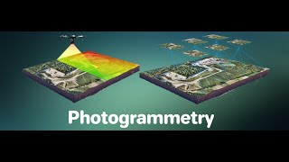
UAV-Based Photogrammetry
Enroll to start learning
You’ve not yet enrolled in this course. Please enroll for free to listen to audio lessons, classroom podcasts and take practice test.
Interactive Audio Lesson
Listen to a student-teacher conversation explaining the topic in a relatable way.
Introduction to UAV-Based Photogrammetry
🔒 Unlock Audio Lesson
Sign up and enroll to listen to this audio lesson

Today, we will learn about UAV-based photogrammetry. Can anyone explain what UAVs are?

UAVs are unmanned aerial vehicles, like drones, used to take aerial photographs.
Exactly! UAVs play a crucial role in capturing high-resolution data. Why do you think they're preferred over traditional methods?

They are cheaper, more flexible, and can access hard-to-reach places.
Great points! Remember the acronym *F.A.C.E* to help you recall these advantages: Flexibility, Affordability, Capability in challenging environments, and Ease of use.

What about accuracy? Are they still as accurate as traditional equipment?
Good question! With proper flight planning and ground control, they can achieve remarkable accuracy, sometimes even surpassing traditional methods.
In summary, UAVs have revolutionized photogrammetry by providing cost-effective, flexible solutions for civil engineering projects.
Components of a UAV System
🔒 Unlock Audio Lesson
Sign up and enroll to listen to this audio lesson

Next, let's discuss the components of a UAV system. What do you think makes up these systems?

I think there is the drone itself and some sort of camera.
You're on the right track! The main components include the drone platform, onboard sensors, a ground control station, and GNSS/IMU systems for accurate georeferencing. Can someone explain the purpose of onboard sensors?
They capture different types of data, like RGB images or thermal images.
Exactly! Sensors provide diverse data types for various applications, from vegetation assessment to thermal imaging. Now, what about the Ground Control Station?
Isn't it used for planning the UAV's flight path and monitoring its performance?
Correct! The GCS is crucial for effective UAV operation. Let's remember the acronym *D.O.G.S* - Drone, Onboard sensors, Ground Control, and Georeferencing systems.
In summary, understanding the components of a UAV system is key to maximizing its potential for accurate data collection.
Advantages in Civil Engineering
🔒 Unlock Audio Lesson
Sign up and enroll to listen to this audio lesson
Let's focus on the advantages of UAVs in civil engineering. Why do you think these benefits matter for professionals in the field?
They save time and money while improving safety on-site.
Exactly! UAVs provide high spatial and temporal resolution, allowing for quick and detailed data gathering. How does that impact project management?
It helps in monitoring the project's progress in real time and making faster decisions based on current data.
Great insight! Also, UAVs can access difficult areas that traditional methods cannot. For example, steep slopes may pose a risk to human surveyors—how does this safety aspect play a role?
Using drones eliminates the danger of sending people into those risky spots.
Exactly! UAVs enhance safety and efficiency. Remember the acronym *S.A.F.E*: Safety, Accessibility, Flexibility, and Efficiency. In summary, UAVs bring groundbreaking advantages to civil engineering by improving safety and efficiency.
Flight Planning Essentials
🔒 Unlock Audio Lesson
Sign up and enroll to listen to this audio lesson
Now, let's talk about flight planning essentials that are crucial for effective data acquisition. What do you think is the first aspect to consider?
I guess ensuring the right overlaps for images is important?
Absolutely! Optimal forward and side overlaps are critical, as they allow for accurate 3D model generation. What is the typical percentage overlap we should aim for?
I think it's around 60-70% for forward overlaps and 20-30% for side overlaps!
Correct! Excellent recall! Besides overlaps, what else should we consider in flight planning?
We need to choose the right flying altitude based on the GSD!
Yes, the Ground Sampling Distance is vital for ensuring the resolution matches project needs. Finally, what external factors might affect our planning?
Weather, wind conditions, and legal regulations can all affect our flight.
Precisely! Always check conditions before your flight. Let's summarize: proper flight planning includes ensuring overlaps, choosing the right altitude, and considering environmental conditions.
Introduction & Overview
Read summaries of the section's main ideas at different levels of detail.
Quick Overview
Standard
Unmanned Aerial Vehicles (UAVs), or drones, have transformed aerial photogrammetry with their affordability, versatility, and capability to capture detailed, high-resolution data. This advancement facilitates efficient data gathering for various civil engineering projects by allowing access to difficult areas and enabling real-time monitoring.
Detailed
UAV-Based Photogrammetry
UAV-based photogrammetry refers to the use of drones in capturing aerial photographs for data acquisition. UAVs have become essential in modern civil engineering applications due to their flexibility, cost effects, and ability to obtain high-resolution data quickly and efficiently.
1. Components of a UAV System
The essential components of a UAV system include:
- Drone Platform: Can be multirotor (for agility and hovering) or fixed-wing (for longer flights).
- Onboard Sensors: Various sensors such as RGB cameras for standard photography, multispectral for vegetation health assessment, thermal sensors for heat data, or LiDAR for topographical mapping.
- Ground Control Station (GCS): Facilitates flight planning, allows real-time monitoring, and data collection.
- GNSS/IMU Systems: Ensures high-accuracy georeferencing of the data collected, which is crucial for reliable mapping outcomes.
2. Advantages in Civil Engineering
UAVs offer numerous benefits in the context of civil engineering, including:
- High Spatial and Temporal Resolution: Captures fine details and allows monitoring changes over time.
- Access to Challenging Areas: Drones can reach steep, hazardous terrains that would be difficult to survey using traditional methods.
- Real-Time Monitoring: Enables immediate assessment and decision-making during project phases.
3. Flight Planning Essentials
Careful flight planning is necessary for successful data acquisition:
- Optimal Overlaps: Ensuring adequate forward and side overlaps (typically around 60-70% and 20-30%, respectively) aids in creating accurate 3D models.
- Flight Altitude: Determining an appropriate altitude based on the desired Ground Sampling Distance (GSD).
- Environmental Considerations: Factors such as weather conditions, wind speed, lighting, and legal regulations (like DGCA guidelines in India) affect flight safety and data quality.
Youtube Videos


![What is MSc Geoinformatics course? – [Hindi] – Quick Support](https://img.youtube.com/vi/QC6cEfNk1aQ/mqdefault.jpg)


Audio Book
Dive deep into the subject with an immersive audiobook experience.
Overview of UAVs in Photogrammetry
Chapter 1 of 4
🔒 Unlock Audio Chapter
Sign up and enroll to access the full audio experience
Chapter Content
Unmanned Aerial Vehicles (UAVs), also known as drones, have become powerful tools in aerial photogrammetry due to their affordability, flexibility, and ability to capture high-resolution data.
Detailed Explanation
UAVs have transformed the field of aerial photogrammetry by providing an economical and adaptable approach to capturing images and data from above. Unlike traditional aircraft or helicopters that may be costly and less accessible, drones can be operated at a fraction of the cost while still offering high image resolution. This means that many more projects can utilize UAVs to collect data efficiently, from urban planning to environmental monitoring.
Examples & Analogies
Think of UAVs as the smartphones of photography. Just as smartphones have made photography accessible to everyone and allow us to capture high-quality images without needing professional equipment, drones have democratized aerial photography, making it available for various industries without the need for expensive setups.
Components of a UAV System
Chapter 2 of 4
🔒 Unlock Audio Chapter
Sign up and enroll to access the full audio experience
Chapter Content
• Drone Platform: Multirotor or fixed-wing.
• Onboard Sensors: RGB cameras, multispectral, thermal, or LiDAR.
• Ground Control Station (GCS): For flight planning and real-time monitoring.
• GNSS/IMU Systems: For accurate georeferencing.
Detailed Explanation
A UAV system consists of several critical components that work together to capture and process aerial images accurately. The drone platform can be either multirotor (like quadcopters) or fixed-wing, each having its own advantages depending on the flight duration and area coverage. Onboard sensors can be various types, such as RGB cameras for color images, multispectral cameras for capturing data across different wavelengths, thermal sensors for heat detection, and LiDAR for precise distance measurements. The Ground Control Station is essential for planning the flight path and monitoring the drone's operation in real time, while GNSS (Global Navigation Satellite System) and IMU (Inertial Measurement Unit) enhance the positioning accuracy needed for mapping tasks.
Examples & Analogies
Imagine planning a road trip using a GPS app. The drone is like your car, the onboard sensors are like the camera you bring to capture your trip, and the Ground Control Station is your route planner that helps you avoid traffic and suggests stops along the way. Just as you want to avoid getting lost with a good map and precise navigation, drones need accurate systems to ensure their data collection is reliable.
Advantages of UAVs in Civil Engineering
Chapter 3 of 4
🔒 Unlock Audio Chapter
Sign up and enroll to access the full audio experience
Chapter Content
• High spatial and temporal resolution.
• Easy access to difficult or hazardous areas (steep slopes, construction sites).
• Real-time monitoring of project progress.
Detailed Explanation
UAVs provide significant benefits in civil engineering by delivering images and data that are both spatially and temporally accurate. This means that the resolution of the data (the detail level) is very high, making it suitable for detailed analyses. Moreover, UAVs can fly into areas that are difficult to reach or unsafe for ground crews, such as steep slopes or construction sites, allowing for comprehensive assessments without risking human safety. Additionally, they provide real-time data during projects, helping to keep stakeholders informed and allowing for quick decision-making.
Examples & Analogies
If you think of a construction project as a movie being filmed, UAVs are like camera drones capturing every scene as it unfolds. They give project managers a real-time view without needing to place crews in potentially dangerous locations. Just as directors use drones to capture stunning overhead shots for movies, engineers use UAVs to monitor their projects' progress and ensure everything goes according to plan.
Flight Planning Essentials
Chapter 4 of 4
🔒 Unlock Audio Chapter
Sign up and enroll to access the full audio experience
Chapter Content
• Ensuring optimal forward and side overlaps.
• Choosing flight altitude for desired GSD (Ground Sampling Distance).
• Considering weather, wind, lighting, and legal regulations (DGCA in India).
Detailed Explanation
Flight planning is crucial in UAV-based photogrammetry to ensure that high-quality data is collected effectively. One key aspect is ensuring that images have adequate overlaps (both forward and side) to facilitate the creation of 3D models. The flight altitude also plays a significant role because it affects the Ground Sampling Distance (GSD), which determines the level of detail in the captured images. Additionally, operators must consider various external factors such as weather conditions, wind speed, lighting for image quality, and legal regulations, such as those set by the Directorate General of Civil Aviation (DGCA) in India to operate drones safely and legally.
Examples & Analogies
Think of planning a family picnic where you want to capture every moment with great photos. You want to ensure that everyone fits in the pictures and that you have all angles covered—like ensuring overlap in your UAV images. You would also check the weather forecast to avoid rain, similar to how drone operators must ensure weather suitability for safe flights. Just like you ensure you have all permissions for your picnic location, drone pilots must adhere to regulations governing where they can fly.
Key Concepts
-
UAV System: Composed of a drone platform, onboard sensors, a ground control station, and GNSS/IMU systems.
-
Flight Planning: Involves ensuring optimal overlaps, selecting appropriate altitude, and considering environmental factors.
-
Data Acquisition: High-resolution data collection facilitated by UAVs is vital for civil engineering applications.
Examples & Applications
Using drones to conduct surveys of construction sites in real-time and capture progress through aerial imagery.
Employing UAVs with RGB cameras to scan urban environments for infrastructure planning, which provides detailed mapping data.
Memory Aids
Interactive tools to help you remember key concepts
Rhymes
When flying a drone up high, safety and overlaps must comply.
Stories
Imagine a drone named 'Dronie' who helps builders measure and map. Dronie can see areas where people can’t go safely, carrying photos to make everything clear!
Memory Tools
To remember UAV system components, use 'D.O.G.S': Drone, Onboard sensors, Ground Control, and Georeferencing.
Acronyms
Remember the acronym 'S.A.F.E' for UAV advantages
Safety
Accessibility
Flexibility
Efficiency.
Flash Cards
Glossary
- UAV (Unmanned Aerial Vehicle)
An aircraft operated without a pilot on board, commonly known as a drone, used for aerial data collection.
- Ground Control Station (GCS)
A ground-based setup that communicates with the UAV, allowing for flight planning, data collection, and monitoring.
- Ground Sampling Distance (GSD)
A measure of the distance represented by each pixel in the image, affecting image resolution.
- GNSS (Global Navigation Satellite System)
Satellite systems that provide geolocation and time information to a receiver anywhere on Earth.
- IMU (Inertial Measurement Unit)
A device that uses a combination of accelerometers and gyroscopes to provide orientation and position data.
Reference links
Supplementary resources to enhance your learning experience.