
Software Tools for Photogrammetry
Enroll to start learning
You’ve not yet enrolled in this course. Please enroll for free to listen to audio lessons, classroom podcasts and take practice test.
Interactive Audio Lesson
Listen to a student-teacher conversation explaining the topic in a relatable way.
Introduction to Photogrammetry Software
🔒 Unlock Audio Lesson
Sign up and enroll to listen to this audio lesson

Today, we will explore the software tools available for photogrammetry. Why do you think software is essential in this field?

Because it helps in processing images and creating accurate models from them.
Exactly! Software enables us to efficiently convert multiple images into useful spatial data. Now, let's categorize these tools. Can anyone name a commercial photogrammetry software tool?

Agisoft Metashape?
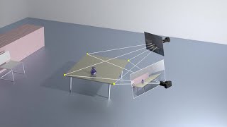
Correct! Metashape is renowned for its dense reconstruction capabilities, among other features. Can anyone tell me what makes it a go-to tool for professionals?

I think it has good Structure from Motion capabilities.
That's right. Its robust SfM technique is critical for creating accurate models. Recapping today's discussion: software improves photogrammetric processes, with Metashape being a key commercial option.
Exploring Open-Source Software Tools
🔒 Unlock Audio Lesson
Sign up and enroll to listen to this audio lesson

Let’s dive into open-source software options. Why might someone prefer using open-source tools for photogrammetry?

They might be more cost-effective and customizable.
Absolutely! Open-source software like OpenDroneMap allows users to customize their processing workflows. Has anyone heard of MicMac?
Yes! It’s supposed to be quite powerful for research, isn’t it?
Exactly! It’s well-suited for advanced photogrammetric tasks. Let’s conclude with key points: open-source tools provide flexibility and customization, important for professionals and researchers alike.
Applications of Commercial vs. Open-Source Software
🔒 Unlock Audio Lesson
Sign up and enroll to listen to this audio lesson
Now that we know some software options, what are some practical applications you see for commercial software like Pix4Dmapper?
I think it would be great for agricultural mapping and planning.
Right! Pix4Dmapper's integration with GIS makes it perfect for that. What about OpenDroneMap?
It can be used in academic settings for research projects.
Exactly! Its versatility in generating models from UAV imagery is invaluable for research. Let’s take away this point: both types of software cater to varying needs — whether commercial or open-source, each tool has its place in photogrammetry.
Introduction & Overview
Read summaries of the section's main ideas at different levels of detail.
Quick Overview
Standard
The section highlights a range of software tools used in photogrammetry, including notable commercial software like Agisoft Metashape and Pix4D, along with open-source alternatives like OpenDroneMap. Each software's primary features and applications in the field are briefly described.
Detailed
Software Tools for Photogrammetry
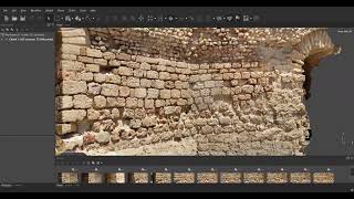
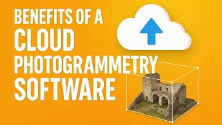
Photogrammetry harnesses a variety of software tools to process images and create spatial data. This section categorizes these tools into two main types: commercial and open-source.
Commercial Software
- Agisoft Metashape: Known for its Structure from Motion (SfM) capabilities, dense reconstruction, and Digital Surface Model (DSM) generation, Agisoft Metashape is widely used in both professional and academic environments.
- Pix4Dmapper: This software specializes in UAV photogrammetry, integrating GIS functionalities to provide seamless mapping solutions tailored for various applications, including agriculture and construction.
- DroneDeploy: A cloud-based platform, DroneDeploy offers mapping capabilities that are accessible and user-friendly, transmitting high-resolution data from UAVs.
Open-Source Software
- OpenDroneMap (ODM): A comprehensive photogrammetry suite that supports processing imagery from UAVs and generates 3D models and maps.
- MicMac: Developed by IGN France, MicMac is a powerful photogrammetric engine that supports research and complex photogrammetric tasks.
- COLMAP: This software offers a robust pipeline for SfM and Multi-View Stereo (MVS), facilitating high-quality 3D reconstruction from images.
Overall, these software tools exemplify the diverse approaches to image processing and analysis in photogrammetry, allowing users to select a solution that best addresses their specific needs.
Youtube Videos


Audio Book
Dive deep into the subject with an immersive audiobook experience.
Overview of Software Tools
Chapter 1 of 3
🔒 Unlock Audio Chapter
Sign up and enroll to access the full audio experience
Chapter Content
A range of commercial and open-source software is available for photogrammetric processing.
Detailed Explanation
This chunk provides a broad overview of the types of software available for photogrammetry. It indicates that there are various options for both commercial and open-source software, catering to different user needs and budget constraints.
Examples & Analogies
Think of this like shopping for a computer program, where you can choose between paid premium options that might include customer support and extra features, or free options that provide similar functions. For example, some students might buy Microsoft Office for its user-friendly interface and support, while others may prefer the free option of Google Docs, which is accessible from anywhere.
Commercial Software Tools
Chapter 2 of 3
🔒 Unlock Audio Chapter
Sign up and enroll to access the full audio experience
Chapter Content
- Agisoft Metashape: SfM, dense reconstruction, and DSM generation.
- Pix4Dmapper: UAV photogrammetry and GIS integration.
- DroneDeploy: Cloud-based mapping and modeling platform.
Detailed Explanation
This chunk lists specific commercial software tools that are commonly used in photogrammetry. Each software tool offers unique features:
- Agisoft Metashape: Specializes in Structure from Motion (SfM) and creating dense 3D models (Digital Surface Models).
- Pix4Dmapper: Widely used for processing imagery collected by drones and integrating this data with Geographic Information Systems (GIS).
- DroneDeploy: A cloud-based service that allows users to create maps and models through a user-friendly online platform.
Examples & Analogies
Imagine a chef having a range of specialized kitchen tools for different tasks. Just like a chef might use a blender for smoothies and a knife for chopping vegetables, a photogrammetrist uses tools like Agisoft Metashape for intricate data reconstruction or DroneDeploy for quick and efficient mapping.
Open-Source Software Tools
Chapter 3 of 3
🔒 Unlock Audio Chapter
Sign up and enroll to access the full audio experience
Chapter Content
- OpenDroneMap (ODM): Full-featured UAV photogrammetry suite.
- MicMac (IGN France): Advanced photogrammetric engine for research use.
- COLMAP: SfM and MVS pipeline for high-quality 3D reconstruction.
Detailed Explanation
This chunk describes several open-source software options for photogrammetry. Each of these tools provides valuable features:
- OpenDroneMap (ODM) is designed for processing aerial imagery from drones and produces various outputs for 3D modeling.
- MicMac is a more advanced option typically used in research settings, offering depth and sophistication for photogrammetric tasks.
- COLMAP is known for its high-quality reconstruction capabilities, employing Structure from Motion and Multi-View Stereo techniques.
Examples & Analogies
Imagine you're part of a DIY enthusiast community where members build their projects using both purchased and homemade tools. In this scenario, open-source software acts like a toolbox where each member shares their innovations and creations, allowing everyone to benefit from detailed, high-quality tools without the costs associated with commercial products.
Key Concepts
-
Commercial Software: Tools like Agisoft Metashape and Pix4D tailored for professional use, providing specialized features for photogrammetric tasks.
-
Open-Source Software: Options such as OpenDroneMap and MicMac that allow customization and flexibility, catering to academic and research needs.
Examples & Applications
Agisoft Metashape is often used in topographic mapping for civil engineering projects.
MicMac could be utilized by researchers studying historical sites to create detailed 3D models.
Memory Aids
Interactive tools to help you remember key concepts
Rhymes
For mapping your scene, choose the best machine, Agisoft or Pix4D, where all paths are seen.
Stories
Once, a researcher named MicMac explored the open-source realm, finding a treasure of tools to shape and model landscapes, while a farmer deployed drone mapping, unveiling his crops’ dreams.
Memory Tools
Remember 'P.A.D.O.M.' for your software categories: Pix4D, Agisoft, DroneDeploy, OpenDroneMap, MicMac.
Acronyms
The acronym 'CAD-MAP' stands for Commercial Applications using Drone-Mapping And Photogrammetry.
Flash Cards
Glossary
- Agisoft Metashape
A commercial software used for photogrammetric processing and 3D modeling.
- Pix4Dmapper
Commercial software that specializes in UAV photogrammetry and integrates GIS functionalities.
- DroneDeploy
A cloud-based platform for mapping and modeling in photogrammetry.
- OpenDroneMap (ODM)
Full-featured open-source software for UAV photogrammetry.
- MicMac
An advanced open-source photogrammetric engine used mainly in research.
- COLMAP
Open-source software for Structure from Motion (SfM) and Multi-View Stereo (MVS) processing.
Reference links
Supplementary resources to enhance your learning experience.