
Geometry of Aerial Photographs
Enroll to start learning
You’ve not yet enrolled in this course. Please enroll for free to listen to audio lessons, classroom podcasts and take practice test.
Interactive Audio Lesson
Listen to a student-teacher conversation explaining the topic in a relatable way.
Types of Aerial Photographs
🔒 Unlock Audio Lesson
Sign up and enroll to listen to this audio lesson

Let's explore the types of aerial photographs! We have vertical photographs that capture images straight down. Why do you think these are essential for mapping?

Because they minimize distortion and provide accurate measurements!
Exactly! Vertical photographs are crucial for precise mapping. Now, what about oblique photographs? Can anyone tell me the differences between low and high obliques?

Low oblique photographs show a smaller angle, while high oblique photographs show more of the background.
Correct! Knowing these differences helps us decide which type to use for specific applications.

So, vertical is for accuracy, and oblique is for context?
That's a great summary! Remember: Vertical for detail, oblique for a broader view.
Scale of Aerial Photographs
🔒 Unlock Audio Lesson
Sign up and enroll to listen to this audio lesson

Next, let's talk about the scale of aerial photographs. Who can share the formula for calculating it?

It’s scale equals the focal length divided by the flying height minus the average ground elevation!
Perfect! Can anyone explain why the average ground elevation is included in that formula?
It helps adjust the scale according to the terrain's height, ensuring accuracy in measurements!
Well said! The terrain height significantly affects how we interpret images.
Relief Displacement
🔒 Unlock Audio Lesson
Sign up and enroll to listen to this audio lesson
Now let’s analyze relief displacement. What does it mean when we say there’s vertical displacement of objects in photographs?
It means that objects at different elevations appear to shift away from their actual positions!
Exactly! Relief displacement can cause substantial errors in distance measurements. How does this affect our interpretation of aerial images?
We might misinterpret an object's location or its dimensions if we don’t account for that displacement!
Yes! Always factor in elevation differences for accurate data extraction.
Introduction & Overview
Read summaries of the section's main ideas at different levels of detail.
Quick Overview
Standard
The section elaborates on the importance of understanding the geometry of aerial images in photogrammetry, detailing various types of aerial photographs, how to compute their scale, and the concept of relief displacement, which is essential for extracting accurate spatial information.
Detailed
Geometry of Aerial Photographs
Understanding the geometry of aerial photographs is fundamental for accurately extracting spatial information utilized in various applications such as mapping and surveying. This section categorically breaks down the types of aerial photographs into vertical and oblique types, where vertical photographs are taken with the camera axis pointing straight down and are ideal for mapping tasks, while oblique photographs capture angles and are useful for broader contextual assessments.
Types of Aerial Photographs
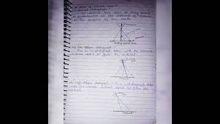
- Vertical Photographs: The camera is oriented perpendicular to the ground, resulting in less distortion and making them perfect for cartographic applications.
- Oblique Photographs: These capture images at an angle, which can be further divided into low oblique and high oblique photographs based on the angle of view, offering different perspectives but increased complexity in measurements.
Scale of a Photograph
To determine the scale of an aerial photograph, the formula used is:
Scale = Focal Length (f) / (Flying Height (H) − Average Ground Elevation (h))
This formula highlights the relationship between the photograph's focal length and the actual height above the ground, allowing photogrammetrists to understand how the scale varies with elevation.
Relief Displacement
Relief displacement explains how objects appear displaced from their true positions due to differences in their elevation. This occurs radially from the principal point, emphasizing the importance of terrain relief in accurately interpreting aerial images.
In conclusion, the geometrical understanding of aerial photographs allows for more precise data extraction, which is pivotal in civil engineering and related fields.
Youtube Videos


Audio Book
Dive deep into the subject with an immersive audiobook experience.
Types of Aerial Photographs
Chapter 1 of 1
🔒 Unlock Audio Chapter
Sign up and enroll to access the full audio experience
Chapter Content
• Vertical Photographs: Camera axis is vertical to the ground; used for mapping.
• Oblique Photographs: Camera axis inclined; further classified as low or high oblique.
Detailed Explanation
In aerial photography, there are two main types of photographs based on how the camera is positioned:
1. Vertical Photographs: Here, the camera is directly above the ground, looking straight down. This orientation is ideal for creating detailed maps as it gives an accurate representation of distances and areas on the ground.
2. Oblique Photographs: These are taken when the camera is tilted at an angle, looking across the landscape rather than straight down. Oblique photographs can be further categorized into low oblique and high oblique. Low oblique photos typically show more ground detail, while high oblique photos capture more of the horizon and are useful for showcasing the landscape in its context.
- Chunk Title: Scale of a Photograph
- Chunk Text: Focal Length (f)
Scale=
Flying Height (H)−Average Ground Elevation (h)
- Detailed Explanation: The scale of an aerial photograph determines how distances in the photograph relate to actual distances on the ground. It is defined using the formula:
Scale = Focal Length (f) / (Flying Height (H) - Average Ground Elevation (h))
This formula indicates that the scale is influenced by two main factors: the focal length of the camera lens and the height at which the camera is flying above the ground terrain. A larger scale indicates a closer view showing more detail, whereas a smaller scale suggests a broader view but less detail.
- Chunk Title: Relief Displacement
- Chunk Text: • Vertical displacement of objects due to elevation differences.
• Radial displacement from the principal point outward.
- Detailed Explanation: Relief displacement refers to the way objects appear in a photograph due to their elevation above the ground. There are two main effects to understand:
1. Vertical Displacement: This occurs because higher objects, like trees or buildings, appear farther away from the camera than lower ones. Therefore, in a photo, taller structures may seem shifted from their true position compared to flat terrain.
2. Radial Displacement: This outward displacement occurs from the principal point (the point directly below the camera) — objects farther away from this point appear more displaced in the image than those that are closer.
Examples & Analogies
Key Concepts
-
Types of Aerial Photographs: Vertical and oblique photographs serve different purposes for mapping and analysis.
-
Scale of Aerial Photographs: It is determined using focal length and flying height, essential for accurate interpretation.
-
Relief Displacement: Vertical displacement occurs due to elevation differences, impacting measurements and interpretations.
Examples & Applications
Vertical photographs are commonly used in topographic mapping to create accurate 2D representations of the terrain.
Oblique photographs may be useful in urban planning for assessing the height and layout of buildings.
Memory Aids
Interactive tools to help you remember key concepts
Rhymes
Vertical views make maps align, oblique views frame a scene so fine.
Stories
Imagine a photographer standing on a tall tower taking a picture straight down; this is a vertical photo. Nearby, a friend is taking a picture at an angle to show not only the building but the garden too—this is an oblique photo.
Memory Tools
To remember the scale formula, think F-H-A: Focal length minus Height equals Average ground level.
Acronyms
V for Vertical images are Vital for mapping; O for Oblique images offer Overall views.
Flash Cards
Glossary
- Vertical Photograph
Aerial image taken with the camera axis vertical to the ground, providing minimal distortion.
- Oblique Photograph
Aerial image captured at an angle, offering a perspective view, which includes both low and high oblique types.
- Scale
The ratio of distance on the photograph to distance on the ground, calculated using focal length and flying height.
- Relief Displacement
Vertical displacement of objects in aerial photographs due to differences in elevation.
Reference links
Supplementary resources to enhance your learning experience.