
Data Formats, Compression, and Storage
Enroll to start learning
You’ve not yet enrolled in this course. Please enroll for free to listen to audio lessons, classroom podcasts and take practice test.
Interactive Audio Lesson
Listen to a student-teacher conversation explaining the topic in a relatable way.
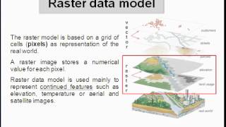
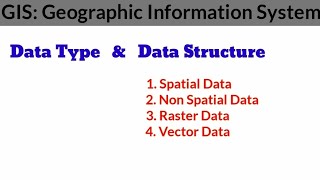
Raster Image Formats
🔒 Unlock Audio Lesson
Sign up and enroll to listen to this audio lesson

Today, let’s start with raster image formats. Can anyone tell me what they understand by raster images?

I think they are images represented by a grid of pixels.
Exactly! Formats like GeoTIFF, HDF, and NetCDF are crucial because they contain not just image data but also vital metadata. For instance, GeoTIFF includes geographic data, making it essential for GIS applications. Remember, 'Geo' in GeoTIFF stands for Geo-referencing!

What other formats do we need to know about?
Other important formats include IMG and HDF. HDF stands for Hierarchical Data Format, which allows for the growth of the data structure while being versatile. Keep that in mind!
Compression Techniques
🔒 Unlock Audio Lesson
Sign up and enroll to listen to this audio lesson

Next, let’s talk about compression techniques. Why do you think compression is necessary for satellite images?

To save storage space, right?
Exactly! We can utilize lossless compression, like DEFLATE, which keeps the data intact. Or we can go with lossy compression, such as JPEG 2000, which reduces quality but saves more space. Can anyone remember the key trade-off between these two methods?

Lossless maintains quality, but lossy uses less space!
Great job! Balancing quality and space is crucial. Remember, choose wisely based on your project needs!
Data Storage and Management
🔒 Unlock Audio Lesson
Sign up and enroll to listen to this audio lesson
Now, let’s focus on data storage and management. Why is it important to have a good storage system for satellite imagery?
Because we deal with a lot of data, right?
Yes! Solutions like spatial databases and cloud storage are key. They help us manage large datasets efficiently. Can anybody give an example of how we might use GIS with satellite images?
We could analyze land use changes by overlaying satellite images on GIS layers.
Precisely! Leveraging GIS allows for comprehensive data analysis and decision-making in numerous applications. Remember to integrate effectively!
Introduction & Overview
Read summaries of the section's main ideas at different levels of detail.
Quick Overview
Standard
In this section, we explore different raster image formats like GeoTIFF and NetCDF, the implications of lossless versus lossy compression techniques, and the best practices for data storage and management in the context of satellite imagery processing.
Detailed
Data Formats, Compression, and Storage
In the world of satellite image processing, effective handling of imagery data necessitates understanding various data formats, compression methods, and storage strategies. This section delves into three primary domains:
Raster Image Formats
Raster image formats, including GeoTIFF, IMG, HDF, and NetCDF, play a crucial role in managing satellite data. These formats not only store image data but also embed geo-referencing information and metadata, which are essential for accurate location plotting and further analysis. For instance, GeoTIFF is widely used due to its support for geographic metadata, making it a preferred format for geospatial applications.
Compression Techniques
The efficient storage of large satellite datasets leads to the need for compression techniques. There are two main types:
- Lossless Compression (e.g., LZW, DEFLATE): This method preserves original image quality while reducing file size, ideal for applications where data integrity is paramount.
- Lossy Compression (e.g., JPEG 2000): Though it reduces file size significantly, this method may result in the loss of some image quality. Users must weigh the trade-offs between storage efficiency and image fidelity based on their specific needs.
Data Storage and Management
Effective storage and management solutions are imperative for big image datasets. Spatial databases and cloud storage systems provide scalable options for handling vast amounts of satellite data. Integration with Geographic Information Systems (GIS) allows for seamless visualization and analysis, further enhancing decision-making processes across various applications, such as urban development and disaster management.
Youtube Videos


Audio Book
Dive deep into the subject with an immersive audiobook experience.
Raster Image Formats
Chapter 1 of 3
🔒 Unlock Audio Chapter
Sign up and enroll to access the full audio experience
Chapter Content
- GeoTIFF, IMG, HDF, NetCDF formats.
- Geo-referencing and metadata embedded.
Detailed Explanation
Raster image formats are essential for storing satellite imagery. These formats include GeoTIFF, IMG, HDF, and NetCDF. Each format has its own features, but they all support geo-referencing, which means that they provide spatial reference information about the image data. This ensures that the imagery can be accurately located on the earth's surface. Additionally, metadata embedded in these formats contains essential information about the data, such as the date of acquisition, sensor type, and processing details, making it easier to manage and analyze.
Examples & Analogies
Think of raster image formats as different types of containers for food. Just like some containers are designed to keep food fresh with labels about the expiration date (metadata), raster image formats keep satellite data organized with geo-referencing to ensure we know exactly where on the globe that data comes from.
Compression Techniques
Chapter 2 of 3
🔒 Unlock Audio Chapter
Sign up and enroll to access the full audio experience
Chapter Content
- Lossless (e.g., LZW, DEFLATE) and lossy (e.g., JPEG 2000) compression.
- Trade-offs between storage size and image quality.
Detailed Explanation
Compression techniques are used to reduce the file size of satellite images for easier storage and quicker transmission. There are two main types of compression: lossless and lossy. Lossless compression retains all the original data and allows for exact recovery of the original image, using methods like LZW and DEFLATE. On the other hand, lossy compression reduces file size by permanently eliminating some image data, which can affect quality, such as in JPEG 2000. The choice between these methods often involves a trade-off; while lossless compression preserves image quality, it leads to larger file sizes. Conversely, lossy compression significantly reduces file size at the risk of some quality loss.
Examples & Analogies
Imagine packing a suitcase for a trip. Using lossless compression is like folding clothes neatly and efficiently so that everything fits without damaging the clothes, while lossy compression is like rolling up clothes tightly and removing a few items to get the suitcase to close—it's smaller and lighter, but you might lose something important!
Data Storage and Management
Chapter 3 of 3
🔒 Unlock Audio Chapter
Sign up and enroll to access the full audio experience
Chapter Content
- Use of spatial databases and cloud storage solutions for big image datasets.
- Integration with GIS platforms for visualization and analysis.
Detailed Explanation
Data storage and management are crucial for handling large datasets from satellite imagery. Spatial databases are designed to store and query spatial data, making them ideal for raster and vector imagery. Cloud storage solutions also provide scalable options for storing big datasets, enabling access anytime and from anywhere. When these datasets are integrated with Geographic Information Systems (GIS) platforms, users can visualize the data effectively and perform various analyses, such as mapping, spatial queries, and change detection over time.
Examples & Analogies
Consider data storage and management like maintaining a library. A spatial database is akin to a well-organized library where every book (image) is easy to find based on its topic (location). Additionally, cloud storage is like having a digital library that allows people to access books from anywhere in the world. When combined with GIS, it’s like having a librarian to help you pull together different resources to explore various subjects (performing analyses) more effectively.
Key Concepts
-
Raster Image Formats: Essential file formats for storing satellite imagery data, including metadata for geo-referencing.
-
Compression Techniques: Methods (lossy and lossless) that serve to reduce file size, impacting quality.
-
Data Management: Strategies and technologies for efficiently storing and handling large datasets.
Examples & Applications
GeoTIFF format is widely used for satellite imagery as it contains intrinsic metadata allowing it to be used across GIS platforms.
Lossy compression is used in applications prioritizing file size over image fidelity, like online maps.
Memory Aids
Interactive tools to help you remember key concepts
Rhymes
GeoTIFF has data that's neat, with geo-info it can’t be beat.
Memory Tools
Remember: LCd for compression - Lossy Costs detail, Lossless Keeps detail.
Stories
Picture a library. GeoTIFF is like a librarian who knows exactly where each book belongs, making it easy to find.
Acronyms
GCR for storage solutions – Geographic, Cloud, Reliable.
Flash Cards
Glossary
- GeoTIFF
A public domain metadata standard which allows georeferencing information to be embedded within the TIFF file.
- Compression
The process of reducing the size of data to save storage space.
- Lossless Compression
Data compression that allows the original data to be perfectly reconstructed from the compressed data.
- Lossy Compression
Data compression that removes some data to reduce file size, potentially affecting quality.
- Spatial Database
A database that is optimized to store and query data related to space, including satellite images.
Reference links
Supplementary resources to enhance your learning experience.