
Image Enhancement Techniques
Enroll to start learning
You’ve not yet enrolled in this course. Please enroll for free to listen to audio lessons, classroom podcasts and take practice test.
Interactive Audio Lesson
Listen to a student-teacher conversation explaining the topic in a relatable way.
Contrast Stretching
🔒 Unlock Audio Lesson
Sign up and enroll to listen to this audio lesson

Let's begin with contrast stretching. This technique enhances the contrast of an image by adjusting the intensity levels. Can anyone think of why contrast is significant in images?

I think it helps to differentiate between different features more clearly!
Exactly! A clear contrast allows us to distinguish features that might otherwise blend together. One method of contrast stretching is histogram equalization. Can anyone explain what that involves?

It redistributes the image's intensity values to cover the full range, right?
Yes! Well done. Remember, a good way to recall this is that histogram equalization 'equalizes' the appearance, like giving every feature a fair chance to show its colors!

Could you give us an example of when this would be useful?
Certainly! Contrast stretching is vital when analyzing images taken under varying lighting conditions. By adjusting the contrast, we help ensure that details are not lost. It's often used in urban planning where clear distinctions between land cover types are critical.
Spatial Filtering
🔒 Unlock Audio Lesson
Sign up and enroll to listen to this audio lesson

Let's move on to spatial filtering. Who can tell me what we might achieve with spatial filtering?

I believe it helps to emphasize edges and features, right?
Correct! High-pass filters emphasize the edges by enhancing high-frequency details, while low-pass filters smooth out details and reduce noise. Why do you think smoothing might be necessary?
Smoothing could help to clean up images before further analysis?
Absolutely! Always think of it as preparing your canvas for clearer insights. A way to remember the function of these filters is to visualize high-pass filters as a magnifying glass that clarifies edges, while low-pass filters act like a soft blur to hide distractions.
Can we apply both types of filters on the same image?
Great question! Yes, often both filters can be used sequentially to enhance an image for detailed analysis. It's a perfect blend of clarity and coherence!
Band Ratioing
🔒 Unlock Audio Lesson
Sign up and enroll to listen to this audio lesson
Now let's discuss band ratioing—a unique technique that enhances specific features. What do we mean by this?
Isn't it about dividing one band by another—like how NDVI works for vegetation?
Exactly! The NDVI uses the difference in reflectance between the near-infrared and red bands to assess vegetation health. Think of it this way: Higher values indicate healthy vegetation. How does this technique compare to other enhancement methods we've discussed?
I think it's more targeted—it focuses specifically on the vegetation rather than general improvements.
Spot-on! Band ratioing works well when you're keen on analyzing specific land cover types, making it highly effective for ecological studies.
Principal Component Analysis (PCA)
🔒 Unlock Audio Lesson
Sign up and enroll to listen to this audio lesson
Finally, let's explore Principal Component Analysis, or PCA. Can someone share what PCA does in image processing?
It reduces dimensionality in the data to highlight variations among different land covers.
Great summary! By reducing redundancy, PCA helps us simplify analysis. Can you all imagine a situation where reduced data complexity would be beneficial?
When classifying land cover types! It would make it easier to identify patterns!
Absolutely! This is why PCA is a powerful tool in remote sensing; you can increase processing efficiency while gaining relevant insights. A mnemonic to remember PCA's purpose is 'Peak Clarity Always,' emphasizing that we want the clearest insights from our data.
Introduction & Overview
Read summaries of the section's main ideas at different levels of detail.
Quick Overview
Standard
In this section, we explore several critical image enhancement techniques, including contrast stretching, spatial filtering, band ratioing, and principal component analysis (PCA), which are essential for improving the usability of satellite imagery in various applications.
Detailed
Image Enhancement Techniques
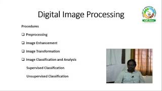
Image enhancement techniques play a crucial role in improving the visual quality and interpretability of satellite imagery. The effectiveness of remote sensing applications relies heavily on how well images are processed and enhanced. Here, we outline four primary techniques:
- Contrast Stretching:
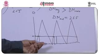
- This technique can be linear or nonlinear and is designed to enhance the contrast in the image. By adjusting the range of intensity levels within the image, we can significantly improve visibility. A commonly used method under this category is histogram equalization, which redistributes the image’s intensity values to cover the entire display range.
- Spatial Filtering:
- Spatial filtering techniques aim to emphasize specific features within the image, such as edges or lines. High-pass filters are used to enhance edges by boosting high-frequency components, while low-pass filters help to smooth the image by reducing the noise present.
- Band Ratioing:
- This method enhances specific features by creating a ratio of the intensities of two or more spectral bands. For example, the Normalized Difference Vegetation Index (NDVI) uses red and near-infrared bands to identify vegetation health by measuring the differences in reflectance.
- Principal Component Analysis (PCA):
- PCA is a technique used to reduce dimensionality in datasets, particularly those involving multispectral imagery. By transforming the data, PCA can highlight variations between different land cover types, making classification easier and more effective.
These techniques collectively enhance image quality, making satellite data more useful for environmental monitoring, urban planning, agricultural studies, and other applications.
Youtube Videos


Audio Book
Dive deep into the subject with an immersive audiobook experience.
Contrast Stretching
Chapter 1 of 4
🔒 Unlock Audio Chapter
Sign up and enroll to access the full audio experience
Chapter Content
Contrast Stretching
• Linear or nonlinear methods used to enhance image contrast.
• Histogram equalization is a common technique.
Detailed Explanation
Contrast stretching is a method used to improve the visibility of certain features in images. By adjusting the range of intensity values, we can enhance the differences between light and dark areas. There are two main types of methods: linear and nonlinear. Linear contrast stretching uniformly distributes the intensity values, while nonlinear methods may adjust according to the distribution of pixel values. Histogram equalization is one specific nonlinear technique that aims to make the histogram of an image more uniform, effectively redistributing pixel values to use the available range more effectively.
Examples & Analogies
Think of contrast stretching like adjusting the brightness and contrast of a photograph. When you take a picture, it might look dull if the colors and tones are too close together. By enhancing the contrast, just like using photo editing software, you make the lights brighter and the darks darker, making key details stand out more clearly.
Spatial Filtering
Chapter 2 of 4
🔒 Unlock Audio Chapter
Sign up and enroll to access the full audio experience
Chapter Content
Spatial Filtering
• Employed to highlight specific features (edges, lines).
• High-pass filters emphasize edges, while low-pass filters smooth the image.
Detailed Explanation
Spatial filtering is a technique used to modify or enhance an image's details based on the spatial arrangement of pixels. High-pass filters are used to emphasize features such as edges and detailed shapes by allowing high-frequency components (sharp transitions) to pass through while blocking lower-frequency ones (smooth areas). Conversely, low-pass filters smooth an image by averaging neighboring pixel values, effectively reducing the noise and focusing on general patterns instead of fine details.
Examples & Analogies
Imagine you are drawing a picture. If you want to emphasize the outline of a character or object, you might use a darker pencil to trace around it—this is similar to using a high-pass filter. On the other hand, if you want to create a soft background with no sharp details, you might smear the colors together—this is comparable to applying a low-pass filter which smooths out the image.
Band Ratioing
Chapter 3 of 4
🔒 Unlock Audio Chapter
Sign up and enroll to access the full audio experience
Chapter Content
Band Ratioing
• Enhances specific features by dividing one spectral band by another (e.g., NDVI for vegetation).
Detailed Explanation
Band ratioing involves calculating the ratio of two different spectral bands to highlight specific features in an image. This technique is commonly used in remote sensing data, where different materials reflect light differently across various wavelengths. A well-known example is the Normalized Difference Vegetation Index (NDVI), which uses the near-infrared and red bands to quantify vegetation health and density, where healthy vegetation reflects more near-infrared light compared to unhealthy vegetation.
Examples & Analogies
Think of band ratioing as using a special filter to see how green a plant is compared to the surrounding soil. If you were a gardener, by looking through these special glasses (like using the NDVI), you could see which plants are thriving and which ones need more water based on their color differences.
Principal Component Analysis (PCA)
Chapter 4 of 4
🔒 Unlock Audio Chapter
Sign up and enroll to access the full audio experience
Chapter Content
Principal Component Analysis (PCA)
• Reduces dimensionality and redundancy in multispectral data.
• Highlights variations among land cover types.
Detailed Explanation
Principal Component Analysis (PCA) is a statistical technique used to reduce the dimensions of a dataset while retaining most of its variation. In satellite imagery, PCA works by transforming the original multispectral images into a new set of uncorrelated variables (the principal components). This helps in simplifying the complexity of the data, focusing on the most significant variations, and effectively reducing redundancy caused by highly correlated bands. This technique is especially useful to differentiate land cover types based on subtle spectral differences.
Examples & Analogies
Imagine you are packing your suitcase for a trip. Instead of taking every piece of clothing, you select versatile items that can be mixed and matched—this is like PCA, which keeps the most important information while getting rid of the redundancy (similar items) to simplify your packing. It lets you focus on the most important aspects of your wardrobe (or in this case, the dataset).
Key Concepts
-
Contrast Stretching: Enhancing visual contrast in images for better feature distinction.
-
Spatial Filtering: Emphasizing specific features using filters to improve image analysis.
-
Band Ratioing: Targeted enhancement of features by creating ratios of different spectral bands.
-
Principal Component Analysis (PCA): A technique for reducing the complexity of multispectral data while retaining essential information.
Examples & Applications
Using contrast stretching to enhance a low-light satellite image of urban areas making the features more distinguishable.
Applying band ratioing to identify stressed vegetation by employing NDVI calculations based on reflectance from NIR and red wavelengths.
Memory Aids
Interactive tools to help you remember key concepts
Rhymes
To stretch the contrast, give it a chance, let colors leap out, make the details dance!
Stories
Imagine a painter with a wide palette. They first stretch the colors to make the bright hues pop, and with a soft brush, they smooth out the details, revealing a masterpiece that everyone admires.
Memory Tools
Remember the acronym 'C-S-B-P' for Contrast Stretching, Spatial Filtering, Band Ratioing, and PCA!
Acronyms
PCA
'People Can Analyze'—indicating its role in helping us simplify and analyze data effectively.
Flash Cards
Glossary
- Contrast Stretching
A technique used to enhance the contrast of an image by adjusting the range of intensity levels.
- Spatial Filtering
Techniques employed to enhance specific features in an image, such as edges or lines, using high-pass or low-pass filters.
- Band Ratioing
A method to enhance specific features by dividing one spectral band by another.
- Principal Component Analysis (PCA)
A technique that reduces the dimensionality of multispectral data to highlight variations in land cover types.
Reference links
Supplementary resources to enhance your learning experience.