
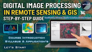
Satellite Image Processing
Enroll to start learning
You’ve not yet enrolled in this course. Please enroll for free to listen to audio lessons, classroom podcasts and take practice test.
Interactive Audio Lesson
Listen to a student-teacher conversation explaining the topic in a relatable way.
Types of Satellite Sensors
🔒 Unlock Audio Lesson
Sign up and enroll to listen to this audio lesson

Today, we'll be discussing the two main types of satellite sensors: passive and active sensors. Can anyone tell me what a passive sensor does?

A passive sensor uses natural radiation like sunlight, right?
Correct! Passive sensors indeed rely on natural light for data collection. Now, does anyone know an example of a passive sensor?

What about optical sensors like Landsat?
Exactly! Optical sensors are a type of passive sensor. Now, let’s move to active sensors. What distinguishes active sensors from passive ones?

Active sensors emit their own signals and measure the reflected waves.
Great! An example would be Synthetic Aperture Radar or LiDAR. Remember the acronym 'SAR'. Can anyone think of a scenario where each type might be preferred?

We would use passive sensors for general imagery during the day, but active ones for detailed topographic surveys in cloudy weather!
Well said! To summarize, passive sensors depend on natural light, while active sensors create their own signals for data collection. Keep this in mind as we continue to explore the nuances of satellite imagery.
Image Acquisition and Preprocessing Techniques
🔒 Unlock Audio Lesson
Sign up and enroll to listen to this audio lesson

Next, let's dive into image acquisition and preprocessing techniques. Why do you think preprocessing is necessary before analyzing satellite images?
To correct any errors or distortions, I guess!
Exactly. Radiometric correction corrects sensor irregularities and atmospheric interference. Now, who can explain geometric correction?
Isn't that about aligning images to real-world coordinates using Ground Control Points?
Perfect! It ensures our data reflects true positions on Earth. Let's not forget atmospheric correction, which eliminates scattering effects. Can anyone recall a method for atmospheric correction?
Dark Object Subtraction (DOS) is one of them!
Well done! And noise reduction is crucial too. What can we use to filter out noise?
I believe Median and Gaussian filters can help?
Exactly! To summarize, preprocessing techniques like radiometric, geometric, and atmospheric corrections, along with noise reduction, are essential to prepare quality data for analysis.
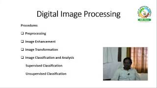
Image Classification Techniques
🔒 Unlock Audio Lesson
Sign up and enroll to listen to this audio lesson
Now we'll explore image classification techniques. Can anyone explain the difference between supervised and unsupervised classification?
Supervised classification uses user-defined training data, while unsupervised classification doesn't require it.
Correct! Can you name an algorithm used in supervised classification?
Maximum Likelihood is one of them, right?
That’s right! What about unsupervised classification? Any algorithms come to mind?
K-means is a popular choice!
Exactly! Lastly, can anyone explain OBAI, or Object-Based Image Analysis?
It segments the image into objects for better classification!
Fantastic! Remember, these classification techniques help us derive meaningful insights from satellite data.
Applications in Civil Engineering
🔒 Unlock Audio Lesson
Sign up and enroll to listen to this audio lesson
Let’s discuss how satellite image processing applies to civil engineering. How do you think this technology benefits urban planning?
It helps in mapping land use and zoning, minimizing conflicts!
Exactly! And can anyone elaborate on its role in disaster monitoring?
It assists in real-time damage assessment and flood monitoring!
Right! Satellite images offer quick assessments. What about assessing environmental impacts?
It tracks land degradation and pollution over time, right?
Exactly! So, to summarize, satellite image processing plays a critical role in urban planning, disaster monitoring, and environmental assessments, equipping civil engineers to tackle diverse challenges.
Introduction & Overview
Read summaries of the section's main ideas at different levels of detail.
Quick Overview
Standard
Satellite image processing is essential in Geo-Informatics, focusing on various aspects such as sensor types (passive vs active, multispectral vs hyperspectral), preprocessing methods, enhancement techniques, classification strategies, and applications in civil engineering. Mastery of these concepts allows for effective interpretation and utilization of satellite imagery for various real-world challenges.
Detailed
Satellite Image Processing
Satellite image processing is vital in the field of Geo-Informatics, involving the acquisition, enhancement, analysis, and interpretation of satellite imagery. The techniques discussed vary significantly based on the type of sensors and imagery being utilized.
Types of Satellite Sensors and Imagery
This section begins with the classification of satellite sensors into passive and active. Passive sensors depend on natural light and include optical and thermal sensors, while active sensors emit signals to measure the reflection (e.g., SAR, LiDAR). Furthermore, imagery is categorized into multispectral (3-10 bands) and hyperspectral (hundreds of bands), with panchromatic imagery serving as high-resolution single-band imagery.
Image Acquisition and Preprocessing
Preprocessing methods are necessary for preparing raw satellite images for analysis. Key techniques include radiometric, geometric, and atmospheric corrections, alongside noise reduction methodologies to enhance data quality.
Image Enhancement Techniques
Techniques such as contrast stretching, spatial filtering, band ratioing, and PCA are employed to improve image readability and feature isolation, which is critical for effective analysis.
Image Classification Techniques
Satellite imagery can be classified using supervised and unsupervised classification methods, as well as object-based image analysis (OBIA), which segments images into meaningful objects, enhancing classification accuracy.
Applications in Civil Engineering
Understanding and applying satellite image processing is critical in fields like urban planning, infrastructure development, disaster monitoring, and environmental assessments. Technologies and methodologies outlined in this section empower civil engineers to effectively utilize satellite data to address complex challenges.
Youtube Videos


Audio Book
Dive deep into the subject with an immersive audiobook experience.
Introduction to Satellite Image Processing
Chapter 1 of 9
🔒 Unlock Audio Chapter
Sign up and enroll to access the full audio experience
Chapter Content
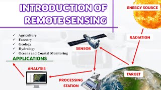
Satellite image processing is a fundamental component of Geo-Informatics that deals with the acquisition, enhancement, analysis, and interpretation of imagery obtained from remote sensing satellites. This chapter explores how raw satellite data is converted into valuable information for applications in urban planning, environmental monitoring, agriculture, disaster management, and infrastructure development. The accuracy and usefulness of satellite data depend heavily on systematic image processing techniques, making this chapter vital for understanding the scientific and practical foundations of Geo-Informatics.
Detailed Explanation
In this introduction, we understand that satellite image processing plays a crucial role in Geo-Informatics. It helps to take raw images obtained from satellites and convert them into usable data that can be used in various fields like urban planning and disaster management. The effectiveness of the satellite images relies on the methods and techniques used to process these images.
Examples & Analogies
Think of satellite images as a rough draft of a story. Just like an author needs to revise and edit their story to make it clear and meaningful, satellite image processing refines these raw images to make them informative and useful for decision-making in various areas like city planning or disaster response.
Types of Satellite Sensors
Chapter 2 of 9
🔒 Unlock Audio Chapter
Sign up and enroll to access the full audio experience
Chapter Content
3.1 Types of Satellite Sensors and Imagery
3.1.1 Passive and Active Sensors
• Passive Sensors: Rely on natural radiation (e.g., sunlight). Examples include optical and thermal infrared sensors.
• Active Sensors: Emit their own signals and measure the reflection. Examples include Synthetic Aperture Radar (SAR) and LiDAR.
Detailed Explanation
In this section, we classify satellite sensors into two main types: passive and active. Passive sensors capture images by relying on the sunlight that reflects off objects on the Earth's surface. In contrast, active sensors emit their own signals and then measure how these signals bounce back from the surfaces they hit.
Examples & Analogies
Imagine taking a photograph on a bright sunny day using a normal camera; that’s like using a passive sensor that depends on sunlight. Now, consider using a flashlight to see in the dark and taking a picture of what the light shows. That’s similar to how active sensors like LiDAR work—they shine their light and listen for the reflection.
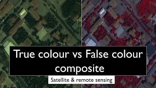
Multispectral vs. Hyperspectral Imagery
Chapter 3 of 9
🔒 Unlock Audio Chapter
Sign up and enroll to access the full audio experience
Chapter Content
3.1.2 Multispectral and Hyperspectral Imagery
• Multispectral Imagery: Captures data in 3 to 10 spectral bands. Example: Landsat.
• Hyperspectral Imagery: Captures data in hundreds of contiguous bands, enabling detailed material identification. Example: Hyperion.
Detailed Explanation
This section elaborates on two types of data captured by satellite sensors: multispectral and hyperspectral imagery. Multispectral imagery involves capturing images using several specific bands of light and is generally limited to a few bands. Hyperspectral imagery, on the other hand, captures hundreds of bands, allowing for much more detailed analysis of different materials and features on the earth's surface.
Examples & Analogies
Think of multispectral imagery as a box of crayons with a few colors. You can create some nice drawings with it, but there are limitations. Now, if you have a complete set of paints with countless shades (hyperspectral), you can create much more intricate and detailed artwork.
Panchromatic Imagery
Chapter 4 of 9
🔒 Unlock Audio Chapter
Sign up and enroll to access the full audio experience
Chapter Content
3.1.3 Panchromatic Imagery
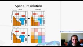
• High-resolution, single-band imagery in black and white, often used for enhancing spatial resolution through pan-sharpening.
Detailed Explanation
Panchromatic imagery refers to a type of satellite image that is captured in a single band, specifically in black and white. This type of image has high spatial resolution, meaning it can provide really detailed images of the Earth's surface. It's often integrated with multispectral images in a process called pan-sharpening to enhance the overall image quality and resolution.
Examples & Analogies
Consider taking a detailed black and white photo of a building. The image might capture intricate architectural details. Now, think of overlaying that black and white image with a colorful painting of the same building to achieve both detail and color richness in a final product—that’s pan-sharpening with panchromatic images.
Image Acquisition and Preprocessing
Chapter 5 of 9
🔒 Unlock Audio Chapter
Sign up and enroll to access the full audio experience
Chapter Content
3.2 Image Acquisition and Preprocessing
3.2.1 Radiometric Correction
• Correction of sensor irregularities and atmospheric interference.
• Converts raw Digital Numbers (DN) into calibrated reflectance values.
Detailed Explanation
Radiometric correction is a crucial step in the preprocessing of satellite images. It addresses imperfections that may occur during image capture, such as those caused by the sensor itself or atmospheric conditions. Correcting these issues allows us to convert the raw sensor data into usable reflectance values, which provides a more accurate representation of the Earth's surface.
Examples & Analogies
Imagine you take a photo through a foggy window. The fog distorts the colors and details. After cleaning the window (radiometric correction), the colors appear vibrant and clear, allowing you to see the true scene outside.
Geometric Correction
Chapter 6 of 9
🔒 Unlock Audio Chapter
Sign up and enroll to access the full audio experience
Chapter Content
3.2.2 Geometric Correction
• Aligns satellite images to real-world coordinates.
• Involves Ground Control Points (GCPs) and resampling techniques such as nearest neighbor, bilinear interpolation, and cubic convolution.
Detailed Explanation
Geometric correction is necessary to ensure that satellite images accurately correspond to their real-world locations. This process involves using Ground Control Points (GCPs) as references and adjusting the images so that they match a geographic coordinate system. Resampling techniques like nearest neighbor and bilinear interpolation help in refining these corrections.
Examples & Analogies
Think of using a paper map and trying to lay it on top of the actual landscape. If the map is wrinkled or out of alignment, it won’t match the real world. Geometric correction is akin to flattening and aligning that map so it perfectly overlays the terrain.
Atmospheric Correction
Chapter 7 of 9
🔒 Unlock Audio Chapter
Sign up and enroll to access the full audio experience
Chapter Content
3.2.3 Atmospheric Correction
• Eliminates effects of atmospheric scattering and absorption.
• Common methods: Dark Object Subtraction (DOS), Fast Line-of-sight Atmospheric Analysis of Spectral Hypercubes (FLAASH).
Detailed Explanation
Atmospheric correction is designed to remove the distortions caused by the Earth's atmosphere, such as scattering and absorption, which can alter the appearance of the images. Methods like Dark Object Subtraction (DOS) help in this process by accounting for the additional atmospheric effects and providing a clearer picture of the surface.
Examples & Analogies
Imagine you’re trying to view distant mountains, but the air is hazy due to pollution; the colors and details appear blurred. Atmospheric correction is like cleaning your glasses so you can see those mountains clearly again, revealing their true colors and details.
Noise Reduction
Chapter 8 of 9
🔒 Unlock Audio Chapter
Sign up and enroll to access the full audio experience
Chapter Content
3.2.4 Noise Reduction
• Filters used to remove random or systematic noise.
• Spatial filtering techniques like Median, Gaussian, and Low-pass filters are employed.
Detailed Explanation
Noise reduction involves applying various filters to satellite images to eliminate unwanted random disturbances or systematic artifacts that can distort the image quality. Techniques such as Median filters, Gaussian filters, and Low-pass filters are commonly used to achieve clearer results.
Examples & Analogies
Think of a noisy background when recording audio. Just as you would use a noise filter to remove distracting sounds, these filters help to clean up satellite images by smoothing out or removing noise, allowing for a sharper image.
Image Enhancement Techniques
Chapter 9 of 9
🔒 Unlock Audio Chapter
Sign up and enroll to access the full audio experience
Chapter Content
3.3 Image Enhancement Techniques
3.3.1 Contrast Stretching
• Linear or nonlinear methods used to enhance image contrast.
• Histogram equalization is a common technique.
Detailed Explanation
Image enhancement techniques focus on improving the visual quality of satellite images. Contrast stretching is one such technique that adjusts the image’s contrast, making some features more distinct. Histogram equalization further helps in redistributing the intensity values for a more balanced image display.
Examples & Analogies
It’s like adjusting the brightness and contrast settings on your TV to make colors pop. Just as a well-tuned screen shows more vivid details and nuances, contrast stretching enhances the visual appeal of satellite imagery.
Key Concepts
-
Passive Sensors: Sensors relying on natural light (e.g., optical sensors).
-
Active Sensors: Sensors that emit signals (e.g., LiDAR) for data collection.
-
Radiometric Correction: Adjusting data for sensor irregularities.
-
Geometric Correction: Aligning images to true geographic locations.
-
Image Classification: Categorizing pixel data into classes for analysis.
Examples & Applications
A passive sensor example is Landsat, which collects data using sunlight.
An active sensor example is RADAR, which sends out signals to measure surface reflections.
NDVI (Normalized Difference Vegetation Index) is a common application of band ratioing for assessing plant health.
Memory Aids
Interactive tools to help you remember key concepts
Rhymes
Landsat’s beams from the sun stay bright, capturing features in the daylight.
Stories
Imagine a painter using sunlight to create a beautiful landscape. The sun's rays are like passive sensors capturing nature's beauty, while a flashlight beam that reveals hidden secrets represents active sensors.
Memory Tools
Remember 'RAGE' for Image Processing: Radiometric correction, Atmospheric correction, Geometric correction, Enhancement techniques.
Acronyms
SAR for active sensors
Synthetic Aperture Radar.
Flash Cards
Glossary
- Passive Sensor
A type of sensor that relies on natural radiation, like sunlight, to gather data.
- Active Sensor
A sensor that emits its own signals to measure the reflection, such as Radar and LiDAR.
- Multispectral Imagery
Image data captured in 3 to 10 spectral bands.
- Hyperspectral Imagery
Image data captured in hundreds of contiguous spectral bands.
- Radiometric Correction
The adjustment of sensor data to correct for inconsistencies and atmospheric effects.
- Geometric Correction
The process of aligning satellite images to real-world geographic coordinates.
- Atmospheric Correction
Methods used to remove atmospheric effects on satellite imagery.
- Image Classification
The process of categorizing pixel data into different classes based on defined criteria.
- ObjectBased Image Analysis (OBIA)
A classification technique that segments images into meaningful objects rather than pixel-based classification.
Reference links
Supplementary resources to enhance your learning experience.