
Image Transformation and Fusion
Enroll to start learning
You’ve not yet enrolled in this course. Please enroll for free to listen to audio lessons, classroom podcasts and take practice test.
Interactive Audio Lesson
Listen to a student-teacher conversation explaining the topic in a relatable way.
Image Fusion Techniques
🔒 Unlock Audio Lesson
Sign up and enroll to listen to this audio lesson

Today, we will dive into the fascinating world of image fusion. Can anyone tell me what image fusion is?

Is it about combining images from different sensors?
Exactly! Image fusion combines data from multiple sensors, such as combining panchromatic and multispectral images to create high-resolution outputs. This is crucial for effective analysis. For instance, how do you think it helps in applications like urban planning?

It must provide clearer images for better decision making!
That's right! Methods like Intensity-Hue-Saturation (IHS), Principal Component Substitution (PCS), and Brovey Transform are commonly used. Can anyone remember what 'IHS' stands for?

Intensity-Hue-Saturation!
Great memory! Remember that these methods allow us to highlight important features effectively.
To summarize, image fusion enhances image quality by merging various data sources. Techniques like IHS and PCS are essential for this.
Vegetation and Water Indices
🔒 Unlock Audio Lesson
Sign up and enroll to listen to this audio lesson

Now, let's talk about vegetation and water indices. Who can tell me what NDVI stands for?
Normalized Difference Vegetation Index!
Very good! NDVI uses near-infrared and red bands to assess vegetation health. Why is that particularly useful in remote sensing?

It helps us know how healthy plants are, right?
Exactly! And what about NDWI? Anyone familiar with it?
It helps differentiate water bodies from land?
Spot on! Both indices are applied widely in environmental monitoring. So, to sum up, NDVI helps track vegetation health while NDWI identifies water bodies.
Tasseled Cap Transformation
🔒 Unlock Audio Lesson
Sign up and enroll to listen to this audio lesson
Next, let's discuss the Tasseled Cap Transformation. Who can explain what it achieves?
It transforms multispectral data into components like brightness, greenness, and wetness?
Exactly! This transformation simplifies analysis and helps in classifying land cover types. Why do you think these three components are important?
They focus on the main aspects needed for classification!
Great observation! The results of this transformation can lead to better land management strategies.
In summary, Tasseled Cap Transformation breaks down multispectral data into manageable components, facilitating effective classification and analysis.
Introduction & Overview
Read summaries of the section's main ideas at different levels of detail.
Quick Overview
Standard
In this section, we explore the methods of image fusion, which integrates data from different sensor types, and the usage of vegetation and water indices like NDVI and NDWI. We also cover the Tasseled Cap Transformation to derive essential components from multispectral data, which enhances the ability to classify and analyze land cover.
Detailed
Image Transformation and Fusion
This section emphasizes the significant techniques of image fusion and transformation utilized in enhancing satellite images for better analysis and interpretation.
Key Concepts:
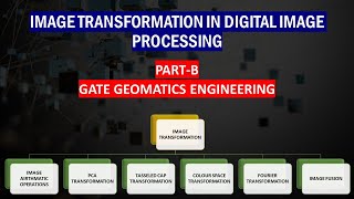
- Image Fusion: This process merges data from multiple sensors (for instance, combining panchromatic and multispectral imagery) to produce high-resolution images. This is essential for improved feature detection and classification. The prominent techniques used include:
- Intensity-Hue-Saturation (IHS)
- Principal Component Substitution (PCS)
- Brovey Transform
- Vegetation and Water Indices: These indices, notably the Normalized Difference Vegetation Index (NDVI) and Normalized Difference Water Index (NDWI), help differentiate various land covers. NDVI particularly uses near-infrared (NIR) and red bands to reveal vegetation health, while NDWI is crucial to discriminate water bodies from terrestrial surfaces.
- Tasseled Cap Transformation: This technique transforms multispectral data into components that yield three key features: brightness, greenness, and wetness, allowing for efficient land cover classification and analysis.
Through the application of these techniques, satellite image processing becomes a potent tool for urban planning, environmental monitoring, and other practical applications in Geo-Informatics.
Youtube Videos


Audio Book
Dive deep into the subject with an immersive audiobook experience.
Image Fusion
Chapter 1 of 3
🔒 Unlock Audio Chapter
Sign up and enroll to access the full audio experience
Chapter Content
• Combines data from multiple sensors (e.g., panchromatic + multispectral) to produce a high-resolution image.
• Techniques: Intensity-Hue-Saturation (IHS), Principal Component Substitution (PCS), Brovey Transform.
Detailed Explanation
Image fusion is a process that merges data from different sources to create an improved image. For instance, panchromatic images capture high-resolution details in grayscale, while multispectral images provide information in multiple colors or bands. By combining these types of images, we can achieve a final image that has both the detail of a panchromatic image and the color information of multispectral imagery. The fusion techniques mentioned, such as Intensity-Hue-Saturation (IHS), rearrange the image data in a way that the important features are preserved, enhancing the visual interpretation and analysis of the imagery.
Examples & Analogies
Think of image fusion as mixing different colors of paint to get a new shade. If you mix a bright yellow (panchromatic) with a rich blue (multispectral), you get a vibrant green that represents both colors. Just like in art, where the combination enhances the overall picture, combining different types of satellite images helps researchers and planners see land use and vegetation more clearly than either image alone.
Vegetation and Water Indices
Chapter 2 of 3
🔒 Unlock Audio Chapter
Sign up and enroll to access the full audio experience
Chapter Content
• NDVI (Normalized Difference Vegetation Index): Uses NIR and Red bands.
• NDWI (Normalized Difference Water Index): Differentiates water bodies from other land covers.
Detailed Explanation
Vegetation and water indices are mathematical formulas applied to satellite imagery, allowing for the analysis of specific features, like vegetation health and water presence. The NDVI is a popular index used to determine plant health by comparing the reflectance of near-infrared (NIR) light, which is strongly reflected by healthy vegetation, with red light, which is absorbed. A higher NDVI value indicates healthier greenery. Conversely, the NDWI uses similar principles but focuses on identifying water bodies by comparing NIR reflectance to short-wave infrared reflectance. This helps effectively distinguish water from land in satellite images.
Examples & Analogies
Imagine looking at a garden through different colored glasses. If you wear glasses that enhance the green color, you'll see which plants are healthy and thriving. That’s similar to how NDVI works. For NDWI, think of looking at a lake with special glasses that highlight the blue of the water, making it easier to spot the lake even among the surrounding land.
Tasseled Cap Transformation
Chapter 3 of 3
🔒 Unlock Audio Chapter
Sign up and enroll to access the full audio experience
Chapter Content
• Transforms multispectral data into new components like brightness, greenness, and wetness.
Detailed Explanation
The Tasseled Cap Transformation is a method used to convert complex multispectral data into simpler, interpretable components. It identifies three essential characteristics: brightness (overall light intensity of objects), greenness (amount of vegetation), and wetness (moisture content). These transformations simplify the analysis of satellite images, as they reduce the dimensionality of the data while emphasizing critical features relevant for ecological assessments, agricultural monitoring, and land cover classification.
Examples & Analogies
Consider a chef preparing a dish with different spices. Each spice adds a unique flavor, but when combined, they create a specific taste profile that's easier to appreciate. Similarly, Tasseled Cap Transformation takes the complex flavors of multispectral data and reduces them to key components that are much easier to analyze and understand, similar to how a chef simplifies many tastes into one alluring dish.
Key Concepts
-
Image Fusion: This process merges data from multiple sensors (for instance, combining panchromatic and multispectral imagery) to produce high-resolution images. This is essential for improved feature detection and classification. The prominent techniques used include:
-
Intensity-Hue-Saturation (IHS)
-
Principal Component Substitution (PCS)
-
Brovey Transform
-
Vegetation and Water Indices: These indices, notably the Normalized Difference Vegetation Index (NDVI) and Normalized Difference Water Index (NDWI), help differentiate various land covers. NDVI particularly uses near-infrared (NIR) and red bands to reveal vegetation health, while NDWI is crucial to discriminate water bodies from terrestrial surfaces.
-
Tasseled Cap Transformation: This technique transforms multispectral data into components that yield three key features: brightness, greenness, and wetness, allowing for efficient land cover classification and analysis.
-
Through the application of these techniques, satellite image processing becomes a potent tool for urban planning, environmental monitoring, and other practical applications in Geo-Informatics.
Examples & Applications
Using NDVI to monitor crop health during different growing seasons.
Applying NDWI to differentiate between lakes and land covers in satellite imagery.
Employing Tasseled Cap transformation to classify urban areas based on brightness and greenness.
Memory Aids
Interactive tools to help you remember key concepts
Rhymes
Fusion's fun, in layers we see, combining views, just like a tree.
Stories
Imagine a chef mixing different spices to make a flavorful dish; similarly, image fusion combines various data for an unbeatable view in remote sensing.
Memory Tools
FIND for memory: Fusion, Indices, NDVI, NDWI.
Acronyms
BAG - Brightness, Greenness, Wetness from Tasseled Cap Transformation.
Flash Cards
Glossary
- Image Fusion
The process of combining data from multiple sensors to create a single, high-resolution image.
- NDVI
Normalized Difference Vegetation Index, an index to assess vegetation health using NIR and Red bands.
- NDWI
Normalized Difference Water Index, used to differentiate between water bodies and other land covers.
- Tasseled Cap Transformation
A transformation technique that converts multispectral data into components of brightness, greenness, and wetness.
Reference links
Supplementary resources to enhance your learning experience.