
Applications of Total Station Surveys
Enroll to start learning
You’ve not yet enrolled in this course. Please enroll for free to listen to audio lessons, classroom podcasts and take practice test.
Interactive Audio Lesson
Listen to a student-teacher conversation explaining the topic in a relatable way.
Topographic Surveying
🔒 Unlock Audio Lesson
Sign up and enroll to listen to this audio lesson

Today we will explore how Total Stations are crucial in topographic surveying. Can anyone tell me what topographic maps illustrate?

They show the shapes of the land and elevation changes!
Exactly! Total Stations help create these maps accurately because they combine angle and distance measurements effectively. Who knows how these maps are structured?

They consist of contour lines, which show different heights.
Great! Can anyone recall why contour maps might be important in construction?

They help understand the terrain, which can affect building plans!
Exactly! Knowledge of the terrain is critical for ensuring structural stability and planning construction effectively. Let's summarize: Total Stations not only help in mapping the terrain but are essential for understanding how to work with it.
Construction Layout
🔒 Unlock Audio Lesson
Sign up and enroll to listen to this audio lesson

Now let's shift our focus to construction layout. How do you think Total Stations aid in correctly positioning pillars and buildings?

They provide exact measurements to ensure everything is in the right spot!
Correct! The precision of Total Stations minimizes errors during the layout phase. Can anyone think of a consequence of poor positioning?
It could lead to structural failures or costly reworks.
Exactly! Misplacement can indeed lead to significant financial losses and safety hazards. Remember this: accurate layout saves costs and enhances safety!
Monitoring Structures
🔒 Unlock Audio Lesson
Sign up and enroll to listen to this audio lesson
Let’s talk about how Total Stations can monitor existing structures. Why do you think structures need monitoring?
To check for any shifts or damage that might occur over time.
Exactly right! Continuous monitoring helps us detect early signs of deformation. What methods do you think are used to collect this data?
Repeated measurements using the Total Station?
Yes! Repeated accuracy over time can indicate changes in structural integrity. To summarize, monitoring with Total Stations is essential to ensure long-term safety.
Road and Railway Alignment
🔒 Unlock Audio Lesson
Sign up and enroll to listen to this audio lesson
Let’s explore transportation applications now, starting with road and railway alignment. What do you think is necessary when setting curves and gradients?
You need precise measurements to meet safety standards!
Perfect! The stored alignment data can be accessed with a Total Station to create safe and effective designs. Can someone explain how this contributes to overall safety?
If the curves and slopes aren't right, vehicles could have accidents.
Exactly! Proper alignment not only keeps vehicles safe but is critical for smooth traffic flow. Remember, Total Stations are central to transportation planning!
Introduction & Overview
Read summaries of the section's main ideas at different levels of detail.
Quick Overview
Standard
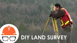
Total Station surveys have diverse applications in civil engineering, including topographic surveying for creating contour maps, construction layout for precise positioning, monitoring structural integrity over time, and alignment for transportation infrastructure. Additionally, they assist in volumetric calculations for land development projects.
Detailed
Applications of Total Station Surveys
Total Station surveys have a wide array of applications in civil engineering and geospatial analysis, significantly improving the accuracy and efficiency of various processes:
Topographic Surveying
- Creation of Contour Maps: Total Stations are used to produce detailed topographic maps containing contour lines that represent the elevations and depressions of the land surface.
- Digital Elevation Models (DEM): These models are generated to capture terrain information digitally, which is crucial for various analyses.
- Spot Height Plans: Precise spot measurements are made for significant topographic features.
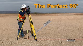
Construction Layout
- Marking Locations: Total Stations provide exact positioning for essential construction elements such as pillars, buildings, and overall infrastructure layout, ensuring accuracy in the initial stages of construction.
Monitoring Structures
- Repetitive Measurements: These surveys are paramount for tracking structural movement, including any displacement or subsidence, thereby ensuring safety and structural integrity.
- Detection of Deformations: Continuous monitoring helps identify any unforeseen warping or shifting of structures over time.
Road and Railway Alignment
- Setting Out Curves and Gradients: Using stored alignment data, Total Stations assist in establishing the appropriate curves, slopes, and gradients required in roadways and rail systems.
Volume Computation
- Cut-and-Fill Volumes: They are used to calculate the volumes of earth that need to be moved for excavation or land development, streamlining material management.
Total Station surveys significantly enhance the data collection process, ensuring a high degree of precision essential in modern civil engineering.
Youtube Videos


Audio Book
Dive deep into the subject with an immersive audiobook experience.
Topographic Surveying
Chapter 1 of 5
🔒 Unlock Audio Chapter
Sign up and enroll to access the full audio experience
Chapter Content
• Creation of contour maps, DEM, and spot height plans.
Detailed Explanation
Topographic surveying involves mapping the physical features of a landscape. This process creates contour maps, which show elevation changes across a terrain, Digital Elevation Models (DEM) that represent the Earth's surface, and spot height plans that display specific elevation points. These outputs help in understanding the terrain's shape and are vital for planning developments or conservation efforts.
Examples & Analogies
Imagine you are planning a hiking trail. You would want to know which areas are steep and which are flat. A topographic map created through surveying would show these details in contour lines, just like how a treasure map shows hills and valleys, helping hikers know what to expect along their journey.
Construction Layout
Chapter 2 of 5
🔒 Unlock Audio Chapter
Sign up and enroll to access the full audio experience
Chapter Content
• Marking exact locations for pillars, buildings, and infrastructure.
Detailed Explanation
In construction, Total Stations are used to precisely mark the locations where buildings, pillars, and infrastructure elements will be built. This ensures that buildings are constructed exactly where they are intended, without deviation. It helps in reducing errors and increasing efficiency during the construction process.
Examples & Analogies
Think of laying the foundation for a house. If the measurements are off by even a few centimeters, the entire structure can be unstable. Using a Total Station is like having a GPS for your construction site, ensuring every beam and wall is placed correctly, just like following the correct coordinates when navigating to a destination.
Monitoring Structures
Chapter 3 of 5
🔒 Unlock Audio Chapter
Sign up and enroll to access the full audio experience
Chapter Content
• Repeated measurements to detect displacement, subsidence, or deformation.
Detailed Explanation
Total Stations are also essential in monitoring existing structures over time. By taking repeated measurements, surveyors can detect any movement (displacement), sinking (subsidence), or deformities in structures such as bridges, buildings, and dams. This monitoring helps in maintaining safety and integrity of these structures.
Examples & Analogies
Imagine constantly checking the height of a tree you’ve planted. If it starts leaning to one side, you can catch it early and make adjustments. Similarly, monitoring a bridge over time allows engineers to identify early warning signs of potential issues, ensuring its safety and longevity.
Road and Railway Alignment
Chapter 4 of 5
🔒 Unlock Audio Chapter
Sign up and enroll to access the full audio experience
Chapter Content
• Setting out curves, gradients, and slopes using stored alignment data.
Detailed Explanation
In civil engineering, aligning roads and railways is crucial for safety and efficiency. Total Stations help by using stored data to establish curves, slopes, and gradients accurately. This ensures that the transportation routes are safe for vehicles and trains, improving overall travel experience.
Examples & Analogies
Think of a rollercoaster; it needs to be precisely designed for both thrill and safety. Total Stations ensure that roads and railways are laid out just as thoughtfully, providing smooth rides while avoiding dangerous curves or steep slopes that could lead to accidents.
Volume Computation
Chapter 5 of 5
🔒 Unlock Audio Chapter
Sign up and enroll to access the full audio experience
Chapter Content
• Measuring cut-and-fill volumes in excavation and land development.
Detailed Explanation
Volume computation is essential in excavation and development projects. Total Stations measure how much earth (soil, rock) needs to be removed (cut) or added (fill) to create a level surface for construction. This helps in estimating costs and planning logistics efficiently.
Examples & Analogies
Consider building a swimming pool in your yard — you’ll need to dig out a precise amount of dirt to create the perfect shape. Similarly, using Total Stations allows engineers to ensure they're removing or adding exactly the right amount of material for big projects, like roads or buildings, preventing excess expense and time.
Key Concepts
-
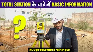
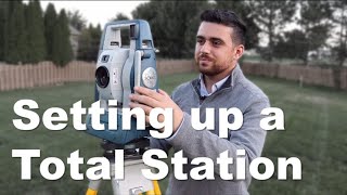
Total Station: An integrated measurement tool essential for modern surveying.
-
Topographic Surveying: Key for understanding land elevation and features.
-
Construction Layout: Vital for ensuring correct placement of structures.
-
Monitoring Structures: Helps assess safety and integrity over time.
-
Alignment in Infrastructure: Critical for safety and functionality of roads and railways.
-
Volume Computation: Essential for managing earthwork in construction.
Examples & Applications
Example 1: A civil engineer utilizes a Total Station to create a contour map for a new housing development, ensuring accurate representation of land elevation.
Example 2: During the construction of a bridge, a Total Station is employed to mark the exact locations of support pillars according to design specifications.
Memory Aids
Interactive tools to help you remember key concepts
Rhymes
Total Station on the site, measures both wrong and right, angles, distances, day and night.
Stories
Imagine a builder, John, who used a Total Station to ensure that his new house would be perfectly aligned on the land’s gentle slope, creating not only a sturdy foundation but also a charming view. With every detailed measurement, he made sure that the contour lines representing the hills and valleys were respected, keeping the house safe and sound.
Memory Tools
Remember the word 'T-C-M-V' to think of Total Station’s applications: Topographic surveying, Construction layout, Monitoring structures, and Volume computation.
Acronyms
Use 'TLC-VM' to recall key applications of Total Stations
Topography
Layout
Construction
Volume measurement
and Monitoring.
Flash Cards
Glossary
- Total Station
An electronic/optical instrument used in surveying that combines the functions of an electronic theodolite and an electronic distance meter.
- Topographic Surveying
The process of determining the elevation and geographical features of a specific area to create detailed maps.
- Contour Maps
Maps that use contour lines to represent elevation and terrain shape.
- Digital Elevation Model (DEM)
A digital representation of ground surface topography or terrain.
- Monitoring Structures
The practice of making repeated measurements on structures to assess any changes or movements over time.
- Alignment
The arrangement and positioning of features in a construction project, particularly regarding roads and railways.
- Volume Computation
The calculation of material volumes required for earthworks such as excavation or filling.
Reference links
Supplementary resources to enhance your learning experience.