
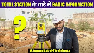
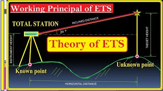
Working Principle of Total Station
Enroll to start learning
You’ve not yet enrolled in this course. Please enroll for free to listen to audio lessons, classroom podcasts and take practice test.
Interactive Audio Lesson
Listen to a student-teacher conversation explaining the topic in a relatable way.
Introduction to Total Station Functionality
🔒 Unlock Audio Lesson
Sign up and enroll to listen to this audio lesson

Today we will explore how a Total Station functions. Can someone tell me what a Total Station is?

Isn't it a device that helps in surveying?
Exactly! It combines an electronic theodolite with an Electronic Distance Measurement or EDM system. What do you think is the main purpose of these combined measurements?

To find the position of points, right?
Correct! The Total Station measures distances and angles to compute precise coordinates. Let's break this down into steps.

What does EDM specifically do?
The EDM uses a modulated beam, either infrared or laser, to measure the distance to a target. Can you remember this using the acronym 'DML' for Distance, Modulated, Laser?

That’s a good way to remember it!
Let's summarize: Total Stations measure slant distances and angles, which they use to calculate coordinates through trigonometric relationships. Good job today, everyone!
The Role of Angles and Trigonometric Relationships
🔒 Unlock Audio Lesson
Sign up and enroll to listen to this audio lesson

Now let's discuss how angles are measured and used in Total Stations. What types of angles do you think a Total Station measures?
Horizontal and vertical angles?
Exactly! The Total Station measures both. Once we have these angles, what can we do with them?
We can calculate the location of points using trigonometry!
Right! Let's look at the equations: X = D·cos(θ)·cos(α), Y = D·cos(θ)·sin(α), and Z = D·sin(θ). What do you think these variables represent?
D is the distance, θ is the vertical angle, and α is the horizontal angle.
That's correct! Remember the acronym 'DVH' for Distance, Vertical angle, Horizontal angle to make it easier. Now can anyone summarize how we calculate a coordinate using these angles?
We use the angles and distance together to find X, Y, Z.
Well done! So the more we use these equations, the clearer it becomes how Total Stations enhance surveying accuracy. Let’s conclude with that understanding.
Data Management in Total Stations
🔒 Unlock Audio Lesson
Sign up and enroll to listen to this audio lesson
Lastly, how do you think the data collected by the Total Station is saved and processed?
Is it stored internally or transferred somewhere?
Great question! The Total Station stores data internally in memory and also allows for external memory options. Why is data storage crucial in surveying?
So we can analyze the data later or use it for documentation!
Exactly! Moreover, this data can include point names, descriptions, and feature types. Who remembers the key terms we discussed earlier in the section?
Distance, angle, and coordinates!
Perfect! Remember those, as they are essential for understanding how Total Stations function in surveying. Excellent participation today, everyone!
Introduction & Overview
Read summaries of the section's main ideas at different levels of detail.
Quick Overview
Standard
The working principle of a Total Station integrates distance measurement through modulated beams and angle measurement using a theodolite, which collectively allow surveyors to calculate the coordinates of various points in a precise manner. This process is essential for modern surveying and geospatial data acquisition.
Detailed
Detailed Summary
Total Stations operate through a precise integration of distance and angle measurements that allow for the accurate determination of a point's coordinates. The process begins with the Electronic Distance Measurement (EDM), where a modulated infrared or laser beam is directed toward a target (like a prism), measuring the slant distance to it. Following this, the theodolite component of the Total Station measures the horizontal and vertical angles to the target. Utilizing trigonometric relationships, surveyors can compute the coordinates (X, Y, Z) of the target point:
- X = D·cos(θ)·cos(α)
- Y = D·cos(θ)·sin(α)
- Z = D·sin(θ)
Finally, the calculated data is stored in internal or external memory, ready for further processing. This seamless integration of measurements and data management exemplifies the technological advantage provided by Total Stations in the field of surveying and engineering.
Youtube Videos


Audio Book
Dive deep into the subject with an immersive audiobook experience.
Distance Measurement Using EDM
Chapter 1 of 4
🔒 Unlock Audio Chapter
Sign up and enroll to access the full audio experience
Chapter Content
- Distance Measurement using EDM via a modulated infrared or laser beam.
Detailed Explanation
Total Stations measure distance using an Electronic Distance Meter (EDM). The EDM emits a modulated infrared or laser beam towards a target (usually a reflector). When the beam hits the reflector, it bounces back to the Total Station. The device measures the time it takes for the beam to make this round trip. This time measurement allows the Total Station to calculate the distance accurately. This method is very precise, making it suitable for surveying where accuracy is essential.
Examples & Analogies
Imagine you are using a flashlight in a dark room. If you shine the flashlight at a wall and count how long it takes for the light to bounce back to you, you can estimate the distance to the wall based on the speed of light. Similarly, the EDM works by timing how long the laser light takes to return after hitting the reflector.
Angle Measurement Using Theodolite
Chapter 2 of 4
🔒 Unlock Audio Chapter
Sign up and enroll to access the full audio experience
Chapter Content
- Angle Measurement using the theodolite.
Detailed Explanation
In addition to measuring distances, a Total Station uses an integrated theodolite to capture angular measurements. The theodolite has a high degree of accuracy in measuring horizontal and vertical angles. It does this by aligning the telescope with the target and using precision instruments to determine the angles relative to a defined baseline. This is crucial for mapping and establishing coordinates in a survey.
Examples & Analogies
Think about how a compass works when you're navigating. It helps you determine the angle of direction you should take to reach your destination. Just like that, the theodolite helps surveyors find the exact angles needed to direct their measurements accurately.
Trigonometric Coordinate Calculation
Chapter 3 of 4
🔒 Unlock Audio Chapter
Sign up and enroll to access the full audio experience
Chapter Content
- Coordinate Calculation using the trigonometric relationships:
• X = D·cos(θ)·cos(α)
• Y = D·cos(θ)·sin(α)
• Z = D·sin(θ)
Detailed Explanation
After measuring the distance and angles, the Total Station calculates the coordinates of the point being surveyed using trigonometric relationships. The formulas shown capture how the distances (D) and angles (θ for vertical and α for horizontal angles) relate to the X, Y, and Z coordinates in a three-dimensional space. This helps transform the angles and the measured distance into a precise location in the coordinate system.
Examples & Analogies
Consider placing a point on a map. If you know how far away the point is and the angle to it, you can find its exact location by imagining a triangle where the distance is the hypotenuse. By using trigonometry, you can then determine how far left/right and up/down to go from your starting point to reach the target.
Data Storage for Processing
Chapter 4 of 4
🔒 Unlock Audio Chapter
Sign up and enroll to access the full audio experience
Chapter Content
- Data Storage into internal/external memory for further processing.
Detailed Explanation
Finally, after collecting measurements, the Total Station stores all the data in its internal memory, or if applicable, in external storage. This enables surveyors to process the data later on a computer. Working with digital data allows for greater flexibility and more complex calculations or adjustments as needed, significantly reducing the chances of manual errors.
Examples & Analogies
Think of a digital camera storing photos. Just like you can review, edit, and share your photos later, the Total Station’s storage allows surveyors to revisit the collected data, analyze it, and create precise maps or reports without having to redo the measurements.
Key Concepts
-
Total Station: An integrated instrument for surveying that combines distance and angle measurements.
-
Electronic Distance Measurement: Core component that measures distances to targets via infrared or laser.
-
Trigonometric Relationships: Mathematical formulas that link angles and distances to compute coordinates.
Examples & Applications
To find the position of a landmark, a surveyor uses a Total Station to measure the distance to the landmark and the angles from known points.
In engineering projects, Total Stations enable precise determination of building locations by calculating the coordinates of each point based on angles and distances.
Memory Aids
Interactive tools to help you remember key concepts
Rhymes
To find where to go, EDM and angles flow. With Total Stations in sight, coordinates are just right!
Stories
Imagine a surveyor standing on a hill, using a Total Station to measure distances to trees and buildings below. Each angle and distance tells a story about the land's layout!
Memory Tools
Remember 'DVA' for Distance, Vertical angle, and Angle for your measuring needs.
Acronyms
Use 'TAC' to remember
Total Station
Angle measurement
Coordinate calculation.
Flash Cards
Glossary
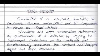
- Total Station
An electronic/optical instrument that integrates an electronic theodolite, an EDM, and a microprocessor to measure distances and angles for surveying.
- Electronic Distance Measurement (EDM)
A system that measures the slant distance from the Total Station to a target using modulated infrared or laser beams.
- Trigonometric Relationships
Mathematical relationships used to calculate the coordinates of points based on angles and distances.
- Coordinates
A set of values (X, Y, Z) that define the precise location of a point in three-dimensional space.
Reference links
Supplementary resources to enhance your learning experience.