
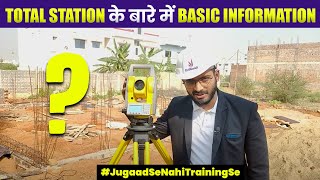
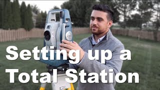
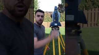
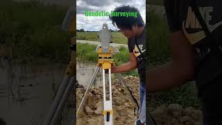
Setting Up and Operating a Total Station
Enroll to start learning
You’ve not yet enrolled in this course. Please enroll for free to listen to audio lessons, classroom podcasts and take practice test.
Interactive Audio Lesson
Listen to a student-teacher conversation explaining the topic in a relatable way.
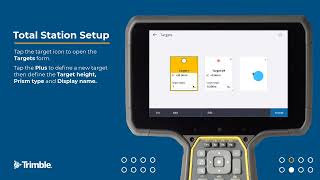
Instrument Setup
🔒 Unlock Audio Lesson
Sign up and enroll to listen to this audio lesson

Today, we will discuss the critical steps in setting up a Total Station. First, can anyone tell me why it's important to fix the tripod on firm ground?

Is it to prevent it from tipping over while we take measurements?
Exactly! A stable tripod ensures that the Total Station remains steady for accurate measurements. Now, what do we need to do after mounting the station on the tripod?

We need to center it over the survey point using a plummet, right?
Correct! Using the optical or laser plummet helps us locate the exact point for our survey. Leveling the instrument is also crucial. Can anyone tell me why?

If it's not level, the measurements can be incorrect, right?
Precisely! Always check both circular and electronic levels to ensure proper leveling. Great work! Let’s summarize this part: The steps to set up include fixing the tripod, mounting the Total Station, centering it, and leveling properly.
Initialization Process
🔒 Unlock Audio Lesson
Sign up and enroll to listen to this audio lesson

Now that we've set up our Total Station, the next step is initialization. What does initialization involve?
I think we power it on first?
That's correct! After powering on, we need to select or create a survey file. Can anyone explain why inputting known coordinates for the instrument is essential?
It helps the Total Station understand its position relative to the survey points.
Exactly! Proper initialization is key for accurate orientation. So, to summarize, initialization steps include powering on, selecting a survey job, and entering known coordinates.
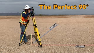
Orientation and Measurement Techniques
🔒 Unlock Audio Lesson
Sign up and enroll to listen to this audio lesson
We’ve completed the setup and initialization; now let’s discuss orientation and measurement. What's the first thing we do once the instrument is ready?
We measure the angle to the backsight point!
Correct! Measuring the angle to the backsight gives us a reference. After that, what’s our next step?

We turn to the target or prism to record measurements.
Exactly! You have the choice of using single-shot for one-time measurements or continuous tracking for more dynamic situations. Let’s recap: the process includes measuring the angle to the backsight, turning to the target, and choosing the right data acquisition mode.
Introduction & Overview
Read summaries of the section's main ideas at different levels of detail.
Quick Overview
Standard
In this section, we discuss the essential steps required for setting up and operating a Total Station effectively. These include fixing the tripod, leveling the instrument, initializing settings, and the methods for angle and distance measurement towards obtaining accurate survey data.
Detailed
Setting Up and Operating a Total Station
The process of setting up and operating a Total Station involves several critical steps to ensure accurate data collection. First, the instrument must be set up properly:
Instrument Setup
- Tripod Placement: The tripod should be fixed securely on firm ground, stable enough to hold the weight of the Total Station.
- Mounting the Total Station: The Total Station should be securely mounted on the tripod to ensure stability.
- Centering: Use the optical or laser plummet to center the instrument directly above the survey station point.
- Leveling: It is crucial to level the instrument using both circular and electronic levels for precise measurements.
Initialization
- Powering On: Turn on the Total Station to begin the setup process.
- Job Selection: Select an existing survey job or create a new file in the device.
- Input Coordinates: Enter known coordinates for the instrument and backsight to ensure accurate orientation.
Orientation and Measurement
- Backsight Measurement: Align and sight the backsight point, and measure the angle to establish a reference.
- Target Measurement: Turn the Total Station towards the target or prism from which measurements will be taken.
- Data Acquisition: Utilize either single shot or continuous tracking mode for efficient data collection.
Following this section is pivotal for aspiring surveyors, as it lays the groundwork for successful data acquisition in surveying projects.
Youtube Videos


Audio Book
Dive deep into the subject with an immersive audiobook experience.
Instrument Setup
Chapter 1 of 3
🔒 Unlock Audio Chapter
Sign up and enroll to access the full audio experience
Chapter Content
• Fix the tripod on firm ground.
• Mount the Total Station securely on the tripod.
• Use the optical or laser plummet to center over the survey station.
• Perform leveling using circular and electronic levels.
Detailed Explanation
Setting up a Total Station involves several careful steps. First, it’s important to place the tripod on stable, level ground to ensure a reliable foundation. Next, the Total Station is attached securely to the tripod to prevent it from tipping or moving during measurements. Then, using either an optical plummet or a laser plummet, you need to accurately center the instrument over the survey point, which is crucial for precision. Finally, leveling the device is essential, which can be done using its built-in circular and electronic levels to ensure that the instrument is perfectly horizontal. This ensures accurate angle and distance measurements throughout the survey.
Examples & Analogies
Think of setting up a Total Station like setting up a camera for a family photoshoot. Just like you would ensure your tripod is stable and the camera is level to capture the best shot, a surveyor must ensure that the Total Station is firmly positioned and leveled to take precise measurements.
Initialization
Chapter 2 of 3
🔒 Unlock Audio Chapter
Sign up and enroll to access the full audio experience
Chapter Content
• Power on the device.
• Select the survey job or create a new file.
• Input known instrument and backsight coordinates.
Detailed Explanation
Once the Total Station is set up, the next step is to initialize the instrument. You start by powering on the device. After it’s powered up, you’ll either select an existing survey job from memory or create a new file for your current work. It’s important to then input any known coordinates for the instrument position and the backsight point, which is the reference point that the Total Station will use for measurements. This initialization step is crucial as it lays the groundwork for all subsequent measurements.
Examples & Analogies
This step is similar to starting a new project on your computer. Just as you would power on your laptop, select a project, and enter necessary information before you start working, a surveyor does the same with the Total Station before taking measurements.
Orientation and Measurement
Chapter 3 of 3
🔒 Unlock Audio Chapter
Sign up and enroll to access the full audio experience
Chapter Content
• Sight the backsight point and measure the angle.
• Turn to the target/prism to record observations.
• Use single shot or continuous tracking mode for data acquisition.
Detailed Explanation
After the initialization, the surveyor must orient the Total Station. This involves sighting the backsight point, which helps establish a reference direction. Once the angle to the backsight is measured, the surveyor then aims at the target or prism to take measurements. During this process, two modes may be utilized: single shot, where a single measurement is taken at a time, or continuous tracking, where the Total Station continuously measures as the target moves. This flexibility allows for efficient data acquisition tailored to the surveyor's needs.
Examples & Analogies
Think of this process like using a telescope to observe celestial bodies. First, you would find a reference star (backsight) to align your view before looking at a planet. Similarly, the surveyor aligns the Total Station before measuring the intended target, ensuring accuracy in the data collected.
Key Concepts
-
Instrument Setup: The process of preparing the Total Station for operation by ensuring stability, centering, and leveling.
-
Initialization: Entering settings, including power on and inputting coordinates to prepare the Total Station for data collection.
-
Orientation and Measurement: The technique of targeting specific points and recording data through angle and distance measurements.
Examples & Applications
An example of instrument setup includes placing the Total Station over a control point and using the plummet for accuracy.
Once initialized, surveyors can measure angles to controls and begin collecting data for topographic mapping.
Memory Aids
Interactive tools to help you remember key concepts
Rhymes
To set up your Total Station with care, / Ensure the tripod’s positioned fair.
Stories
Imagine a surveyor on a calm, sunny day; they place a tripod on solid ground, making sure it's not swayed. They mount their Total Station with precision, ensuring they’ll gather data without any indecision.
Memory Tools
PLT - Place, Level, Target. Remember to place the Total Station, level it, and then target your measurements.
Acronyms
S.O.I
Setup
Orientation
Initialization. These steps help you remember the flow for using a Total Station.
Flash Cards
Glossary
- Total Station
An electronic/optical instrument used in surveying that combines the functions of theodolite, EDM, and data collector.
- Backsight Point
A reference point used for orientation in surveying, which must be sighted before taking subsequent measurements.
- Plummet
A device or laser used to center the instrument over the specified survey point.
- Angle Measurement
The process of determining the angle between two points, usually in horizontal or vertical dimensions.
- Data Acquisition
The act of collecting measurements, including angles and distances, during the surveying process.
Reference links
Supplementary resources to enhance your learning experience.