
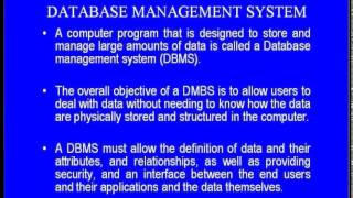
Data Storage and Database Management
Enroll to start learning
You’ve not yet enrolled in this course. Please enroll for free to listen to audio lessons, classroom podcasts and take practice test.
Interactive Audio Lesson
Listen to a student-teacher conversation explaining the topic in a relatable way.
Introduction to Spatial Databases
🔒 Unlock Audio Lesson
Sign up and enroll to listen to this audio lesson

Today, we're discussing spatial databases, which are crucial for managing geographic data. Can anyone tell me what a spatial database is?

Isn't it a type of database designed to handle spatial data like maps and coordinates?
Exactly! Spatial databases manage both spatial and attribute data, and they support complex queries necessary for analyzing geographic information. Can anyone name a few examples of spatial databases?

I've heard of PostgreSQL/PostGIS and Oracle Spatial!
Great! These databases help us store and manipulate geographic data effectively. Remember, the acronym 'P.O.S.' can help you recall PostgreSQL/PostGIS and Oracle Spatial. Are there any questions on this?
Data Formats in GIS
🔒 Unlock Audio Lesson
Sign up and enroll to listen to this audio lesson

Now, let’s dive into data formats. Who can list some common data formats for vector data?

Shapefiles and GeoJSON are popular for vector data.
Right! Shapefiles are widely used, but GeoJSON is becoming popular due to its ability to work seamlessly with web applications. Can anyone think of a raster data format?

TIFF is a common raster format because it supports high-resolution images.
Exactly! TIFF and JPEG2000 are both great for raster data. To remember these formats, think of 'S.G.' for Shapefiles and GeoJSON and 'T.J.' for TIFF and JPEG2000. Let’s move on to why these formats matter in GIS.
Data Compression and Indexing
🔒 Unlock Audio Lesson
Sign up and enroll to listen to this audio lesson
Lastly, let’s talk about data compression and indexing. Why do we use compression in GIS?
To save storage space and make data handling faster?
Exactly! Compression minimizes the amount of storage required while maintaining data quality. And what about indexing? How does it help us?
Indexing speeds up data retrieval, especially when dealing with large datasets.
Well said! Techniques like R-trees and quad-trees are used for spatial indexing. Remember: 'C.I.' means compression and indexing for efficiency in GIS databases. Any questions before we summarize what we've learned?
Introduction & Overview
Read summaries of the section's main ideas at different levels of detail.
Quick Overview
Standard
Covering key components of data storage, this section discusses spatial databases, various data formats, and techniques for efficient data management, including compression and indexing. Understanding these aspects is crucial for effective GIS applications in civil engineering.
Detailed
Data Storage and Database Management
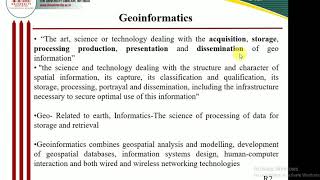
In this section, we explore the critical role of data storage and database management in Geographic Information Systems (GIS). GIS relies on spatial databases to manage both spatial and attribute data effectively. Notable spatial databases include PostgreSQL/PostGIS, Oracle Spatial, and ArcSDE, which provide the necessary framework for storing and querying complex spatial datasets.
Spatial Databases
Spatial databases are designed to handle geographic data, enabling efficient storage, retrieval, and manipulation of spatial information. They integrate various data types, including vector and raster, supporting complex queries and analyses crucial for applications such as urban planning and environmental monitoring.
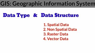
Data Formats
Data formats dictate how information is organized and stored in GIS. Common vector formats include:
- Shapefiles (.shp): Widely used for storing vector data.
- GeoJSON: A modern format for encoding a variety of geographic data structures.
- KML: Keyhole Markup Language, used for representing geographic data in XML format.
For raster data, formats such as TIFF, IMG, GRID, and JPEG2000 are commonly employed, allowing for detailed imagery and geographic representation.
Data Compression and Indexing
Efficient data storage is vital to optimizing performance, especially with large datasets. Techniques like data compression minimize storage needs without sacrificing quality. Spatial indexing methods, such as R-trees and quad-trees, enhance data retrieval speed, making analysis more efficient and effective.
In conclusion, understanding data storage and database management within GIS is essential for leveraging geographic data in various civil engineering applications. Attention to database design, format selection, and indexing plays a pivotal role in the efficiency of GIS operations.
Youtube Videos


Audio Book
Dive deep into the subject with an immersive audiobook experience.
Spatial Databases
Chapter 1 of 3
🔒 Unlock Audio Chapter
Sign up and enroll to access the full audio experience
Chapter Content
A spatial database manages both spatial and attribute data.
Common databases include PostgreSQL/PostGIS, Oracle Spatial, and ArcSDE.
Detailed Explanation
Spatial databases are structured to handle both types of data commonly used in geographical information systems: spatial data (which involves location and geometric shapes) and attribute data (which provides additional information about spatial features). Examples of spatial databases include PostgreSQL/PostGIS, Oracle Spatial, and ArcSDE, which are popular for GIS applications because they allow users to efficiently store, query, and manipulate geographical data in relation to its attributes. Understanding how these databases work is critical for managing complex datasets effectively, enabling users to retrieve and analyze the information as needed.
Examples & Analogies
Think of a spatial database like a library. Just as a library has shelves for different books (spatial data) and each book has information like the author and publication date (attribute data), a spatial database organizes geographic information so it can be easily found and understood.
Data Formats
Chapter 2 of 3
🔒 Unlock Audio Chapter
Sign up and enroll to access the full audio experience
Chapter Content
• Vector: Shapefiles (.shp), GeoJSON, KML.
• Raster: TIFF, IMG, GRID, JPEG2000.
Detailed Explanation
Data formats are essential for storing and sharing geographic data. There are primarily two types of data formats in GIS: vector and raster. Vector formats, such as Shapefiles, GeoJSON, and KML, are used to represent discrete features with precise boundaries (like roads and rivers). Raster formats, such as TIFF, IMG, GRID, and JPEG2000, are used for continuous data such as images and classifications (like satellite imagery showing vegetation cover). Knowing these formats is crucial for anyone working with GIS, as it influences how data can be used and integrated into various applications.
Examples & Analogies
Imagine using different types of containers to store items. Vector formats are like boxes that maintain the shape of the contents (like a model of a house), while raster formats are more like bags filled with a collection of items (like a photo that captures everything in a scene). Each container has its purpose, making it necessary to choose the right type for the job at hand.
Data Compression and Indexing
Chapter 3 of 3
🔒 Unlock Audio Chapter
Sign up and enroll to access the full audio experience
Chapter Content
• Efficient data storage involves compression techniques.
• Spatial indexing (e.g., R-trees, quad-trees) improves data retrieval.
Detailed Explanation
Data compression techniques reduce the size of data files, making them easier to store and faster to transfer, which is vital for databases that handle large volumes of geographic data. Alongside compression, spatial indexing techniques, such as R-trees and quad-trees, help organize data in a way that speeds up the retrieval process, allowing GIS applications to quickly find and access the information needed for various analyses. This is particularly important in real-time GIS applications where speed and efficiency are paramount.
Examples & Analogies
Consider packing for a trip. By compressing your clothes (rolling them tightly or using vacuum bags), you save space in your suitcase, allowing you to carry more. Spatial indexing works similarly; it's like creating a map of your suitcase, so you can easily find your favorite shirt without digging through everything.
Key Concepts
-
Spatial Databases: Used to manage both spatial and attribute data.
-
Data Formats: Various formats for vector (Shapefiles, GeoJSON) and raster (TIFF, JPEG2000) data.
-
Data Compression: Techniques to reduce storage space while maintaining data quality.
-
Indexing: Methods that enhance data retrieval speed, vital for efficient GIS operations.
Examples & Applications
PostgreSQL/PostGIS is often used in urban planning to analyze geographic data for city development.
GeoJSON is commonly used in web mapping applications due to its lightweight structure.
Memory Aids
Interactive tools to help you remember key concepts
Rhymes
Spatial databases hold the map, with attributes up for a tap.
Stories
Imagine a librarian who organizes books not just by title, but also by topic and author—much like a spatial database organizes geographic data.
Memory Tools
Remember 'V.R.' for Vector and Raster—two essential data format types in GIS.
Acronyms
'C.I.' stands for Compression and Indexing, two key concepts for efficient data handling.
Flash Cards
Glossary
- Spatial Database
A database optimized for storing and querying spatial data, including both spatial and attribute data.
- Vector Format
Data representation that uses points, lines, and polygons to define spatial features.
- Raster Format
Data format representing spatial information as a grid of pixels, typically used for images or continuous data.
- Compression
The process of reducing the size of data files to save storage space.
- Indexing
A method to optimize the speed of data retrieval operations on a database.
Reference links
Supplementary resources to enhance your learning experience.