
Citizen-Centric Planning and Participatory GIS
Enroll to start learning
You’ve not yet enrolled in this course. Please enroll for free to listen to audio lessons, classroom podcasts and take practice test.
Interactive Audio Lesson
Listen to a student-teacher conversation explaining the topic in a relatable way.
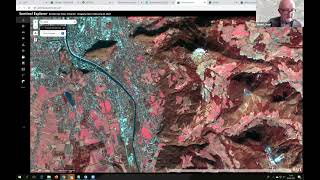
Crowd-Sourced Geo-Informatics
🔒 Unlock Audio Lesson
Sign up and enroll to listen to this audio lesson

Today we'll discuss crowd-sourced geo-informatics. How do you think mobile apps can help cities?

They could let people report issues like potholes or broken streetlights!
Exactly! These apps are vital for real-time data collection. Can anyone give me an example of a common urban issue that might be reported?

Waterlogging during heavy rains?
Great example! This feedback directly informs city planners. Now, does anyone know how this data is utilized?

I think it helps in prioritizing repairs and maintenance.
Exactly! When citizens actively participate, it not only leads to quicker decisions but also fosters community trust. Remember the acronym 'ACT'—Awareness, Collaboration, Trust.

So, the more we engage, the better the planning becomes?
Precisely! Let's summarize: crowd-sourced geo-informatics improves reporting and fosters community engagement.
Participatory Urban Design
🔒 Unlock Audio Lesson
Sign up and enroll to listen to this audio lesson

Now, let’s move on to participatory urban design. How do we gather citizen feedback effectively?
Using geo-tagged feedback to locate areas of concern.
Exactly! Heatmaps of public opinion can visualize community sentiments. Why is this important?
It helps ensure that urban changes reflect the actual needs of the community.
Correct! It also builds trust between citizens and planners. Can anyone think of a disadvantage of this feedback system?
What if some people don't have access to smartphones to give feedback?
That’s a valid concern and highlights the importance of inclusivity in planning. Let's remember: 'Feedback Loop' is crucial for effective participatory urban design.
So it all connects back to improving communication and collaboration?
Absolutely! To summarize, participatory design empowers citizens through geo-tagged feedback and creates a collaborative atmosphere in urban planning.
Introduction & Overview
Read summaries of the section's main ideas at different levels of detail.
Quick Overview
Standard
Citizen-centric planning leverages technology through mobile applications to gather data from citizens about urban issues. Participatory GIS (Geographic Information Systems) not only allows for geo-tagged feedback, but also fosters community trust and collaboration in urban design initiatives.
Detailed
Citizen-Centric Planning and Participatory GIS
Citizen-centric planning emphasizes the importance of involving the public in urban planning processes. By utilizing crowd-sourced geo-informatics, citizens can contribute valuable data through mobile apps designed for reporting urban issues like potholes, broken infrastructure, and waterlogging. These platforms enable real-time engagement between communities and planners, reflecting citizen concerns directly in decision-making processes.
Participatory GIS enhances urban design by incorporating geo-tagged feedback from residents into zoning plans. Heatmaps generated from public opinions and complaints not only visualize the needs of the community but also facilitate better trust and collaboration between citizens and planners. This section underscores the critical role of technology in making urban development more inclusive and responsive to the actual needs of the population.
Youtube Videos


Audio Book
Dive deep into the subject with an immersive audiobook experience.
Crowd-Sourced Geo-Informatics
Chapter 1 of 2
🔒 Unlock Audio Chapter
Sign up and enroll to access the full audio experience
Chapter Content
- Use of mobile apps to collect data from citizens
- Reporting potholes, broken infrastructure, or waterlogging via GIS-enabled apps
Detailed Explanation
Crowd-sourced geo-informatics refers to the method of gathering geographic data through mobile applications used by citizens. These apps allow individuals to report issues in their local area, such as potholes, damaged infrastructure, or instances of waterlogging. This information becomes valuable for urban planners and local governments as it reflects real-time issues faced by the community.
Examples & Analogies
Imagine you have a group of friends who notice various problems in their neighborhood, like potholes and broken streetlights. Instead of simply talking about these issues, they utilize an app that enables them to report these problems directly to the city’s administrative office. Just like how this group can collectively raise awareness about the issues, crowd-sourced geo-informatics allows numerous citizens to contribute information, leading to more effective and timely city planning and infrastructure maintenance.
Participatory Urban Design
Chapter 2 of 2
🔒 Unlock Audio Chapter
Sign up and enroll to access the full audio experience
Chapter Content
- Geo-tagged citizen feedback for zoning plans
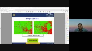
- Heatmaps of public opinion or complaints
- Improved trust and collaboration with the community
Detailed Explanation
Participatory urban design involves engaging citizens in the decision-making processes regarding urban development and planning. This approach uses tools like geo-tagged feedback, which allows residents to mark specific locations on maps where they have concerns or suggestions. Heatmaps generated from this feedback can visually represent areas of high public concern or complaint. This process not only helps gather valuable input for zoning plans but also fosters a sense of trust and collaboration between community members and urban planners.
Examples & Analogies
Think of it like a community garden project. Residents in a neighborhood are invited to share their ideas about what they would like to see in the garden – flowers, vegetables, benches for sitting – and they place stickers on a large map of the garden to show their preferences. The resulting layout takes everyone’s input into account, which can lead to a healthy, diverse garden that reflects what the community really wants. Similarly, participatory urban design incorporates the voices of citizens in planning urban spaces to create environments that meet public needs and desires.
Key Concepts
-
Crowd-sourced geo-informatics: Technology allowing citizens to provide real-time data about urban issues.
-
Participatory urban design: Involving citizens through geo-tagged feedback to influence zoning and planning.
-
Heatmaps: Visual tools representing data to show areas of concern based on public input.
Examples & Applications
A mobile app that allows citizens to report waterlogging directly to the city council for quicker resolution.
Using heatmaps to visualize public opinion on proposed zoning regulations, showing areas with high complaint density.
Memory Aids
Interactive tools to help you remember key concepts
Rhymes
In the city, hear the call, citizen feedback helps us all.
Stories
Imagine a town where every citizen reports issues through an app, creating a happy community and efficient planning.
Memory Tools
C-I-T-I-Z-E-N: Collecting Input Through Involvement, Zealous Engaged Neighbors.
Acronyms
G.E.O
Gather Engage Optimize for better urban development.
Flash Cards
Glossary
- CitizenCentric Planning
An approach to urban planning that focuses on engaging and involving citizens in the decision-making process.
- CrowdSourced GeoInformatics
The use of technology, particularly mobile applications, to collect geographical data from the public.
- Participatory GIS
A geographic information system that allows citizens to contribute data and feedback into the planning processes.
- Geotagged Feedback
User-contributed information that includes geographic coordinates, helping to locate issues in urban areas.
- Heatmaps
Visual representations of data where individual values are represented as colors; often used to indicate the density of feedback or opinions.
Reference links
Supplementary resources to enhance your learning experience.