
Climate Resilient Infrastructure Planning
Enroll to start learning
You’ve not yet enrolled in this course. Please enroll for free to listen to audio lessons, classroom podcasts and take practice test.
Interactive Audio Lesson
Listen to a student-teacher conversation explaining the topic in a relatable way.
The need for Climate-Adaptive Design
🔒 Unlock Audio Lesson
Sign up and enroll to listen to this audio lesson

As we experience more and more extreme weather events, why do you think civil infrastructure must be designed with climate resilience in mind?

Because extreme weather can damage infrastructure and endanger lives!
Exactly! We need to ensure our infrastructure can withstand events like floods and heatwaves. This brings us to the concept of climate-adaptive design. Can anyone share what you think climate-adaptive design includes?

Maybe using materials that are more resistant to impacts from weather?
That's one aspect. It also includes planning and incorporating design principles that take future climate conditions into account. Think of the acronym RESILIENT! Can anyone guess what it could stand for?

Regularly Evaluating Sustainability in Infrastructure through Long-term Environmental Needs and Trends?
Great effort! It's not the complete one, but it captures the idea of resilience. The key is to adapt our designs to not just current but also future climates. What impacts can the lack of climate resilience have?

Buildings could fail during storms, and communities could be at a higher risk of disaster.
That's right! In this session, we’ve highlighted the importance of climate-adaptive design. To recap, implementing resilient structures is crucial as it provides safety and sustainability.
GIS Role in Climate Adaptation
🔒 Unlock Audio Lesson
Sign up and enroll to listen to this audio lesson

Now, let's delve deeper into the role of GIS in climate adaptation. How do you think GIS can help us design climate-resilient infrastructure?
It can help visualize the impacts of climate challenges on different infrastructures, right?
Absolutely! GIS allows us to create detailed models. For instance, can anyone explain how flood risk modeling under future climate scenarios works?
It would use historical data and project it onto future scenarios?
Exactly! With GIS, we can layer data to understand potential flooding areas in the future. Another application is mapping urban heat islands. Why do you think that’s significant?
Because it helps identify hotspots in cities which need more ventilation?
Yes, and by knowing these areas, we can plan interventions to improve urban livability. Sea level rise simulations also help in evaluating potential risks to coastal areas. This knowledge is crucial for planning ahead. Can anyone summarize the applications of GIS we discussed?
We talked about flood modeling, heat mapping, and sea level rise simulations, showing how GIS can help us adapt to climate change.
Precisely! To conclude this session, GIS is essential in planning climate-resilient infrastructure, helping us visualize changes and impacts that inform better engineering decisions.
Green Infrastructure and Resilience Measures
🔒 Unlock Audio Lesson
Sign up and enroll to listen to this audio lesson
Finally, let's talk about green infrastructure. What do you think that means in the context of climate resilience?
It involves using natural processes to manage water and improve environmental quality?
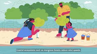
Exactly! Green infrastructure, like bio-swales or permeable pavements, enhances the environment's ability to absorb rainwater and manage floods. How might using these in urban environments benefit us?
They can reduce flooding and provide green spaces for recreation!
Right! Also, they help maintain healthier ecosystems. Can anyone recall another benefit of green infrastructure beyond flooding?
Maybe they help with air quality by reducing pollutants?
Correct! To wrap up, integrating green infrastructure into our designs not only enhances resilience but also promotes environmental health. Let’s summarize what we learned about green infrastructure today.
We discussed how green infrastructure aids in flood management, improves urban aesthetics, and enhances air quality. It's beneficial for cities overall.
Fantastic summary! Green infrastructure is key to developing sustainable cities that can adapt to climate impacts.
Introduction & Overview
Read summaries of the section's main ideas at different levels of detail.
Quick Overview
Standard
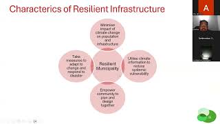
The need for climate-resilient infrastructure is underscored by the increasing frequency of extreme weather events. GIS plays a pivotal role in this context, facilitating flood risk modeling, urban heat island mapping, and simulating sea level rise impacts on coastal infrastructure.
Detailed
Climate Resilient Infrastructure Planning
Climate resilience in infrastructure planning is essential due to the rising frequency of extreme weather events driven by climate change. Civil infrastructure must be designed to adapt to these challenges to ensure long-term sustainability and functionality.
GIS (Geographic Information Systems) is an invaluable tool in this planning phase. It enables civil engineers to conduct specialized analyses, such as:
- Flood Risk Modeling: Using future climate scenarios to predict potential flooding risks and develop mitigation strategies.
- Urban Heat Island Mapping: Identifying areas within urban environments that are more susceptible to heat accumulation for efficient ventilation planning.
- Sea Level Rise Simulations: Evaluating potential impacts on coastal infrastructure, allowing for strategic planning and adaptation.
- Green Infrastructure Placement: Designing and integrating features like bio-swales and permeable pavements to enhance environmental resilience.
In summary, this section highlights the critical integration of climate-adaptive design in civil engineering, facilitated by GIS, to promote sustainable and resilient infrastructure in the face of climate challenges.
Youtube Videos


Audio Book
Dive deep into the subject with an immersive audiobook experience.
Need for Climate-Adaptive Design
Chapter 1 of 2
🔒 Unlock Audio Chapter
Sign up and enroll to access the full audio experience
Chapter Content
With increasing frequency of extreme weather events, civil infrastructure must be designed with climate resilience in mind.
Detailed Explanation
This chunk discusses the necessity for designing civil infrastructure that can withstand the impacts of climate change. As extreme weather events, such as heavy storms, flooding, and heatwaves, become more common, infrastructure needs to be resilient. This means that engineers and planners must anticipate these events and ensure that structures like roads, bridges, and buildings can endure or recover from them, thereby protecting lives and investments.
Examples & Analogies
Think of a home built in a flood-prone area. If the house is elevated or built with flood-resistant materials, it can withstand heavy rainfall better than a conventional home. Similarly, cities need to build roads and bridges that can handle increased rainfall and rising sea levels.
GIS Role in Climate Adaptation
Chapter 2 of 2
🔒 Unlock Audio Chapter
Sign up and enroll to access the full audio experience
Chapter Content
• Flood risk modelling under future climate scenarios
• Mapping urban heat islands for ventilation planning
• Sea level rise impact simulations for coastal infrastructure
• Green infrastructure placement (bio-swales, permeable pavements)
Detailed Explanation
This chunk highlights various ways Geographic Information Systems (GIS) can contribute to climate adaptation strategies. By using GIS tools, engineers can model the risk of flooding by predicting how future climate scenarios may change precipitation patterns. They can also analyze urban heat islands—areas that become significantly warmer than their rural surroundings, enabling better planning for ventilation and cooling. Additionally, GIS helps simulate the potential impacts of rising sea levels on coastal areas, which is critical for infrastructure planning. Lastly, it aids in the placement of green infrastructure, such as bio-swales and permeable pavements, which help manage stormwater and reduce heat absorption in urban environments.
Examples & Analogies
Imagine a city using GIS to identify 'hot spots' that suffer from high temperatures by comparing them with cooler areas nearby. By planting more trees and installing green roofs in the identified heat islands, the city can cool these areas effectively. Similarly, using GIS, planners can visualize how rising sea levels might affect neighborhoods near the coast and plan for effective preventive measures.
Key Concepts
-
Climate Resilience: The ability of infrastructure to withstand and recover from climate-related events.
-
Flood Risk Modeling: Predictive analysis of flood scenarios for effective planning.
-
Urban Heat Islands: Urban regions with higher temperatures due to human factors.
-
Green Infrastructure: Integrating natural elements in urban design to improve resilience.
-
GIS: A technological tool used for spatial data analysis and visualization to aid planning.
Examples & Applications
Employing GIS to simulate the impact of future flooding events on urban infrastructure.
Using green roofs and bio-swales in city design to manage stormwater efficiently.
Memory Aids
Interactive tools to help you remember key concepts
Rhymes
To keep our cities green and bright, green roofs help keep the floods in sight.
Stories
Once in a town where floods were rife, an engineer dreamed of a green-life. With GIS by their side, they planned with pride, a future where safety and green would thrive.
Memory Tools
Remember the word 'A-WE-GFR' for resilience: Adaptation, Water management, Economic planning, Green infrastructure, Flood modeling, Recovery strategies.
Acronyms
GIS
Geographic Intelligent Solutions; a tool to assist in planning for climate adaptation.
Flash Cards
Glossary
- Climate Resilience
The ability of infrastructure to withstand and recover from climate-related events and damage.
- Flood Risk Modeling
The process of predicting potential flood risks based on varying climate scenarios and historical data.
- Urban Heat Island
An urban area that experiences significantly warmer temperatures than its rural surroundings due to human activities.
- Green Infrastructure
An approach that integrates natural processes and elements into urban design to manage stormwater and improve environmental quality.
- GIS (Geographic Information Systems)
Technology for mapping and analyzing spatial and geographic data to inform planning decisions.
Reference links
Supplementary resources to enhance your learning experience.