
Heritage and Archaeological Site Protection
Enroll to start learning
You’ve not yet enrolled in this course. Please enroll for free to listen to audio lessons, classroom podcasts and take practice test.
Interactive Audio Lesson
Listen to a student-teacher conversation explaining the topic in a relatable way.
Mapping Heritage Zones
🔒 Unlock Audio Lesson
Sign up and enroll to listen to this audio lesson

Today, we’ll discuss how geo-informatics plays a crucial role in heritage and archaeological site protection, starting with the mapping of heritage zones. Why do you think it's essential to delineate protected zones around monuments?

To make sure we can control what happens around those sites and prevent damage, right?
Exactly! Delineating these zones helps create a legal framework for protection. And how might we monitor encroachments that threaten these areas?

Maybe by using satellite images to spot any changes over time?
Absolutely! Temporal satellite imagery is vital for monitoring encroachment. This way, authorities can intervene quickly if needed. Remember the acronym MAP: Monitor, Assess, and Protect. Any questions about this approach?

How do we use this technology to plan for utilities near heritage sites?
Great question! By understanding where heritage zones are located, we can plan underground utilities to minimize disruption. It’s all about sustainable planning. Let's summarize: We use geo-informatics to delineate protected zones, monitor encroachments, and plan underground utilities. Any thoughts?

It sounds like a smart way to balance development with preserving our history.
Documentation and 3D Modelling
🔒 Unlock Audio Lesson
Sign up and enroll to listen to this audio lesson

Now, let’s discuss documentation techniques like photogrammetry and LiDAR. What do you think are the benefits of creating 3D replicas of heritage sites?
They must help keep track of the site’s condition and guide restorations.
Exactly! These accurate models serve as pillars for restoration planning. They help ensure that any restoration respects the original materials and architecture. What else can such models do?
They could make the sites more appealing for tourists, right?
Yes! By using these technologies, we can create immersive experiences for tourists, which enhances their understanding of the site's historical value. Remember the acronym TRIP: Technology, Respect, Immerse, Promote. Any thoughts on how this impacts tourism?
I guess it brings more attention and preservation awareness!
Exactly! So, to summarize, we use photogrammetry and LiDAR for accurate documentation, guide restoration efforts, and promote tourism through immersive experiences. Any final questions?
Just how much can we rely on this technology for future preservation?
Introduction & Overview
Read summaries of the section's main ideas at different levels of detail.
Quick Overview
Standard
Geo-informatics plays a crucial role in preserving heritage and archaeological sites by facilitating the mapping of protected areas, monitoring encroachments, and supporting documentation and restoration efforts through advanced modeling techniques.
Detailed
Heritage and Archaeological Site Protection
Overview
This section focuses on the significance of geo-informatics tools in the protection of heritage and archaeological sites. As commercial and urban developments intensify, the risk of encroachment and damage to these critical areas increases, necessitating effective monitoring and management strategies.
Mapping Heritage Zones
- Delineation of Protected Zones: Geo-informatics allows for the clear delineation of protected zones around significant monuments. These mapped zones help in legal and administrative frameworks to ensure that such areas are respected and preserved.
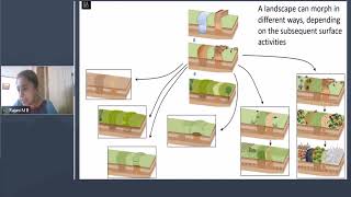
- Monitoring Encroachment: Temporal satellite imagery provides crucial data for monitoring any encroachments that might threaten the integrity of heritage sites. This real-time data enables timely interventions to protect these areas.
- Planning of Underground Utilities: Understanding the location and boundaries of heritage zones is essential for planning any underground utility works nearby, minimizing disruption to the sites.
Documentation and 3D Modelling
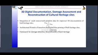
- Photogrammetry and LiDAR: Advanced tools such as photogrammetry and LiDAR are employed to produce accurate 3D replicas of heritage sites. This accurate documentation aids in both restoration planning and promoting tourism.
- Beneficial for Restoration Planning: Accurate models can serve as a reference during restoration efforts, ensuring that any interventions respect the original architecture and materials.
- Support for Tourism Development: These technologies also enhance the visitor experience by creating immersive experiences that engage tourists and educate them about the site's historical significance.
Importance
The preservation of cultural heritage through geo-informatics not only safeguards our history but also informs sustainable development practices that balance urban growth with cultural integrity.
Youtube Videos


Audio Book
Dive deep into the subject with an immersive audiobook experience.
Mapping Heritage Zones
Chapter 1 of 2
🔒 Unlock Audio Chapter
Sign up and enroll to access the full audio experience
Chapter Content
Geo-Informatics tools are used to:
- Delineate protected zones around monuments
- Monitor encroachment via temporal satellite imagery
- Plan underground utility works near heritage zones
Detailed Explanation
This chunk focuses on the use of Geo-Informatics tools to protect heritage zones. Firstly, these tools help identify and outline what areas need protection, especially around important cultural monuments. This is crucial because it prevents accidental damage during construction or urban expansion. Secondly, monitoring encroachment involves using satellite images taken over time to see if any new structures or activities are infringing on these protected zones. Lastly, planning for utility work, such as laying down water pipes or electricity lines, must consider these heritage areas to avoid causing damage.
Examples & Analogies
Imagine you have a favorite park with historical statues. Just like park rangers would have specific boundaries marked to protect the park, civil engineers use Geo-Informatics to draw similar boundaries around monuments. When someone tries to build a new shopping mall nearby, the park rangers can quickly check satellite images to see if any part of the mall would infringe on the protected area, ensuring the park's integrity remains intact.
Documentation and 3D Modeling
Chapter 2 of 2
🔒 Unlock Audio Chapter
Sign up and enroll to access the full audio experience
Chapter Content
• Photogrammetry and LiDAR used for creating accurate 3D replicas
• Useful for restoration planning and tourism development
Detailed Explanation
This chunk discusses the technologies used for documenting heritage sites, primarily focusing on photogrammetry and LiDAR. Photogrammetry involves taking numerous photographs of a monument from different angles and using these images to create a detailed 3D model. On the other hand, LiDAR (Light Detection and Ranging) uses laser beams to gather high-precision spatial data, enabling the creation of even more detailed 3D representations. These 3D models serve two main purposes – they aid in restoration efforts by providing a reference for repairs and refurbishments, and they enhance tourism by allowing virtual tours and interactive experiences of these historical sites.
Examples & Analogies
Think of a 3D movie. Just as 3D technology brings a movie to life for viewers, photogrammetry and LiDAR create lifelike models of historical monuments. If a statue is damaged, workers can use the 3D model as a guide to restore it accurately. Additionally, tourists can visit virtually, walking around the monument from the comfort of their homes, similar to exploring a museum through an interactive online exhibit.
Key Concepts
-
Mapping Heritage Zones: Utilizing geo-informatics for delineating protected areas and monitoring encroachments.
-
Documentation and 3D Modelling: Using advanced technologies like photogrammetry and LiDAR for accurate heritage site representation.
Examples & Applications
Mapping the Acropolis in Greece using satellite imagery to monitor surrounding land use changes.
Creating 3D models of historic buildings in Italy using LiDAR to assist in restoration efforts.
Memory Aids
Interactive tools to help you remember key concepts
Rhymes
When we map our heritage zones, we protect our history's bones.
Stories
Imagine an archaeologist using advanced technology to uncover hidden treasures beneath the earth, ensuring that our past is preserved for future generations.
Memory Tools
MAP: Monitor, Assess, Protect—simple steps for protecting heritage.
Acronyms
TRIP
Technology
Respect
Immerse
Promote—what we should consider in heritage tourism.
Flash Cards
Glossary
- GeoInformatics
The science of gathering, analyzing, interpreting, and utilizing geospatial data.
- Temporal Satellite Imagery
Satellite images captured at various times to track changes in the landscape.
- Photogrammetry
The use of photography to measure and create maps and models of physical objects.
- LiDAR
Light Detection and Ranging, a method for measuring distances using laser lights to create 3D representations.
Reference links
Supplementary resources to enhance your learning experience.