
Urban Planning and Smart Cities
Enroll to start learning
You’ve not yet enrolled in this course. Please enroll for free to listen to audio lessons, classroom podcasts and take practice test.
Interactive Audio Lesson
Listen to a student-teacher conversation explaining the topic in a relatable way.
GIS in Urban Planning
🔒 Unlock Audio Lesson
Sign up and enroll to listen to this audio lesson

Today, we are discussing the critical role of GIS in urban planning. GIS allows urban planners to visualize and analyze data related to land use, utilities, and traffic patterns.

Why is GIS so important for urban planning?
Great question! GIS helps planners make informed decisions by modeling different scenarios with accurate spatial data. For example, by analyzing population density, planners can effectively allocate resources.

Are there specific applications of GIS in urban planning?
Yes! It aids in zoning regulations and urban renewal projects. By using GIS, planners can ensure that new developments align with community needs.

Can you give an example of GIS in action for urban planning?
Absolutely, let’s think of a city wanting to build a new park. Planners can use GIS to analyze land use and find the best location that maximizes accessibility for residents.
To summarize, GIS is invaluable in urban planning because it enhances decision-making with spatial data, which allows for better resource distribution and community planning.
Applications in Smart Cities
🔒 Unlock Audio Lesson
Sign up and enroll to listen to this audio lesson

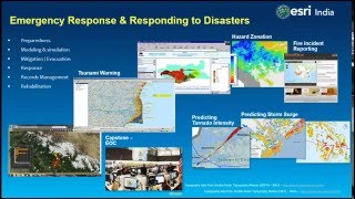
Moving on, let’s investigate the applications of GIS in smart cities. Smart cities utilize technology to improve engagement and efficiency.

How does GIS contribute to real-time monitoring in smart cities?
GIS allows for real-time monitoring of utilities like water, waste, and power, helping cities respond quickly to issues such as leaks or outages.
What about traffic planning? How does that work with GIS?
Good point! Traffic planning benefits from IoT and GIS integration, allowing for the analysis of traffic patterns and optimization of traffic signals to enhance flow.
What role does e-governance play in all this?
E-governance improves access to services for citizens. GIS can visualize where services like parks, libraries, or emergency services are located, making it easy for residents to navigate.
In summary, GIS enhances smart city initiatives through real-time utility monitoring, transportation planning, and e-governance, creating more responsive and engaged urban environments.
Introduction & Overview
Read summaries of the section's main ideas at different levels of detail.
Quick Overview
Standard
Urban planning increasingly relies on Geographic Information Systems (GIS) to model land use, utilities, traffic patterns, and population density, helping in zoning regulations, infrastructure allocation, and urban renewal. The applications of smart cities also include real-time monitoring of utilities, traffic planning using IoT integration, and enhancing e-governance.
Detailed
Urban Planning and Smart Cities
Urban planning has been significantly transformed through the use of Geographic Information Systems (GIS). GIS allows for effective spatial planning by modeling various factors such as land use, utility networks, traffic patterns, and population densities. This technology aids in establishing zoning regulations, allocating infrastructure resources, and executing urban renewal projects efficiently.
Applications in Smart Cities:
GIS technology is crucial in the development of smart cities, offering several applications including:
- Real-time utility monitoring: Facilitates management of water, waste, and power utilities, enhancing operational efficiency.
- Traffic and transportation planning: Integrating Internet of Things (IoT) technologies with GIS helps in analyzing and optimizing traffic flows.
- E-Governance: Leveraging GIS for citizen services mapping improves access to government services, promoting transparency and public participation.
In summary, the integration of GIS in urban planning and the development of smart cities not only enhances the operational aspects of urban management but also improves community engagement and environmental sustainability.
Youtube Videos


Audio Book
Dive deep into the subject with an immersive audiobook experience.
GIS in Urban Planning
Chapter 1 of 2
🔒 Unlock Audio Chapter
Sign up and enroll to access the full audio experience
Chapter Content
GIS enables spatial planning by modeling land use, utilities, traffic patterns, and population density. It helps in zoning regulations, infrastructure allocation, and urban renewal projects.
Detailed Explanation
Geographic Information Systems (GIS) play a crucial role in urban planning by providing a framework for spatial analysis. This means that urban planners can visualize and understand how different elements like land use, utilities, and traffic patterns spatially relate to one another. Through GIS, planners can analyze population density to ensure that there are adequate services and infrastructures, like roads, hospitals, and schools, where they are most needed. Zoning regulations, which dictate how different parts of a city can be used (for example, residential vs. commercial), are informed by insights gained from GIS data, ensuring that the urban landscape is both functional and sustainable.
Examples & Analogies
Imagine a city as a giant puzzle. Each piece of that puzzle represents a different function—homes, businesses, parks, and roads. GIS acts like a set of detailed instructions that helps planners see where each piece fits best, ensuring that people can live, work, and move about efficiently without bumping into problems. For instance, if planners notice a growing population in one area, they could use GIS to find where to build new schools or parks so that residents have access to necessary services.
Applications in Smart Cities
Chapter 2 of 2
🔒 Unlock Audio Chapter
Sign up and enroll to access the full audio experience
Chapter Content
Real-time monitoring of utilities (water, waste, power) Traffic and transportation planning using IoT-GIS integration E-Governance and citizen services mapping.
Detailed Explanation
Smart cities leverage technology, including the Internet of Things (IoT), to improve the efficiency and sustainability of urban services. With real-time monitoring, cities can keep track of utilities like water supply, waste management, and electricity distribution, ensuring they respond quickly to issues like outages or leaks. IoT devices collect data that, when integrated with GIS, reveal traffic patterns and help with transportation planning. This can lead to smarter traffic light systems or optimized public transit routes. Additionally, E-Governance uses GIS to help citizens access services efficiently; for example, citizens can use online maps to find public services or report issues like potholes directly to city officials.
Examples & Analogies
Think of a smart city as a living organism. Just like the human body has systems that work together to maintain health—like the circulatory and nervous systems—smart cities use technology to ensure that everything from water supply to traffic management is in sync. For instance, if a significant part of a city's water system has a leak, real-time monitoring will alert the city services, just like how a human body feels pain in an injury area, prompting immediate attention. This results in quicker responses and ultimately a better quality of life for residents.
Key Concepts
-
GIS: Essential for spatial planning and decision-making in urban contexts.
-
Smart Cities: Urban areas utilizing technology for enhanced efficiency and citizen engagement.
-
E-Governance: Ensures better access to citizen services and community involvement.
Examples & Applications
An example of GIS in urban planning can be seen when a city uses GIS to identify areas that require improved public transportation infrastructure.
In smart cities, real-time monitoring of water supply reduces wastage and enhances management practices, leading to more sustainable urban living.
Memory Aids
Interactive tools to help you remember key concepts
Rhymes
GIS in city planning helps us see, how our urban future can be.
Stories
Imagine a bustling city where the mayor uses GIS to find the perfect place for a new park, ensuring all neighborhoods can enjoy green space.
Memory Tools
GIS: Gather, Inform, Structure.
Acronyms
SMART
Sustainable Management And Real-time Technology.
Flash Cards
Glossary
- GIS
Geographic Information Systems; a framework for gathering, managing, and analyzing spatial and geographic data.
- Smart Cities
Urban areas that use different types of electronic methods and sensors to collect data and manage assets to improve efficiency and quality of life.
- Urban Planning
The process of designing and regulating the use of land and resources in urban areas.
- IoT
Internet of Things; the network of physical devices connected to the internet for collecting and exchanging data.
Reference links
Supplementary resources to enhance your learning experience.