
Water Resource Management
Enroll to start learning
You’ve not yet enrolled in this course. Please enroll for free to listen to audio lessons, classroom podcasts and take practice test.
Interactive Audio Lesson
Listen to a student-teacher conversation explaining the topic in a relatable way.
Groundwater Potential Mapping
🔒 Unlock Audio Lesson
Sign up and enroll to listen to this audio lesson

Today, we will delve into groundwater potential mapping. Can anyone explain what groundwater potential mapping entails?

Is it about finding places where we can extract groundwater efficiently?
Exactly! It uses GIS to combine different thematic layers such as geology, land use, and rainfall. This helps us identify optimal locations for borewells. Why do you think understanding these layers is important?

Because the geology can determine how much water is available and how easily it can be extracted, right?

And certain land uses might affect how efficiently we can collect that water!
That's correct! Remember the acronym GLE—Geology, Land use, and Elevation. These are critical factors in our analysis.

So, can this mapping help prevent over-extraction of groundwater?
Absolutely! By pinpointing zones, we can manage extraction better and contribute to sustainable water practices.
In summary, groundwater potential mapping with GIS is vital for sustainable water management by providing detailed spatial analysis.
Irrigation Planning
🔒 Unlock Audio Lesson
Sign up and enroll to listen to this audio lesson

Next, let’s turn our attention to irrigation planning. How does GIS contribute to designing effective irrigation systems?
It can help in mapping out canal networks based on terrain?
Right! GIS uses Digital Elevation Models. This allows us to visualize how water will flow through a landscape. What is another method for analyzing crop water demand?
I think it’s using satellite data with NDVI?
Correct! NDVI measures vegetation health, which helps assess crop water needs. Does anyone have a guess on why this is crucial?
To ensure crops get enough water and reduce waste?
Exactly! Smart irrigation planning helps maximize efficiency and sustainability in water use. Remember the term SMART—Sustainable, Manageable, Accurate, Responsive, and Timely irrigation planning is key.
To summarize, GIS enhances irrigation planning by integrating DEMs and satellite imagery, ensuring effective and efficient water management.
Introduction & Overview
Read summaries of the section's main ideas at different levels of detail.
Quick Overview
Standard
The section covers how geospatial technologies like GIS play a crucial role in identifying suitable areas for groundwater extraction and designing efficient irrigation systems. It includes discussions on thematic layers utilized in mapping and understanding crop water demands using satellite data.
Detailed
Water Resource Management
In this section, we examine the critical role of geospatial technology, specifically Geographic Information Systems (GIS), in water resource management. The section is divided into two main areas:
- Groundwater Potential Mapping: This involves using thematic layers, such as geology, land use, slope, and rainfall data, to identify areas that are optimal for developing borewells or recharge structures. Understanding the geological and hydrological context is fundamental for effective groundwater management, especially in areas facing scarcity.
- Irrigation Planning: The section elaborates on designing canal networks using Digital Elevation Models (DEMs) and analyzing crop water demand through the Normalized Difference Vegetation Index (NDVI) derived from satellite imagery. Proper irrigation planning ensures sustainable water use and enhances agricultural productivity, aligning with broader objectives of resource conservation and management. In combination, these applications illustrate how modern tools can lead to more informed and sustainable decisions in water resource management.
Youtube Videos

Audio Book
Dive deep into the subject with an immersive audiobook experience.
Groundwater Potential Mapping
Chapter 1 of 2
🔒 Unlock Audio Chapter
Sign up and enroll to access the full audio experience
Chapter Content
Using thematic layers like geology, land use, slope, and rainfall, GIS helps map areas suitable for borewell or recharge structure development.
Detailed Explanation
Groundwater potential mapping involves using Geographic Information Systems (GIS) to analyze various geographical factors that influence where groundwater can be found and accessed. Thematic layers in GIS include different data sets, such as geological formations, patterns of land use, the slope of the land, and rainfall statistics. By layering these different factors within a GIS, engineers can identify the most suitable locations for drilling borewells (for extracting groundwater) or constructing recharge structures (to replenish aquifers). This mapping is crucial for effective water resource management, ensuring that water extraction does not exceed the natural replenishment rate.
Examples & Analogies
Imagine trying to bake a cake without knowing the right ingredients and their quantities. Similarly, knowing where to drill for water without the right geographical data is like baking without a recipe. Just like how a good recipe guides a baker through the process, groundwater potential mapping provides engineers with a clear and informed path to find water efficiently.
Irrigation Planning
Chapter 2 of 2
🔒 Unlock Audio Chapter
Sign up and enroll to access the full audio experience
Chapter Content
• Canal network design using DEM
• Crop water demand analysis using NDVI from satellite data
Detailed Explanation
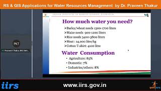
Irrigation planning involves designing efficient systems for delivering water to crops, and GIS plays a crucial role. First, Digital Elevation Models (DEMs) are used to design canal networks that deliver water where it is needed most, considering the terrain's features. This ensures that water flows naturally without excessive pumping. Second, GIS utilizes NDVI (Normalized Difference Vegetation Index), obtained from satellite data, to analyze crop water demand. NDVI helps in assessing the health of crops based on their color characteristics in satellite images, indicating how much water they need for optimal growth. This two-fold approach ensures that irrigation is both effective and sustainable.
Examples & Analogies
Think of irrigation planning like laying out a water park. Just as you need to strategically position water slides and pools for maximum fun, farmers must plan how to distribute water through a network of canals to maximize crop yield. DEMs help determine where to place those slides (canals), while NDVI tells the farmers which areas need more water, similar to checking which pool is more crowded and needs an extra splash of water.
Key Concepts
-
Groundwater Potential Mapping: Identifying locations suitable for groundwater extraction using GIS.
-
Irrigation Planning: Utilizing GIS to design irrigation systems based on terrain and crop demands.
Examples & Applications
Using GIS to analyze rainfall patterns and spot areas with high groundwater potential.
Employing NDVI data from satellite images to calculate precise irrigation needs for different crops.
Memory Aids
Interactive tools to help you remember key concepts
Rhymes
When mapping groundwater, don’t forget the layer, geology's your key, it could be a lifesaver!
Stories
Imagine a farmer using a magic map (GIS) that shows him where the best water sources lie, helping him water his crops just right, leading to a fruitful harvest.
Memory Tools
Remember PIES for planning irrigation: Plan, Integrate, Execute, and Sustain.
Acronyms
GEMS - Groundwater, Elevation, Mapping, Sustainability.
Flash Cards
Glossary
- Groundwater Potential Mapping
The process of identifying suitable locations for groundwater extraction using spatial analyses of various thematic layers.
- Geographic Information Systems (GIS)
A technology that allows for the collection, analysis, and visualization of spatial and geographic data.
- Digital Elevation Models (DEMs)
3D representations of terrain used in assessing topography for planning and analysis.
- Normalized Difference Vegetation Index (NDVI)
An index used for measuring vegetation health and estimating crop water demands.
Reference links
Supplementary resources to enhance your learning experience.