
Route Alignment and Highway Engineering
Enroll to start learning
You’ve not yet enrolled in this course. Please enroll for free to listen to audio lessons, classroom podcasts and take practice test.
Interactive Audio Lesson
Listen to a student-teacher conversation explaining the topic in a relatable way.
Fundamentals of GNSS and GIS
🔒 Unlock Audio Lesson
Sign up and enroll to listen to this audio lesson

Welcome class! Today, we'll discuss how Global Navigation Satellite Systems, or GNSS, are used in road planning. Can anyone tell me what GNSS is?

Isn't it something that helps with GPS and satellite signals?
Exactly! GNSS helps us determine precise locations on Earth, which is vital for civil engineering. Now, how about GIS? What does it do?

GIS helps us analyze geographical data and visualize it, right?
Perfect! GNSS provides the data we need, while GIS allows us to evaluate it for various alignment options based on different criteria, such as slope or soil type. Remember the acronym 'GAP' – GNSS for location, Analysis by GIS, and Planning our routes.

So, if we use GAP, we can make better road designs?
Yes! That's the essence of using these technologies. To recap, GNSS provides accurate ground control points, while GIS evaluates multiple alignment options.
Multi-Criteria Decision Analysis (MCDA)
🔒 Unlock Audio Lesson
Sign up and enroll to listen to this audio lesson

Let's dive deeper into Multi-Criteria Decision Analysis, or MCDA. Why do you think we need MCDA in highway engineering?

Maybe to balance different factors like cost and environmental impact?
Exactly! MCDA helps engineers weigh factors like land slope, soil stability, land acquisition costs, and environmental sensitivity. It's all about making informed choices for the best route alignment.
How do we actually rank these factors?
Great question! We can layer these datasets in GIS to visualize and compare them. This helps us see which options meet our criteria best. Remember: 'Layering for Clarity'.
Sounds like a lot of data to manage!
It is, but that's where the power of GIS shines. To summarize, MCDA allows for comprehensive evaluation of different options, enhancing decision-making in highway planning.
3D Terrain Modeling in Design
🔒 Unlock Audio Lesson
Sign up and enroll to listen to this audio lesson
Now, let’s talk about how 3D Terrain Modeling plays a role in highway engineering. Why do you think 3D modeling is useful?
It probably helps engineers understand the landscape better.
Exactly! Digital Elevation Models or DEMs help visualize the terrain's features. What kind of topographical elements do you think we analyze?
Maybe slope steepness and potential obstacles?
Yes, and we can identify areas that may require cuttings or fillings to minimize environmental disruption. The phrase 'Shape and Store' can remind us of how we shape the landscape with terrain modeling.
So, 3D models help optimize where the road should go?
Right again! In summary, 3D modeling allows for thorough visualization and aids in optimizing route design for highway engineering.
Introduction & Overview
Read summaries of the section's main ideas at different levels of detail.
Quick Overview
Standard
In 'Route Alignment and Highway Engineering', GNSS and GIS are pivotal in determining optimal highway alignments by assessing various factors including land slope, soil stability, and cost. The use of 3D Terrain Modeling also aids engineers in visualizing topography for effective route design.
Detailed
Route Alignment and Highway Engineering
Overview
This section highlights the integral role of GNSS (Global Navigation Satellite Systems) and GIS (Geographic Information Systems) in highway engineering, specifically in route alignment. As civil engineering projects become increasingly complex, the necessity for precise planning tools is paramount.
Key Components
- GNSS is utilized for collecting ground control points that inform engineers about the terrain. This data is crucial for accurate positioning and alignment considerations.
- GIS allows for the evaluation of various alignment options, taking into account multiple datasets including slope, soil type, and environmental constraints. This multi-criteria approach leads to better decision-making in route selection.
- Multi-Criteria Decision Analysis (MCDA) is employed to assess these options, ensuring that all ecological and economic factors are considered before finalizing a route.
- 3D Terrain Modeling with Digital Elevation Models (DEMs) enhances understanding of the topography, allowing for optimized designs that minimize environmental impact while meeting safety standards.
Significance
In summary, the effective integration of GNSS, GIS, and 3D modeling tools not only streamlines the highway planning process but also contributes to the sustainability and efficiency of civil engineering projects overall.
Youtube Videos


Audio Book
Dive deep into the subject with an immersive audiobook experience.
GNSS and GIS in Road Planning
Chapter 1 of 3
🔒 Unlock Audio Chapter
Sign up and enroll to access the full audio experience
Chapter Content
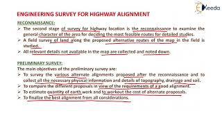
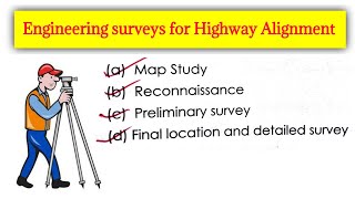
Highway engineers use GNSS to collect ground control points, and GIS to evaluate multiple alignment options based on slope, soil type, and environmental constraints.
Detailed Explanation
In road planning, highway engineers utilize two key geospatial technologies: GNSS (Global Navigation Satellite System) and GIS (Geographic Information Systems). GNSS helps in accurately collecting vital points on the ground, referred to as ground control points. These points serve as reference markers in the planning process. Meanwhile, GIS aids engineers in assessing various potential routes by considering critical factors such as terrain slope, soil characteristics, and environmental limitations. By analyzing this data, engineers can identify the most viable and sustainable highway alignments for new roads.
Examples & Analogies
Imagine you are in a new city and need to choose the best route to your destination. You would likely look at a map to see the topography, any rivers, and whether the roads are smooth or rocky. In the same way, engineers use GIS tools to visualize land and make informed decisions about the best path for a highway, avoiding steep slopes or sensitive lands, just as you would avoid roads that are closed due to construction.
Multi-Criteria Decision Analysis (MCDA)
Chapter 2 of 3
🔒 Unlock Audio Chapter
Sign up and enroll to access the full audio experience
Chapter Content
GIS enables MCDA by layering multiple datasets such as:
• Land slope
• Soil stability
• Land acquisition cost
• Environmental sensitivity
Detailed Explanation
Multi-Criteria Decision Analysis (MCDA) is a method that helps engineers make complex routing decisions by compiling information from various datasets using GIS. This can include factors like land slope, which indicates how steep the terrain is; soil stability, which assesses how reliable the ground is for building; land acquisition costs, which estimate financial implications for acquiring land; and environmental sensitivity, which highlights areas that need protection. By layering these datasets, engineers can evaluate the trade-offs of different alignment choices and select the one that meets all necessary criteria.
Examples & Analogies
Think of choosing a vacation spot where you consider multiple factors – travel cost, hotel quality, climate, and activities available. Just like you would weigh which destination offers the best overall experience based on these factors, highway engineers strategically overlay different map layers in GIS to decide which road route will balance costs, safety, and environmental impact best.
3D Terrain Modeling
Chapter 3 of 3
🔒 Unlock Audio Chapter
Sign up and enroll to access the full audio experience
Chapter Content
Digital Elevation Models (DEMs) and contours help visualize the topography for optimized route design.
Detailed Explanation
3D terrain modeling is an advanced visual representation of the landscape, crafted using Digital Elevation Models (DEMs) and contour lines. DEMs provide a comprehensive view of elevation changes over a geographic area, allowing engineers to see hills, valleys, and slopes in three dimensions. Contour lines, which connect points of equal elevation on a map, further help in understanding how steep or flat the terrain is. Together, these tools enable engineers to create effective and safe highway designs by optimizing routes that minimize erosion, reduce environmental damage, and ensure driver safety.
Examples & Analogies
Imagine a sculptor using a 3D model to visualize their sculpture. The model helps them understand how to carve and what shapes to create. Similarly, highway engineers use 3D models of the terrain to visualize how a new road will interact with the landscape, allowing them to design safer and more efficient highways that adapt beautifully to the natural environment.
Key Concepts
-
GNSS: A technology used for accurate location positioning in civil engineering.
-
GIS: A powerful tool for analyzing spatial data relevant to route planning.
-
MCDA: An evaluation method used to balance multiple factors such as cost and environmental impact in design.
-
3D Terrain Modeling: Visual representation of terrain that aids in route optimization.
Examples & Applications
Using GNSS data, engineers can mark out boundaries for a new highway.
MCDA can help in deciding between two potential routes based on cost-efficiency and environmental sensitivity.
Memory Aids
Interactive tools to help you remember key concepts
Rhymes
In planning roads and routes, we look for clues, GNSS and GIS lead us to choose.
Stories
Imagine a highway engineer named Alex, armed with GNSS and GIS tools. Alex uses these to navigate through mountains and valleys, ensuring the road is safe and efficient before ever laying a single stone.
Memory Tools
Remember the acronym 'GAP' for GNSS, Analysis by GIS, and Planning routes to optimize highway design.
Acronyms
MCDA - Multi-Criteria Decision Analysis helps balance Criteria like Cost, Stability, Environment.
Flash Cards
Glossary
- GNSS
Global Navigation Satellite Systems, a satellite-based system for determining precise location on Earth.
- GIS
Geographic Information Systems, software used for analyzing and visualizing geographic data.
- MCDA
Multi-Criteria Decision Analysis, a process used to evaluate multiple conflicting criteria in decision-making.
- Digital Elevation Model (DEM)
A 3D representation of terrain surfaces, used for analyzing topographical features.
Reference links
Supplementary resources to enhance your learning experience.