
Land Use and Land Cover Mapping
Enroll to start learning
You’ve not yet enrolled in this course. Please enroll for free to listen to audio lessons, classroom podcasts and take practice test.
Interactive Audio Lesson
Listen to a student-teacher conversation explaining the topic in a relatable way.
Importance of Land Use and Land Cover Mapping
🔒 Unlock Audio Lesson
Sign up and enroll to listen to this audio lesson

Today, we're diving into land use and land cover mapping and its importance in civil engineering. Can anyone explain why LULC mapping might be vital before starting a project?

It helps engineers understand the current environment!
Exactly! Understanding existing features like vegetation and urban areas is crucial for assessing environmental impacts. This helps ensure sustainable practices in urban planning. Can anyone think of a specific example where this might be applied?

Maybe in a new housing development project?
Great example! Before proceeding with new developments, LULC mapping informs about potential impacts on the ecosystem, allowing better planning.

How does it relate to environmental assessments?
LULC mapping directly supports environmental impact assessments by identifying land features that will be affected. This is crucial to comply with regulations and make informed decisions. Remember, LULC is all about creating a balance between development and environmental sustainability. Does anyone have questions?

So we can avoid making projects in sensitive ecological areas?
Correct! By using LULC mapping, engineers can pinpoint ecological sensitivities and avoid detrimental impacts. This shields the environment while still facilitating necessary urban development.
Techniques Used in LULC Mapping
🔒 Unlock Audio Lesson
Sign up and enroll to listen to this audio lesson

Now, let’s explore the techniques used for LULC mapping. What is one way engineers can gather data about land features?
They can use satellite images!
Exactly! Remote sensing imagery from satellites like Landsat or Sentinel provides detailed insights into land cover. What types of data collection techniques can we categorize for processing these images?
Supervised and unsupervised classification?
Right! Supervised classification uses training data to categorize the imagery, while unsupervised classification identifies patterns without pre-labeled data. How do these techniques benefit us in engineering?
They help make accurate maps to see different land uses.
Exactly! Integrating these techniques into GIS leads to valuable thematic maps that aid in analysis and decision-making. Can anyone summarize how these techniques contribute to effective LULC mapping?
They provide detailed insights on land that help in urban planning and environmental assessments.
Great summary! Techniques like remote sensing and GIS enhance our understanding of land use, crucial for making informed decisions in civil engineering.
Applications of LULC Mapping
🔒 Unlock Audio Lesson
Sign up and enroll to listen to this audio lesson
Let’s now turn to the applications of LULC mapping. Who can list a few real-world applications in civil engineering?
Urban expansion studies and flood risk mapping!
Excellent! Urban expansion studies help track how cities grow, while flood risk mapping identifies vulnerable areas. What other applications can you think of?
Monitoring environmental degradation?
Very good! Monitoring environmental degradation allows us to address and manage negative changes to land use effectively. Can you think of why these applications matter in the long term?
To create sustainable cities and protect environments!
Absolutely! By employing LULC mapping, civil engineers can ensure that urban development aligns with sustainability goals, ultimately benefiting society and the environment.
Introduction & Overview
Read summaries of the section's main ideas at different levels of detail.
Quick Overview
Standard
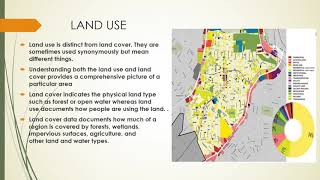
Land use and land cover (LULC) mapping is crucial for civil engineers as it allows for a comprehensive understanding of the physical environment prior to project initiation. By identifying various land features, engineers can conduct environmental impact assessments and make informed urban planning decisions.
Detailed
Land Use and Land Cover Mapping
Land use and land cover (LULC) mapping serves a critical function in civil engineering by providing essential insights into the physical environment before a project begins. Understanding existing features such as vegetation, urban areas, water bodies, and barren lands allows civil engineers to assess potential impacts and plan accordingly. LULC mapping supports environmental impact assessments and urban planning initiatives, ensuring that infrastructure development considers ecological sustainability.
Importance in Civil Engineering
LULC mapping enhances decision-making in civil engineering through:
- Environmental Impact Assessments: Evaluating potential impacts of proposed projects on existing land cover.
- Urban Planning: Informing zoning regulations and land use allocations based on current characteristics of the area.
Techniques Used in LULC Mapping
Several advanced techniques are employed for accurate LULC mapping:
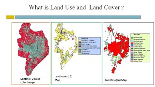
- Remote Sensing Imagery: Involves using satellite images from platforms like Landsat and Sentinel to gather information on land features.
- Classification Techniques: Utilizes both supervised and unsupervised methods to categorize various land cover types.
- Integration with GIS: Combining remote sensing data with Geographic Information Systems (GIS) produces thematic maps that visualize land cover changes effectively.
Applications of LULC Mapping
LULC mapping has various practical applications in civil engineering, including:
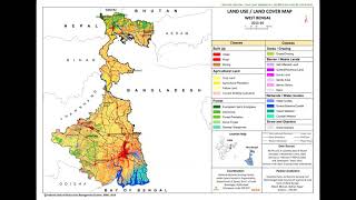
- Urban Expansion Studies: Monitoring how urban areas grow and change over time.
- Flood Risk Mapping: Identifying areas prone to flooding to enhance infrastructure resilience.
- Environmental Degradation Monitoring: Tracking changes in ecosystems and land areas to mitigate degradation.
Youtube Videos


Audio Book
Dive deep into the subject with an immersive audiobook experience.
Importance in Civil Engineering
Chapter 1 of 3
🔒 Unlock Audio Chapter
Sign up and enroll to access the full audio experience
Chapter Content
Land use/land cover (LULC) mapping helps civil engineers understand the existing physical environment before undertaking a project. It identifies features such as vegetation, urban areas, water bodies, and barren lands, facilitating environmental impact assessments and urban planning.
Detailed Explanation
LULC mapping is crucial in civil engineering as it provides vital information about the environment where a project will take place. By identifying different types of land cover—like forests, urban areas, and water bodies—engineers can assess how a project might affect the area. Understanding these features helps predict potential environmental impacts and informs urban planning decisions.
Examples & Analogies
Imagine you're planning to build a playground in a neighborhood. Before starting, you need to know what is already there: Are there trees that need to be preserved? Is the land prone to flooding? Just like checking out a backyard before a big barbecue to ensure there’s space for everything, LULC mapping tells engineers about the existing conditions.
Techniques Used in LULC Mapping
Chapter 2 of 3
🔒 Unlock Audio Chapter
Sign up and enroll to access the full audio experience
Chapter Content
• Remote sensing imagery (from satellites like Landsat, Sentinel)
• Classification techniques (supervised and unsupervised)
• Integration with GIS to produce thematic maps
Detailed Explanation
Several techniques are employed for effective LULC mapping. Remote sensing imagery from satellites like Landsat and Sentinel captures large areas of land, providing detailed images that reveal surface characteristics. Classification techniques—both supervised (where a model is trained on labeled data) and unsupervised (which clusters data based on intrinsic characteristics)—are used to categorize the land. Finally, Geographic Information Systems (GIS) enable the integration of these data, creating thematic maps that illustrate land use and cover clearly.
Examples & Analogies
Think of LULC mapping like preparing a team for a sports match. You need accurate information (like satellite imagery) to know the field conditions. Classification techniques are like training players: some are trained in specific positions (supervised) while others learn on the fly (unsupervised). Finally, combining this with a strategy (GIS) helps visualize and plan how to play the game effectively.
Applications of LULC Mapping
Chapter 3 of 3
🔒 Unlock Audio Chapter
Sign up and enroll to access the full audio experience
Chapter Content
• Urban expansion studies
• Identifying encroachments
• Flood risk mapping
• Monitoring environmental degradation
Detailed Explanation
LULC mapping has multiple practical applications. Urban expansion studies assess how cities grow and change over time. Identifying encroachments involves detecting unauthorized land use, which is critical for urban planning and legal compliance. Flood risk mapping helps in assessing areas that may be prone to flooding by analyzing the landscape and existing water bodies. Finally, monitoring environmental degradation keeps track of changes in ecosystems, informing conservation efforts.
Examples & Analogies
Imagine a city manager who needs to understand how their town is growing. They would use LULC mapping like a gardener uses a map of their garden layout. Just as a gardener needs to know which flowers are flourishing or wilting to take care of them, urban planners use LULC data to monitor growth patterns and take necessary actions like protecting certain areas from overdevelopment.
Key Concepts
-
LULC Mapping: A method for understanding how land is used and covered, crucial for sustainable urban development.
-
Remote Sensing: A technique used to gather data about the earth's surface without direct contact.
-
GIS: A platform that integrates various data types for spatial analysis and visualization.
-
Environmental Impact Assessment: A systematic process to evaluate the likely environmental impacts of proposed projects.
Examples & Applications
A civil engineering project in a new urban area utilizes LULC mapping to assess the impact of proposed buildings on local ecosystems.
Flood risk mapping is employed in a city prone to flooding, allowing engineers to design drainage systems more effectively.
Memory Aids
Interactive tools to help you remember key concepts
Rhymes
Mapping land use, how it’s grown, helps avoid impacts unknown.
Stories
Once there was a city where they mapped the land, understanding each area, plant, and strand. Builders would plan with care, knowing the risks laid bare.
Memory Tools
Remember 'MAPS' for LULC: M (Mapping), A (Assessments), P (Planning), S (Sustainability).
Acronyms
LULC
Land Use
Land Cover.
Flash Cards
Glossary
- Land Use
Refers to the way land is utilized by humans, including residential, commercial, agricultural, and recreational purposes.
- Land Cover
Describes the physical material at the surface of the earth, such as vegetation, urban areas, and water bodies.
- Remote Sensing
The acquisition of information about an object or phenomenon without making physical contact, often using satellite or aerial imagery.
- Geographic Information Systems (GIS)
A framework for gathering, managing, and analyzing spatial and geographic data.
- Environmental Impact Assessment (EIA)
A process that evaluates the potential environmental effects of a proposed project or development.
Reference links
Supplementary resources to enhance your learning experience.