
Integration of UAV (Drone) Data in Civil Projects
Enroll to start learning
You’ve not yet enrolled in this course. Please enroll for free to listen to audio lessons, classroom podcasts and take practice test.
Interactive Audio Lesson
Listen to a student-teacher conversation explaining the topic in a relatable way.
Advantages of UAV in Civil Projects
🔒 Unlock Audio Lesson
Sign up and enroll to listen to this audio lesson

Today, we'll delve into how UAVs, or drones, enhance civil engineering projects. To start, can anyone tell me the primary advantages of using drones in our field?

I think drones provide high-resolution images, right?
Exactly! High-resolution orthophotos allow engineers to see detailed maps of terrains. It's crucial for planning. Can anyone think of another advantage?

They can save time and cut costs compared to traditional surveys.
Right! UAVs indeed speed up the surveying process and are often more budget-friendly. This efficiency can be extremely beneficial for project timelines. Let's not forget their capability for accurate volume estimations. Why do you think that matters?

It helps with managing materials better and avoiding overages.
That’s spot on! Proper volume estimation ensures we manage resources effectively. Great discussion on advantages!
Applications of UAV in Civil Projects
🔒 Unlock Audio Lesson
Sign up and enroll to listen to this audio lesson

Building upon the advantages, let's explore how UAV technology is applied in civil engineering. Can anyone name an application?

I believe they are used for corridor mapping for roads and railways.
Correct! Corridor mapping allows for efficient planning. Another application I’d like to highlight is project documentation. Student_1, why do you think this is important?
It helps keep track of progress and ensure accountability during construction.
Exactly! Documentation is essential for transparency in projects. Lastly, UAVs excel at site inspections in hard-to-reach places. Can anyone think of a scenario where this would be advantageous?
For instance, inspecting cliffs or areas with potential landslides.
Yes, great example! Drones provide safety and accessibility in challenging terrains. Excellent discussion on UAV applications!
Introduction & Overview
Read summaries of the section's main ideas at different levels of detail.
Quick Overview
Standard
This section outlines the advantages of using UAV (drone) data in civil engineering projects, including high-resolution orthophotos, cost efficiency, and rapid data gathering, alongside key applications such as corridor mapping, project documentation, and site inspections in difficult-to-access areas.
Detailed
Integration of UAV (Drone) Data in Civil Projects
Overview
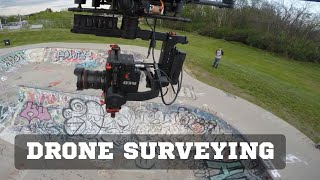
Drones, also known as Unmanned Aerial Vehicles (UAVs), play a pivotal role in modern civil engineering projects by collecting high-resolution data quickly and cost-effectively. The integration of such data into civil projects addresses complex surveying needs while enhancing accuracy and decision-making processes.
Advantages
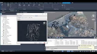
- High-resolution orthophotos: Drones can capture detailed aerial imagery that provides an accurate representation of the terrain, essential for planning and analysis.
- Quick and cost-effective surveys: UAVs significantly reduce the time and cost required for traditional surveying methods, leading to increased project efficiency.
- Accurate volume estimation: Drones allow for precise measurement of stockpiles, excavations, and site volumes, improving the management of materials and resources.
Applications
- Corridor mapping: UAVs can map out corridors for roads and railways, identifying potential obstacles and optimizing route planning.
- Project documentation and reporting: Drone imagery can serve as an effective means of documenting project progress, ensuring transparency and accountability in civil engineering activities.
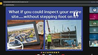
- Site inspection in hard-to-reach areas: Drones provide access to difficult terrains, enabling inspections in locations that may be hazardous or inaccessible to human teams, thus enhancing safety.
Youtube Videos


Audio Book
Dive deep into the subject with an immersive audiobook experience.
Advantages of UAV Data
Chapter 1 of 2
🔒 Unlock Audio Chapter
Sign up and enroll to access the full audio experience
Chapter Content
- High-resolution orthophotos
- Quick and cost-effective surveys
- Accurate volume estimation of stockpiles or excavations
Detailed Explanation
This chunk outlines the key benefits of using UAV (drone) data in civil engineering projects. The first advantage is high-resolution orthophotos, which are detailed aerial images that provide accurate visual data about the terrain and existing conditions. The second advantage is the speed and cost-effectiveness of surveys conducted using drones; they can cover large areas much faster than traditional surveying methods, which saves time and reduces labor costs. Lastly, drones allow for precise volume estimations, which can be crucial for projects involving material management like excavations or stockpiling, as accurate measurements can inform project planning and budget management.
Examples & Analogies
Think of using UAVs like using a smartphone camera versus a traditional camera. When you take photos of a construction site with your smartphone (UAV), you can quickly capture high-quality images that provide a clear overview of the project, similar to how high-resolution orthophotos provide clarity in mapping. Plus, just as you can send those images to your friends instantly, UAVs perform quick surveys that save time and money, much like how texting is faster and cheaper than making phone calls.
Applications of UAV Data
Chapter 2 of 2
🔒 Unlock Audio Chapter
Sign up and enroll to access the full audio experience
Chapter Content
- Corridor mapping for roads and railways
- Project documentation and reporting
- Site inspection in hard-to-reach areas
Detailed Explanation
This chunk discusses the practical uses of UAV data in civil engineering. Corridor mapping is an application where drones are utilized to create a detailed layout for roads and railways, ensuring that planners have accurate data on terrain and potential obstacles. Project documentation refers to the organized records of construction progress or stages, where drones provide continual updates and visual proof of site conditions. Lastly, drones enable site inspections in areas that are difficult to access, such as steep slopes or remote locations; they can safely capture data without putting personnel at risk or requiring extensive resources.
Examples & Analogies
Imagine trying to read a map while hiking on a steep mountain trail. A UAV (drone) acts like a scout that flies ahead to gather detailed information about your path, helping you navigate the terrain (corridor mapping). Similarly, when you take photos on a hike to document your journey and share with friends, drones help capture and report ongoing construction work (project documentation), and when the terrain becomes too treacherous, the drone can inspect it instead of putting you in danger (site inspection).
Key Concepts
-
UAVs enhance data collection: Drones provide high-resolution imagery that is crucial for planning and decision-making.
-
Cost-effectiveness: UAVs often reduce surveying costs compared to traditional methods.
-
Implementation in various applications: UAVs are utilized for corridor mapping, project documentation, and inspecting hard-to-reach sites.
Examples & Applications
A construction company uses UAVs to map out a new railway corridor, identifying obstacles and planning routes more efficiently.
During a building project, drones capture high-resolution images for documenting progress, which are shared with stakeholders.
Memory Aids
Interactive tools to help you remember key concepts
Rhymes
Drones in the air, high-tech and fair, / Mapping our projects with utmost care.
Stories
Imagine a construction manager using a drone to survey a site. The drone flies over the area, revealing everything from high buildings to hidden obstacles, helping them plan the project effectively.
Memory Tools
D.A.R.E: Drones for Aerial Reconnaissance and Estimation.
Acronyms
UAV
Unmanned Aerial Vehicle = 'U Can Access Views' that give insights.
Flash Cards
Glossary
- UAV (Unmanned Aerial Vehicle)
An aircraft that operates without a human pilot onboard, commonly known as a drone.
- Orthophoto
An aerial photograph geometrically corrected to create a map-like representation.
Reference links
Supplementary resources to enhance your learning experience.