
Urban Flood Management and Sponge Cities
Enroll to start learning
You’ve not yet enrolled in this course. Please enroll for free to listen to audio lessons, classroom podcasts and take practice test.
Interactive Audio Lesson
Listen to a student-teacher conversation explaining the topic in a relatable way.
Introduction to Urban Flood Management
🔒 Unlock Audio Lesson
Sign up and enroll to listen to this audio lesson

Today, we will explore the challenges of urban flooding and effective management strategies. Why do you think urban areas are particularly prone to flooding?

I think it's because there are a lot of impervious surfaces, like roads and buildings.
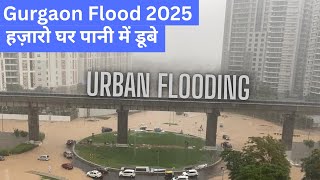
Exactly! These surfaces prevent water from soaking into the ground, leading to increased runoff. Can anyone think of a recent flood event in an urban area?

The flooding in New York City last summer was really severe.
Great example, Student_2! Events like those highlight the importance of effective flood management. One of the methods we can use is the concept of sponge cities.
What is a Sponge City?
🔒 Unlock Audio Lesson
Sign up and enroll to listen to this audio lesson

A sponge city is designed to absorb rainwater efficiently. What features do you think these cities would have? Let's brainstorm a few.

Maybe they would have a lot of parks with rain gardens.

And green roofs on buildings!
Absolutely! Parks, rain gardens, and green roofs are all vital components. They not only manage stormwater but also improve air quality and enhance biodiversity. Now, how does GIS play a role in implementing these concepts?
GIS Applications in Sponge Cities
🔒 Unlock Audio Lesson
Sign up and enroll to listen to this audio lesson
Now that we know about sponge cities, let's discuss how GIS helps in their planning. Can anyone explain how GIS can contribute to urban flood management?
It can help map drainage systems and see where water tends to collect.
Exactly! GIS can identify flood sinks and chokepoints by integrating drainage maps, rainfall data, and terrain models. This is critical for creating effective urban designs. It's really about making our cities more resilient!
So GIS helps planners know where to build these sponge city features?
Yes! It enables better decision-making in the placement of green infrastructure to maximize flood absorption and management. Let's summarize what we've learned today: sponge cities utilize green infrastructure, and GIS is pivotal in planning these solutions.
Introduction & Overview
Read summaries of the section's main ideas at different levels of detail.
Quick Overview
Standard
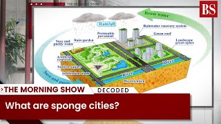
Urban flood management is crucial as cities face increasing flooding risks due to climate change and urbanization. The concept of sponge cities employs permeable surfaces, green roofs, and urban wetlands to absorb and reuse rainwater effectively. GIS technologies play a vital role in modeling flood patterns and designing solutions for urban resilience.
Detailed
Urban Flood Management and Sponge Cities
Urban flood management is increasingly essential due to the rising incidences of flooding driven by climate change and urban development. The section introduces the concept of sponge cities, which are designed to absorb rainwater through permeable surfaces and innovative green infrastructure such as green roofs and urban wetlands. This approach aims to manage stormwater sustainably while enhancing urban green spaces.
Key Components of Sponge Cities
- Permeable Surfaces: Utilizing surfaces that allow rainwater to infiltrate and reduce runoff.
- Green Roofs: Installing vegetation on rooftops to absorb rainwater.
- Urban Wetlands: Creating wetland areas within urban spaces to capture and store excess rainwater.
Role of GIS
GIS technologies are instrumental in:
- Integrating drainage maps, rainfall data, and terrain models to model flood inundation areas.
- Identifying flood sinks and chokepoints, helping planners mitigate flooding risk effectively.
In summary, sponge cities represent a proactive and innovative approach to urban flood management, enhancing city resilience through sustainable practices.
Youtube Videos


Audio Book
Dive deep into the subject with an immersive audiobook experience.
Urban Flood Modelling
Chapter 1 of 2
🔒 Unlock Audio Chapter
Sign up and enroll to access the full audio experience
Chapter Content
• Integration of drainage maps, rainfall data, and terrain models
• Identification of flood sinks and chokepoints
Detailed Explanation
Urban flood modeling involves the use of various data sources to predict and manage flooding in urban areas. The key elements of this process include:
1. Integration of Drainage Maps: These maps show how water flows through the city's drainage system. By understanding the drainage layout, engineers can assess how different parts of the city might be affected by heavy rain.
2. Rainfall Data: This includes historical data on rainfall patterns and projections for future weather events. Accurate rainfall data is vital for predicting potential flooding levels.
3. Terrain Models: These models illustrate the physical landscape of the area, including elevations and depressions that can affect how water collects and moves during rainstorms.
4. Identification of Flood Sinks and Chokepoints: Flood sinks are low-lying areas where water accumulates, while chokepoints are locations where water flow is restricted, which can exacerbate flooding. Identifying these points helps in strategizing flood management efforts effectively.
Examples & Analogies
Imagine planning a big event outdoors, like a concert, and you have to consider where rainwater will gather if it rains. You'd check the layout of the area (terrain models), look at the forecast for when it might rain (rainfall data), and understand how the drainage system works so that water can be redirected effectively (drainage maps). By spotting the areas where water could collect (flood sinks) or where there may be barriers (chokepoints), you can plan around those issues and keep the concert site safe.
Designing Sponge Cities
Chapter 2 of 2
🔒 Unlock Audio Chapter
Sign up and enroll to access the full audio experience
Chapter Content
A “sponge city” uses permeable surfaces, green roofs, and urban wetlands to absorb and reuse rainwater. GIS is used for:
• Siting of rain gardens
• Runoff modeling
• Storage tank planning
Detailed Explanation
The concept of 'sponge cities' focuses on creating urban environments that can absorb and manage rainfall effectively, reducing the risk of flooding. Here’s how this is achieved:
1. Permeable Surfaces: These are surfaces that allow water to pass through them, soaking into the ground rather than running off into drainage systems. Examples include porous pavements or gravel areas.
2. Green Roofs: Roofs that are partially or completely covered with vegetation can absorb rainwater, reduce runoff, and help to cool the building.
3. Urban Wetlands: These are natural areas designed to manage excess stormwater by acting like a sponge, filtering water and providing habitat.
4. GIS in Design: Geographic Information Systems (GIS) help planners identify suitable locations for rain gardens (areas with plants that can absorb rain), model how water will move across the urban landscape (runoff modeling), and strategize where to put storage tanks for holding excess rainwater until it can evaporate or be reused (storage tank planning). This integrated approach aims to create smarter, more resilient cities.
Examples & Analogies
Think of a sponge that soaks up spills on your countertop. Just like a sponge can absorb water to prevent messes, a sponge city is designed to soak up rainwater to keep the urban area dry during storms. Imagine if your neighborhood had special gardens that naturally collected rain (rain gardens), rooftops covered in plants that drank up excess water (green roofs), and small lakes that stored rainwater for later use (urban wetlands). By using technology like GIS, city planners can pinpoint the best spots to create these features, ensuring that when it rains, the city won't flood – just like a well-placed sponge keeps your kitchen tidy.
Key Concepts
-
Urban Flood Management: Strategies to mitigate flood risk in cities.
-
Sponge City: A city with features that enhance rainwater absorption.
-
GIS Role: Use of GIS to analyze flood patterns and design effective infrastructure.
Examples & Applications
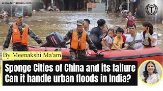
Example of sponge cities, like those implemented in areas of China, which utilize features like green roofs and permeable roads to mitigate urban flooding.
The use of GIS technology to model drainage patterns in urban environments enables planners to prepare for and respond to flood events.
Memory Aids
Interactive tools to help you remember key concepts
Rhymes
In a sponge city, rain's a friend, absorb it well, let the runoff end.
Stories
Once, in a city named Drizzleville, every raindrop was caught by gardens and roofs, as if nature itself had begun to weave a tapestry, preventing floods, and enhancing its beauty.
Memory Tools
S.P.O.N.G.E. for Sponge: Sustainable Planting Options Nurturing Green Environments.
Acronyms
S.P.A.C.E - Sponge City Features
Sustainable
Permeable
Absorbent
Culturally enriching
and Eco-friendly.
Flash Cards
Glossary
- Urban Flood Management
Strategies and methods to prevent or mitigate flooding in urban areas.
- Sponge City
A city designed to absorb rainwater through permeable surfaces and green infrastructure.
- GIS (Geographic Information Systems)
Technology that analyzes and represents spatial data for decision-making.
- Permeable Surfaces
Surfaces designed to allow water to infiltrate the ground.
Reference links
Supplementary resources to enhance your learning experience.