
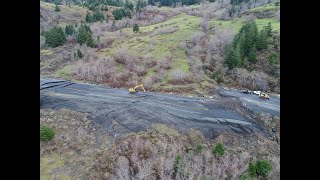
Slope Stability and Landslide Monitoring
Enroll to start learning
You’ve not yet enrolled in this course. Please enroll for free to listen to audio lessons, classroom podcasts and take practice test.
Interactive Audio Lesson
Listen to a student-teacher conversation explaining the topic in a relatable way.
DEM Analysis
🔒 Unlock Audio Lesson
Sign up and enroll to listen to this audio lesson

Today, we are going to discuss DEM analysis. Can anyone tell me what a Digital Elevation Model is?

Isn't it a 3D model that represents the Earth's surface?
Exactly! DEMs are used to create detailed elevation data for large areas. They help us generate slope maps, aspect maps, and curvature maps. These maps are essential for identifying unstable zones.

How do we use slope maps in practical terms?
Great question! By analyzing slope maps, we can determine where landslides are more likely to occur. Using the acronym SLOPE can help you remember key areas to analyze: Steepness, Land cover, Observed landslides, Proximity to water, and Engineering methods.

What do aspect maps do?
Aspect maps show the direction that slopes face. Understanding this can help in predicting erosion patterns as well. Always remember, the orientation can significantly influence moisture and vegetation presence.

What about curvature maps?
Curvature maps indicate the shape of the terrain and help us assess how water drains over those surfaces. To summarize, DEMs are pivotal in understanding terrain stability and planning for potential landslides.
Time-Series Satellite Imagery
🔒 Unlock Audio Lesson
Sign up and enroll to listen to this audio lesson

Next, let’s explore time-series satellite imagery. Can someone explain why monitoring changes over time is important?
It helps us see if the ground is moving, which might mean a landslide is coming?
Exactly! By utilizing satellite imagery over a period, we can track ground movement and detect early signs of instability. Remember the acronym MOVING, which stands for Monitoring, Observing, Visualizing, Investigating, Noting, and Grasping changes.
How often do we take these images?
It typically depends on satellite technology, but many satellites take images every few days. This high frequency enables us to respond quickly to changes.
Can we give an example of landslide predictions based on these images?
Yes! For example, if a hillside shows gradual movement over weeks, it may indicate an imminent landslide, allowing us to issue warnings.
So, these images are critical for proactive safety measures?
Exactly! They enable us to monitor and ultimately save lives by planning evacuations when necessary.
Early Warning Systems
🔒 Unlock Audio Lesson
Sign up and enroll to listen to this audio lesson
In our final session, let’s talk about early warning systems. What do we mean by this term?
Is it a system that alerts people before a landslide happens?
Yes! These systems rely on the data gathered from DEMs and satellite imagery to establish alerts when potential landslides are detected. The acronym ALERT can help you remember: Assess, Locate, Evaluate, Respond, and Timely notification.
How is this data used for alerting communities?
Baselined data from geological studies and historical records inform the system, ensuring communities receive timely alerts based on real-time monitoring.
What happens after an alert?
Communities will often conduct evacuations if necessary, along with implementing safety measures recommended by geotechnical experts. Always remember the importance of timely action!
Are these systems used worldwide?
Yes, many countries with landslide-prone areas have adopted such systems to protect lives and infrastructure. In summary, early warning systems are crucial for mitigating risks associated with landslides.
Introduction & Overview
Read summaries of the section's main ideas at different levels of detail.
Quick Overview
Standard
Slope stability and landslide monitoring are critical areas in civil engineering that utilize Digital Elevation Models (DEMs), time-series satellite imagery, and early warning systems. By understanding unstable zones and using geoinformatics, communities can be better prepared for potential landslide events.
Detailed
Slope Stability and Landslide Monitoring
Slope stability and landslide monitoring are essential aspects of civil engineering, focusing on the analysis of terrain stability and the prediction of landslides.
Key Points:
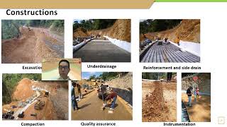
- DEM Analysis: Digital Elevation Models (DEMs) are crucial for generating slope, aspect, and curvature maps that help identify unstable zones prone to landslides. By examining these maps, civil engineers can assess which areas require further investigation or preventative measures.
- Time-Series Satellite Imagery: This technology enables monitoring of ground movement in landslide-prone regions by providing data over time, identifying changes that may indicate instability.
- Early Warning Systems: Using geoinformatics, baseline data can be collected and analyzed to establish alert systems for communities. This proactive approach informs residents of potential slope failures, allowing for timely evacuations or other mitigation actions.
Overall, these technologies collectively enhance the ability to monitor, assess, and respond to landslide risks, improving safety and preparedness in vulnerable areas.
Youtube Videos


Audio Book
Dive deep into the subject with an immersive audiobook experience.
DEM Analysis
Chapter 1 of 3
🔒 Unlock Audio Chapter
Sign up and enroll to access the full audio experience
Chapter Content
Slopemaps, aspect maps, and curvature maps generated from DEM help identify unstable zones.
Detailed Explanation
This chunk discusses how Digital Elevation Models (DEMs) are used in assessing slope stability. By generating various maps such as slope maps (which show the steepness of the terrain), aspect maps (indicating the direction the slope faces), and curvature maps (indicating the shape or curvature of the slope), engineers can pinpoint areas that are at risk of landslides. These models allow for a comprehensive analysis of the terrain's physical characteristics, which is crucial for understanding slope stability.
Examples & Analogies
Think of it like checking the balance of a stack of books. If the stack is too steep or if one book is placed at the wrong angle, it might fall over. Similarly, engineers use DEMs to check if the ground is stable or if certain areas are likely to slide down, preventing potential disasters.
Time-Series Satellite Imagery
Chapter 2 of 3
🔒 Unlock Audio Chapter
Sign up and enroll to access the full audio experience
Chapter Content
Used to monitor ground movement, especially in landslide-prone hilly regions.
Detailed Explanation
This chunk highlights the use of satellite images taken over different periods to track ground movements in areas that are prone to landslides. By analyzing these images, engineers can detect slight shifts in the terrain over time, which could indicate that a slope is destabilizing. This ongoing monitoring is vital for early detection and potential preventative measures before a landslide occurs.
Examples & Analogies
Imagine watching a time-lapse video of a tree growing. Just as you can see how much it changes over time, time-series satellite imagery allows engineers to observe ground movements gradually, highlighting any alarming shifts that could lead to a landslide.
Early Warning Systems
Chapter 3 of 3
🔒 Unlock Audio Chapter
Sign up and enroll to access the full audio experience
Chapter Content
Geo-Informatics provides baselined data for alert systems that inform communities in case of imminent slope failure.
Detailed Explanation
This final chunk addresses the role of Geo-Informatics in developing early warning systems. By utilizing the data collected from the aforementioned methods (DEM analysis and time-series imagery), communities can receive alerts if a slope is at risk of failure. This proactive approach helps in evacuating people from potential danger zones before a landslide occurs, enhancing public safety.
Examples & Analogies
It's similar to having a smoke detector in your house. Just like a smoke detector warns you of smoke before a fire can start, early warning systems use data to alert communities about potential landslides, allowing them to take action before disaster strikes.
Key Concepts
-
DEM Analysis: Utilizing Digital Elevation Models for slope stability assessment and landslide risk reduction.
-
Time-Series Imagery: Monitoring ground movement over time to identify potential landslide areas.
-
Early Warning Systems: Establishing alert mechanisms using geoinformatics data to protect communities.
Examples & Applications
Using DEMs to identify unstable slopes in hilly residential areas prone to landslides.
Implementing a time-series analysis of satellite data to predict landslides in regions affected by heavy rainfall.
Memory Aids
Interactive tools to help you remember key concepts
Rhymes
Slope maps help us see, where landslides might be free, data alerts we must not flee, safety comes with clarity!
Stories
Once in a village atop a hill, landslides were a permanent thrill. But with DEMs and alerts on the way, they learned to stay safe every day.
Memory Tools
Remember SLOPE: Steepness, Land cover, Observed landslides, Proximity to water, and Engineering methods for analyzing slope stability.
Acronyms
ALERT
Assess
Locate
Evaluate
Respond
Timely notification to remember early warning system components.
Flash Cards
Glossary
- Digital Elevation Model (DEM)
A 3D representation of terrain elevations, widely used in topographic mapping and geospatial analysis.
- Slope Map
A map that shows the steepness of a terrain, crucial for identifying prone areas to landslides.
- Aspect Map
A map illustrating the direction slopes face to help understand moisture and vegetation patterns.
- Curvature Map
A map that indicates the shape of the terrain and how water drains over it.
- TimeSeries Imagery
Satellite imagery taken over a period to monitor changes in the landscape and detect movements.
- Early Warning System
An alert system designed to notify communities of imminent risks, such as landslides, based on geospatial data.
- Slope Stability
The ability of a sloped surface to maintain its position and resist sliding or failure.
Reference links
Supplementary resources to enhance your learning experience.