
Recent Advances in Soil Compaction
Enroll to start learning
You’ve not yet enrolled in this course. Please enroll for free to listen to audio lessons, classroom podcasts and take practice test.
Interactive Audio Lesson
Listen to a student-teacher conversation explaining the topic in a relatable way.
Intelligent Compaction (IC)
🔒 Unlock Audio Lesson
Sign up and enroll to listen to this audio lesson

Let's talk about Intelligent Compaction, or IC. This technology uses GPS and sensors to monitor the density and stiffness of the soil in real-time during the compaction process. Why do you think real-time feedback might be advantageous?

It could help ensure we achieve the right density without overdoing it.
Exactly! It minimizes the need for repeated testing and allows for more efficient compaction operations. Can anyone remember what OMC stands for in relation to compaction?

Optimum Moisture Content!
Great! OMC is crucial for getting the maximum compaction density. So how might IC help in achieving this?

By adjusting the moisture content based on real-time feedback?
Correct! Good job, everyone. Real-time data helps optimize the moisture levels to achieve compaction goals.
Roller Integrated Compaction Monitoring (RICM)
🔒 Unlock Audio Lesson
Sign up and enroll to listen to this audio lesson

Now let's explore Roller Integrated Compaction Monitoring, or RICM. This technology uses embedded sensors in rollers to assess compaction quality. Why do you think this is a significant improvement over traditional methods?

Because it gives immediate insights while we are compacting instead of waiting for tests!
Exactly! It streamlines the process and helps operators make adjustments on the fly. What do you think could be the challenges with this technology?
Maybe calibration of the sensors?
That's right! Consistency in readings is crucial. How can we ensure that the data received is accurate?
Regular maintenance and calibration checks?
Perfect! Maintaining the technology is key to benefiting from it.
Drones in Soil Compaction Assessment
🔒 Unlock Audio Lesson
Sign up and enroll to listen to this audio lesson
Lastly, let’s discuss how drones are used in assessing soil compaction. They provide visual mapping for compaction coverage. Can anyone explain how this helps engineers?
It helps to see if there are any areas that are not compacted uniformly.
Exactly! Visual mapping enables quick identification of issues that can be addressed before it’s too late. Can someone define what uniformity in compaction means?
It means that the soil is compacted evenly throughout the area.
Right! Ensuring uniform compaction is critical for the stability and durability of structures. What might happen if certain areas are less compacted than others?
It could lead to uneven settlements or even structural failure!
Absolutely! That’s why these innovations are so important.
Introduction & Overview
Read summaries of the section's main ideas at different levels of detail.
Quick Overview
Standard
The recent advances in soil compaction focus on innovative technologies such as Intelligent Compaction (IC) that utilizes GPS and sensors for real-time monitoring, Roller Integrated Compaction Monitoring (RICM) for data-driven assessments, and drones for visual mapping of compaction effectiveness. These advancements optimize compaction processes and enhance quality control.
Detailed
Recent Advances in Soil Compaction
The field of soil compaction is rapidly evolving with the incorporation of modern technologies that promote efficiency and improve accuracy. This section introduces three significant advancements:
- Intelligent Compaction (IC): This technology integrates GPS and sensor systems to provide real-time monitoring of compaction density and stiffness during the process. By allowing operators to receive immediate feedback, it reduces the necessity for repeated field tests, leading to more effective compaction methods and better overall quality.
- Roller Integrated Compaction Monitoring (RICM): This involves embedding sensors into rollers used for compaction. These sensors collect and analyze data to evaluate compaction quality on-site while the machinery operates, making the compaction process more efficient and precise.
-
Use of Drones and Imaging: Drones are increasingly being utilized for visual mapping of compaction coverage across construction sites. This technology allows engineers to assess the uniformity of compaction effectively, ensuring that all areas meet the required standards.
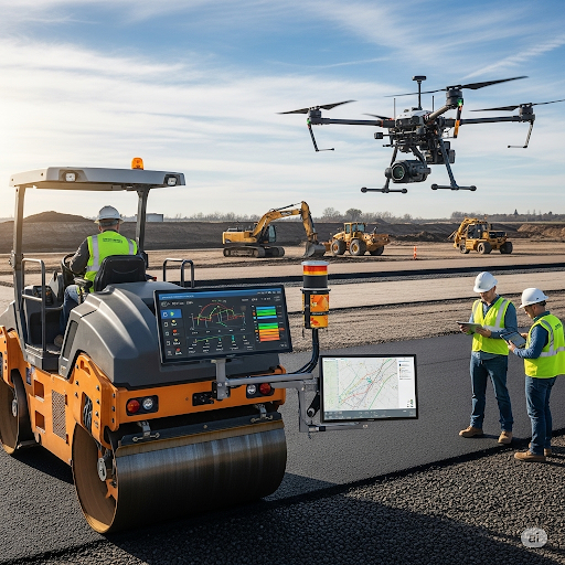
Overall, these innovations signify a shift towards automated, data-driven approaches that enhance soil compaction practices, ensuring the reliability and longevity of pavement structures.
Audio Book
Dive deep into the subject with an immersive audiobook experience.
Intelligent Compaction (IC)
Chapter 1 of 3
🔒 Unlock Audio Chapter
Sign up and enroll to access the full audio experience
Chapter Content
• Uses GPS and sensors to monitor real-time density and stiffness.
• Allows feedback-controlled compaction.
• Reduces need for repeated field testing.
Detailed Explanation
Intelligent Compaction (IC) is a cutting-edge method used in soil compaction. This technique employs GPS and sensors to continuously monitor the density and stiffness of the soil as it is being compacted. By providing real-time feedback, it enables operators to adjust their compaction efforts instantly. This means that less time and resources are wasted, as repeated field tests to check compaction are minimized.
Examples & Analogies
Imagine you are baking a cake. If you have a smart oven that not only tells you the temperature but also the cake's internal texture in real-time, you can adjust the heat as needed to ensure the perfect bake without opening the oven repeatedly. Similarly, Intelligent Compaction allows engineers to achieve optimal soil density without constant re-assessment.
Roller Integrated Compaction Monitoring (RICM)
Chapter 2 of 3
🔒 Unlock Audio Chapter
Sign up and enroll to access the full audio experience
Chapter Content
• Sensors embedded in rollers.
• Data analytics to assess compaction quality during operation.
Detailed Explanation
Roller Integrated Compaction Monitoring (RICM) involves placing sensors directly in the rollers used for compaction. These sensors gather data about the compaction quality while the roller is in operation. This analytics-driven approach allows for immediate insights into how well the soil is being compacted, ensuring that adjustments can be made on-the-spot to improve results.
Examples & Analogies
Think of a smart fitness tracker on your wrist. It measures your heart rate and provides feedback during your workout so that you can increase the intensity or slow down based on your performance. RICM does something similar for soil compaction, providing engineers with the necessary data to ensure optimal compaction as the work is being done.
Use of Drones and Imaging
Chapter 3 of 3
🔒 Unlock Audio Chapter
Sign up and enroll to access the full audio experience
Chapter Content
• Visual mapping of compaction coverage.
• Assessment of uniformity across the site.
Detailed Explanation
The utilization of drones and imaging technology for soil compaction allows for visual mapping of the compaction process. Drones can fly over the site to capture images that highlight where compaction has occurred and identify any areas that might have been missed. This technology helps engineers assess the uniformity of compaction across a site, ensuring that every part of the area meets the necessary standards.
Examples & Analogies
Think of drones like advanced photographers capturing the perfect scenic shots from above. Just as a photographer clicks images to ensure every detail is caught in the frame, drones help engineers visualize and ensure that every inch of the construction site is compacted properly, checking for consistency in their work.
Key Concepts
-
Intelligent Compaction: A method utilizing sensors for real-time monitoring of soil density.
-
Roller Integrated Compaction Monitoring: An integrated system measuring compaction parameters throughout the compaction process.
-
Drones for Compaction Assessment: Use of aerial technology for mapping and assessing soil compaction coverage.
Examples & Applications
An example of Intelligent Compaction is the use of GPS-enabled rollers at road construction sites to assess density continuously.
Drones can be employed to provide aerial visuals of a construction area to detect uneven compaction.
Memory Aids
Interactive tools to help you remember key concepts
Rhymes
In compaction, we trust, with sensors and data we must, IC and RICM lead the way, making compaction better each day.
Stories
Imagine a construction site where workers use GPS-equipped rollers. As they compact the soil, the sensors gather data, ensuring no area is left behind. A drone above collects visual evidence, showing their successful compaction.
Memory Tools
Remember IC for Intelligent Compaction, RICM for Roller Monitoring, and Drones for Data Visualization - ‘I Really Compacted Drones’!
Acronyms
IC - Intelligent Compaction, RICM - Roller Integrated Compaction Monitoring, Drones - Digital Resource Observers Near Engineering Sites.
Flash Cards
Glossary
- Intelligent Compaction (IC)
A compaction method that uses GPS and sensors to monitor density and stiffness in real-time.
- Roller Integrated Compaction Monitoring (RICM)
Technology that embeds sensors in compaction rollers to assess quality during the compaction process.
- Uniformity
The consistency of compaction across a site, crucial for structural integrity.
Reference links
Supplementary resources to enhance your learning experience.