
Computer-Aided Drafting (CAD) in Civil Engineering
Enroll to start learning
You’ve not yet enrolled in this course. Please enroll for free to listen to audio lessons, classroom podcasts and take practice test.
Interactive Audio Lesson
Listen to a student-teacher conversation explaining the topic in a relatable way.
Introduction to CAD Software
🔒 Unlock Audio Lesson
Sign up and enroll to listen to this audio lesson

Today we will talk about the popular CAD software utilized in civil engineering. Can anyone name a few?

Is AutoCAD one of them?
Yes, that's correct! AutoCAD is widely used. What about its main features?

It can do both 2D and 3D drafting!
Exactly! AutoCAD allows for multifunctional drafting. Besides AutoCAD, there's also Revit, known for Building Information Modeling. Remember, you can think of CAD as the 'CAD for creativity'! Any questions about Revit?
Coordinate Systems in CAD
🔒 Unlock Audio Lesson
Sign up and enroll to listen to this audio lesson

Now, let's discuss how to position objects in CAD using coordinates. There are three main coordinate systems: Absolute, Relative, and Polar. Can anyone summarize Absolute Coordinates?

They are based on a fixed point, the origin, right?
Correct! The format is X,Y based on the origin. How about the Relative Coordinate System?

That's when you specify distances from the last point using '@X,Y'?
Right again! And Polar Coordinates allow you to draw at an angle. Think of it as navigating with a compass. Great job, everyone!
Basic Drafting Commands
🔒 Unlock Audio Lesson
Sign up and enroll to listen to this audio lesson
Let's get into basic drafting commands! What do you think a LINE command does?
It draws straight lines.
That's right! And how would we draw a circle?
Using the CIRCLE command, specifying a center point and a radius!
Perfect! Remember: L for Line, C for Circle. Can anyone explain how to use the Trim command?
We select the parts we want to remove.
Absolutely, and Trim works to clean up our drawings. Keep practicing these commands!
Introduction & Overview
Read summaries of the section's main ideas at different levels of detail.
Quick Overview
Standard
Computer-Aided Drafting (CAD) has revolutionized the civil engineering field by improving design accuracy and efficiency. The section reviews popular CAD software like AutoCAD and Revit, fundamental drafting commands, and the importance of managing layers and dimensions, contributing to the overall design workflow in civil engineering.
Detailed
Computer-Aided Drafting (CAD) in Civil Engineering
Computer-Aided Drafting (CAD) has significantly impacted the Architecture, Engineering, and Construction (AEC) industries by streamlining the design and drafting processes. In civil engineering, CAD is instrumental in generating precise construction drawings for infrastructure projects such as buildings, roads, bridges, and water supply systems. This section delves into various aspects of CAD, covering:
- Popular CAD Software: Key software tools such as AutoCAD for 2D/3D drafting, Revit for Building Information Modeling (BIM), and others like STAAD.Pro and SketchUp.
- CAD Interface Overview: Description of essential components in AutoCAD's interface, including the Drawing Area, Command Line, and Ribbon.
- Coordinate Systems: Understanding Absolute, Relative, and Polar Coordinate Systems, which are crucial for accurately positioning objects in CAD.
- Basic Drafting Commands: Introduction to fundamental commands like LINE, CIRCLE, and RECTANGLE for basic shapes, along with Trim, Extend, Offset, and Mirror functions.
- Layer Management: Importance of layers in organizing drawings, managing visibility, color, and plotting order.
- Dimensioning and Annotation: Types of dimensions and effective dimension style management to ensure clarity in drawings.
- Blocks and Hatching: Creating reusable symbols and representing materials through hatching in CAD drawings.
- Building Plans: Necessary components and procedural steps in drawing building plans using CAD.
- 3D Drafting and Isometric Views: Tools for creating 3D models and the significance of isometric drawing in representing complex structures.
- Plotting and Printing: Key plot settings and the functionality of viewports for preparing drawings for printing.
- Best Practices: Maintaining standards in CAD drafting to ensure professional and efficient workflows.
Youtube Videos


Audio Book
Dive deep into the subject with an immersive audiobook experience.
Introduction to CAD in Civil Engineering
Chapter 1 of 12
🔒 Unlock Audio Chapter
Sign up and enroll to access the full audio experience
Chapter Content
Computer-Aided Drafting (CAD) has transformed the architecture, engineering, and construction (AEC) industries by enhancing the speed, accuracy, and efficiency of design and drafting processes. In civil engineering, CAD plays a pivotal role in producing precise construction drawings for buildings, roads, bridges, water supply systems, and other infrastructure projects. It replaces traditional manual drafting tools with software-based design, making it easier to create, modify, optimize, and share detailed plans in both 2D and 3D formats.
Detailed Explanation
This introduction highlights how CAD has revolutionized civil engineering by increasing the efficiency and precision of design work. CAD software allows engineers to easily create and modify plans for various infrastructure developments, which is a significant improvement over older, manual drafting methods that were more time-consuming and prone to errors.
Examples & Analogies
Imagine an artist who can only paint with traditional brushes and colors. This might take a long time, and any mistakes can mean starting over. Now, picture an artist using digital software that lets them easily adjust colors, undo mistakes, and add enhancements quickly. That's how CAD changes the game for civil engineers, letting them create accurate blueprints that can be rapidly adjusted.
Popular CAD Software in Civil Engineering
Chapter 2 of 12
🔒 Unlock Audio Chapter
Sign up and enroll to access the full audio experience
Chapter Content
- AutoCAD: Widely used for 2D and 3D drafting and detailing.
- Revit: Focused on Building Information Modeling (BIM).
- STAAD.Pro / ETABS: Primarily for structural analysis but integrate with CAD.
- SketchUp: For conceptual 3D modeling.
AutoCAD remains the standard for most educational and professional use in civil drafting due to its comprehensive toolset and ease of use.
Detailed Explanation
This chunk discusses the most common CAD software used in civil engineering. AutoCAD is highlighted as a leading tool for both educational and professional applications, owing to its wide range of features for 2D and 3D drafting. Other software like Revit, STAAD.Pro, and SketchUp are mentioned for their specific uses, like structural analysis and conceptual modeling.
Examples & Analogies
Think of CAD software like different types of musical instruments. Just as a pianist would use a piano for melodic pieces but might use a guitar for different styles, civil engineers choose software based on the task at hand—AutoCAD for detailed drafting, Revit for building modeling, and so on.
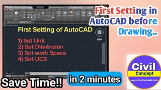
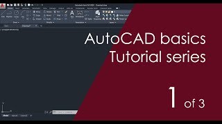
Interface of AutoCAD
Chapter 3 of 12
🔒 Unlock Audio Chapter
Sign up and enroll to access the full audio experience
Chapter Content
- Drawing Area: Main workspace where drawings are created.
- Command Line: Used to enter commands directly.
- Ribbon/Toolbar: Contains tools grouped by function.
- Model/Layout Tabs: Switch between model space and paper space.
- Status Bar: Displays cursor coordinates, grid, snap, ortho mode, etc.
Detailed Explanation
This chunk outlines the main components of the AutoCAD interface. Each part serves a specific purpose: the Drawing Area is where you create designs, the Command Line lets you input commands, and the Ribbon organizes tools by function. The Model/Layout Tabs help you navigate between different views of your drawing, while the Status Bar provides helpful information regarding your current settings.
Examples & Analogies
Consider the AutoCAD interface like the dashboard of a car. Just as a driver uses a dashboard to check speed, fuel, and other essential indicators, CAD users rely on the various components of the interface to manage their drawing environment efficiently.
Coordinate Systems in CAD
Chapter 4 of 12
🔒 Unlock Audio Chapter
Sign up and enroll to access the full audio experience
Chapter Content
14.2.1 Absolute Coordinate System: Coordinates are entered with reference to the origin (0,0). Format: X,Y
14.2.2 Relative Coordinate System: Coordinates are entered with reference to the last point. Format: @X,Y
14.2.3 Polar Coordinates: Used for angular input, ideal for inclined lines. Format: @distance
Detailed Explanation
This section describes three different coordinate systems used in CAD. The Absolute Coordinate System uses a fixed origin point for reference, making it straightforward to locate points. The Relative Coordinate System helps manually reference the last point you worked on, creating a more dynamic drafting experience. Lastly, Polar Coordinates allow for the drafting of lines at specific angles, beneficial for inclined structures.
Examples & Analogies
Imagine you are on a treasure hunt. The absolute coordinates are the map's fixed landmarks, while the relative coordinates are the directions you take from your last position. Polar coordinates are akin to adjusting your compass to find a treasure at a specific angle from your current location.
Basic Drafting Commands
Chapter 5 of 12
🔒 Unlock Audio Chapter
Sign up and enroll to access the full audio experience
Chapter Content
14.3.1 Line Command: Draws straight lines between two points.
Command: LINE
Specify first point: 0,0
Specify next point: 100,0
14.3.2 Circle Command: Draws circles using center and radius/diameter.
Command: CIRCLE
Specify center point: 50,50
Specify radius: 10
14.3.3 Rectangle Command: Draws rectangles by specifying two opposite corners.
Command: RECTANGLE
Specify first corner: 0,0
Specify opposite corner: 100,50
14.3.4 Trim and Extend: Trim removes unwanted parts of objects, and Extend lengthens an object to meet another boundary.
14.3.5 Offset and Mirror: Offset creates parallel lines or curves at a specified distance, while Mirror creates a mirrored copy about a defined axis.
Detailed Explanation
This section introduces essential CAD commands for drafting. The Line Command allows users to draw straight lines by specifying two points. The Circle Command utilizes a center point and radius to create circles, and the Rectangle Command draws rectangles using two corners. Additionally, the Trim and Extend commands modify existing shapes, while the Offset and Mirror commands help in creating duplicate or parallel elements in a design.
Examples & Analogies
Think of these drafting commands like the basic tools in a craft toolbox. Just as you would use a ruler to draw straight lines, a compass for circles, and a square for rectangles, CAD commands offer similar foundational tools for creating drawings efficiently.
Layers and Object Properties
Chapter 6 of 12
🔒 Unlock Audio Chapter
Sign up and enroll to access the full audio experience
Chapter Content
14.4.1 Importance of Layers: Layers organize the drawing by separating different elements (walls, furniture, doors, plumbing, etc.). They help in visibility control, color management, line type management, and plotting order.
14.4.2 Creating and Managing Layers: Use LAYER command. Assign colors, line types, and line weights. Lock/Unlock layers as needed. Example: Layer 1: Walls – red – continuous; Layer 2: Doors – blue – dashed.
Detailed Explanation
Layers are vital for organizing various elements within a drawing. This structure allows for easy visibility control and management of different drawing properties, enabling designers to work more efficiently. The LAYER command helps create and manage layers, where elements can be uniquely identified by colors and line types.
Examples & Analogies
Think of layers in CAD like layers of clothing. Just as you wear different clothes for different occasions (like formal wear for a conference versus casual wear for a picnic), layers in a CAD drawing allow you to organize distinct features of a project, helping you focus on one aspect without distraction from others.
Dimensioning and Annotation
Chapter 7 of 12
🔒 Unlock Audio Chapter
Sign up and enroll to access the full audio experience
Chapter Content
14.5.1 Types of Dimensions: Linear (horizontal, vertical), Aligned, Angular, Radius, and Diameter.
14.5.2 Dimension Style Management: DIMSTYLE command allows customization of text size, arrow type, and units.
14.5.3 Text Annotation: TEXT and MTEXT are used for adding notes and labels to drawings. Font type and size should be readable and consistent.
Detailed Explanation
This chunk focuses on dimensioning and annotation, which are crucial for providing measurements and notes on drawings. Different types of dimensions—linear, aligned, angular, radius, and diameter—ensure that every detail is communicated accurately. The DIMSTYLE command allows customization of how these dimensions appear, while TEXT and MTEXT commands add descriptive notes to your drawings.
Examples & Analogies
Imagine sending a postcard. The dimensions are like the information about where the postcard should be sent—without clear dimensions (like the address), the postcard may not arrive at the right place. Similarly, dimensioning in CAD ensures all parts of a drawing are accurately represented so they can be understood and constructed without confusion.
Blocks and Hatching
Chapter 8 of 12
🔒 Unlock Audio Chapter
Sign up and enroll to access the full audio experience
Chapter Content
14.6.1 Blocks: Blocks are reusable symbols or drawing elements (e.g., windows, doors, fixtures). Created using BLOCK or WBLOCK; inserted using INSERT command. Benefits include reducing file size, improving consistency, and speeding up drafting.
14.6.2 Hatching: Used to represent materials (brick, concrete, etc.) in section views. Command: HATCH; Patterns include ANSI31, SOLID, BRICK, etc.; Adjust scale and angle for clarity.
Detailed Explanation
This section discusses blocks and hatching, which enhance the efficiency of CAD drafts. Blocks are predefined symbols that can be reused throughout projects, saving time and ensuring design consistency. Hatching fills areas within drawings to indicate different materials, making it easier to visualize designs in section views.
Examples & Analogies
Think of blocks like cookie cutters. Once you have a shape cut out, you can use that same shape over and over without having to reshape the dough each time. Similarly, blocks in CAD allow engineers to insert standard symbols efficiently. Hatching can be likened to coloring in a coloring book—using specific patterns to fill in areas to indicate different materials.
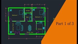
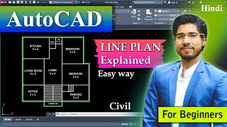
Drawing Building Plans Using CAD
Chapter 9 of 12
🔒 Unlock Audio Chapter
Sign up and enroll to access the full audio experience
Chapter Content
14.7.1 Plan Components: Site plan, Floor plan, Section and elevation, Door and window schedule, Foundation plan.
14.7.2 Drawing Procedure (Example: Residential Building): 1. Draw plot boundary. 2. Draw wall layout with layers. 3. Insert blocks for doors, windows, sanitary fixtures. 4. Add dimensions and labels. 5. Apply hatching for materials. 6. Create elevation and section from plan. 7. Use layout for plotting to scale.
Detailed Explanation
This section explains the various components of drawing building plans and the step-by-step procedure for creating a residential building design. Key components include the site plan and floor plan, which represent different aspects of the building. The procedure outlines essential actions, such as defining boundaries, drawing walls, and laying out fixtures and materials, forming a complete building plan.
Examples & Analogies
Drawing a building plan is like putting together a puzzle. You start with the edges (plot boundary), and gradually fill it in with different pieces (walls, doors, dimensions) to create a complete picture. Each step is crucial to ensuring the final image—the building—is accurate and functional.
3D Drafting and Isometric Views
Chapter 10 of 12
🔒 Unlock Audio Chapter
Sign up and enroll to access the full audio experience
Chapter Content
Although civil engineers primarily use 2D drawings, 3D drafting is increasingly common. 14.8.1 3D Tools in AutoCAD: Extrude, Revolve, Sweep, Presspull. 14.8.2 Isometric Drawing: Used for pipelines, plumbing, and architectural presentation. Switch to isometric grid: ISODRAFT; Use ELLIPSE with isocircle option for pipes.
Detailed Explanation
This chunk highlights the growing use of 3D drafting in civil engineering. While 2D drawings remain the standard, tools like Extrude, Revolve, Sweep, and Presspull allow engineers to create three-dimensional models. Isometric drawing techniques help visualize elements like pipes and other cylindrical features that require a more realistic representation.
Examples & Analogies
Think of moving from a 2D sketch of a car to a full 3D model. Just as a 3D model allows you to see all angles and features of a car, 3D drafting in CAD offers engineers a comprehensive view of their designs, helping them to better analyze and present their projects.
Plotting and Printing Drawings
Chapter 11 of 12
🔒 Unlock Audio Chapter
Sign up and enroll to access the full audio experience
Chapter Content
14.9.1 Plot Settings: Paper size (A4, A3, A1, etc.), Plot area: Window or Layout, Plot scale: 1:100, 1:50 etc., Plot style table: Monochrome or color. 14.9.2 Viewports in Layout: Used to display multiple views at different scales in paper space. 14.9.3 Title Block and Border: Add standardized title blocks (can be a block); Include drawing title, name, scale, date, sheet number.
Detailed Explanation
This section covers the important aspects of plotting and printing CAD drawings. Proper plot settings ensure that the drawings are printed accurately, fitting the desired paper size and scale. Viewports allow for the display of multiple perspectives of the drawing, while title blocks provide essential information about the project and can be standardized for consistency.
Examples & Analogies
Consider plotting like preparing a recipe for a meal. You have specific ingredients (drawings) that need to be presented on the right plate (paper size) in the correct serving size (scale). Just like a well-prepared meal includes all the essential garnishes (title blocks), effective plotting ensures that every drawing has the necessary details for clarity.
Best Practices in CAD Drafting
Chapter 12 of 12
🔒 Unlock Audio Chapter
Sign up and enroll to access the full audio experience
Chapter Content
- Maintain layer standards and use naming conventions.
- Use blocks to reduce redundancy.
- Annotate with clarity and standard text size.
- Regularly save and back up files.
- Use external references (Xrefs) for large projects.
- Maintain drawing units and scale consistency.
Detailed Explanation
This concluding section provides best practices that are essential for effective CAD drafting. Maintaining layer standards ensures that drawings remain organized, while using blocks minimizes repetition. Clarity in annotations is crucial for understanding, and regular file backups prevent data loss. Using external references is particularly helpful for larger projects where organization becomes critical.
Examples & Analogies
Think of best practices like a set of rules for playing a team sport. Just as players follow strategies to ensure teamwork and success on the field, following best practices in CAD helps ensure that designs are clear, organized, and free of errors, leading to successful project outcomes.
Key Concepts
-
CAD: Essential software for drafting in engineering.
-
Coordinate Systems: Different methods for specifying points in CAD.
-
Layers: Organization tools to manage drawing elements effectively.
-
Basic Commands: Fundamental commands to create and edit drawings.
Examples & Applications
Using the LINE command, a civil engineer can draw walls for a building layout.
Applying the CIRCLE command to design a circular pond on a site plan.
Memory Aids
Interactive tools to help you remember key concepts
Rhymes
In CAD we create, layers we rate, to keep it all neat, and never too straight.
Stories
Imagine a builder named CAD who organized his tools in layers; it made drafting a breeze, and he finished projects with ease!
Memory Tools
To remember the three coordinate systems: "A Really Pleased Cat" stands for Absolute, Relative, Polar.
Acronyms
RAP
Remember Absolute and Relative Coordinates/Ploar representation.
Flash Cards
Glossary
- CAD
Computer-Aided Drafting; software used for creating precise drawings and designs.
- Absolute Coordinate System
A coordinate system where points are specified in relation to a fixed origin.
- Relative Coordinate System
A coordinate system where points are defined relative to the last specified point.
- Polar Coordinates
Coordinates defined by distance and angle from a reference point.
- Layers
Divisions in a drawing that organize different elements for clarity and management.
- Blocks
Reusablesymbols or drawing elements for common objects.
- Hatching
A method of shading or filling areas in a drawing to represent different materials.
- Dimensioning
Adding measurements to drawings to indicate size and location.
Reference links
Supplementary resources to enhance your learning experience.