
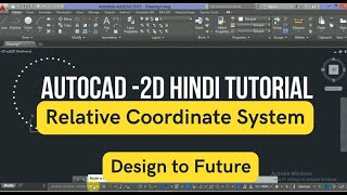
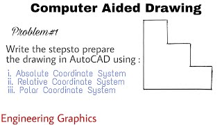
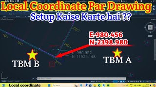
Relative Coordinate System
Enroll to start learning
You’ve not yet enrolled in this course. Please enroll for free to listen to audio lessons, classroom podcasts and take practice test.
Interactive Audio Lesson
Listen to a student-teacher conversation explaining the topic in a relatable way.
Introduction to Relative Coordinate System
🔒 Unlock Audio Lesson
Sign up and enroll to listen to this audio lesson

Today, we are going to discuss the Relative Coordinate System in CAD. Can anyone tell me what a relative coordinate is?

Is it when you define a point based on the last point you drew?
Exactly! In the Relative Coordinate System, you use coordinates in relation to the last defined point. Instead of starting from the origin, you can move from wherever you last placed a point.

How do we format those coordinates?
Great question! You format them as '@X,Y'. For instance, '@3,4' would mean move 3 units in the x-direction and 4 units up from the last point.
Benefits of Using Relative Coordinates
🔒 Unlock Audio Lesson
Sign up and enroll to listen to this audio lesson

Now, let’s talk about the benefits of using Relative Coordinates. Why do you think it’s advantageous?

It must be faster than calculating absolute positions each time!
Exactly! It allows for a quicker and more flexible drafting process, making it easier to create intricate designs. Can anyone think of a situation where this would be particularly useful?

Maybe when creating a complex shape that doesn't have straight lines?
Precisely! Using relative coordinates allows you to easily draw shapes that change direction without needing to realign your origin constantly.
Practical Application of Relative Coordinates
🔒 Unlock Audio Lesson
Sign up and enroll to listen to this audio lesson
Let’s try applying what we’ve learned. If we start at point 0,0 and move to @5,10, where do we end up?
That would put us at point 5,10?
Correct! Now, if we go from there to @-3,-2, where are we now?
That should be at point 2,8.
Great work! This shows how you can continuously move around the drawing without resetting your point of reference.
Introduction & Overview
Read summaries of the section's main ideas at different levels of detail.
Quick Overview
Standard
In the Relative Coordinate System, points are defined in relation to the previous point specified in the drawing, using the format '@X,Y'. This method simplifies the drafting process, allowing users to efficiently create complex shapes without recalculating absolute positions.
Detailed
In-depth Summary
The Relative Coordinate System is a critical method in CAD software that enables users to enter coordinates relative to the last specified point. This is particularly useful in streamlining the drafting process by removing the need to constantly reference the main origin (0,0) points. The coordinates are entered using the '@' symbol followed by the relative x and y values, for example, '@5,10' would denote moving 5 units in the x-direction and 10 units in the y-direction from the last point. This system not only speeds up the drafting process but also significantly reduces errors associated with manual recalculations of absolute positions, making it an essential tool for civil engineers and drafters alike.
Youtube Videos


Audio Book
Dive deep into the subject with an immersive audiobook experience.
Definition of Relative Coordinates
Chapter 1 of 2
🔒 Unlock Audio Chapter
Sign up and enroll to access the full audio experience
Chapter Content
Coordinates are entered with reference to the last point.
- Format: @X,Y
Detailed Explanation
The relative coordinate system allows users to specify coordinates based on the last point they created on the drawing. So instead of providing absolute values from the origin (0,0), you just tell the software how far to move from the last point. For example, if your last point was at (100, 50) and you want to draw a line to a new point that is 20 units to the right and 10 units up, you'd enter @20,10. This is simpler and faster than calculating the absolute coordinates.
Examples & Analogies
Think of it like moving from one spot in a room to another. If you're standing next to a table and you want to walk to a chair nearby, you might say, 'move to the right 2 steps and forward 1 step' instead of counting your distance from a fixed point in the room. This way, you can quickly describe your new position relative to where you are.
Benefits of Using Relative Coordinates
Chapter 2 of 2
🔒 Unlock Audio Chapter
Sign up and enroll to access the full audio experience
Chapter Content
Relative coordinates streamline the drafting process by limiting the amount of detailed measurement and allowing more intuitive movement within the drawing.
Detailed Explanation
Using relative coordinates can significantly enhance efficiency in drafting. It reduces the cognitive load on the user because you only need to think about how far to move from your last drawing point rather than resetting your perspective to the original coordinate system constantly. This can be particularly useful in complex drawings where moving in small increments is common.
Examples & Analogies
Imagine you're doing a puzzle on a table. Instead of always measuring the distance from the edge of the table (which represents absolute coordinates), you simply say, 'move this piece from where I just placed it.' This way, you stay focused on what you’re doing without stopping to figure out how far you have to go from the corner of the table each time.
Key Concepts
-
Relative Coordinate System: A system for defining points in CAD based on the last specified location.
-
Use of '@': Denotes relative movement in the coordinate input.
Examples & Applications
For a drawing where you need to create a shape that bends left and right, using relative coordinates allows you to quickly change directions without resetting your starting point.
If a line starts from point (5,5) and you then input '@3,2', the new point will be at (8,7) without reference to the original origin.
Memory Aids
Interactive tools to help you remember key concepts
Rhymes
Relative coordinates are a clever trick, moving from last point makes drafting quick!
Stories
Imagine a treasure map where each step takes you not from the start but from where you last stood, finding your path one step at a time.
Memory Tools
Remember: '@' tells you 'away from last'. Think 'A' for 'Away'!
Acronyms
RCS can stand for 'Relative Coordinate System', reminding us we move from the Last Point!
Flash Cards
Glossary
- Relative Coordinate System
A system where coordinates are defined relative to the last specified point using the format '@X,Y'.
- Coordinate
A set of values that define the position of a point in a particular coordinate system.
Reference links
Supplementary resources to enhance your learning experience.