
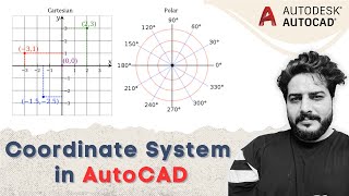
Coordinate Systems in CAD
Enroll to start learning
You’ve not yet enrolled in this course. Please enroll for free to listen to audio lessons, classroom podcasts and take practice test.
Interactive Audio Lesson
Listen to a student-teacher conversation explaining the topic in a relatable way.
Absolute Coordinate System
🔒 Unlock Audio Lesson
Sign up and enroll to listen to this audio lesson

Welcome everyone! Today, we're starting with the absolute coordinate system in CAD. Can anyone tell me what absolute coordinates are?

Isn't it when you start measurements from a fixed point, like the origin?
Exactly right! Absolute coordinates use a fixed origin point designated as (0,0). You express them in the format of X,Y. Why do you think this is important in drafting?

Because it ensures that everything is precisely located relative to a known point!
Exactly! Having a reference point makes it easier to create precise designs. Let's remember this with the acronym 'A' for Absolute = 'A' for Accurate! Does that help?

Yes, that’s a good way to remember it!
Relative Coordinate System
🔒 Unlock Audio Lesson
Sign up and enroll to listen to this audio lesson

Now let’s move on to the relative coordinate system. Who can explain how this one works?

Is it based on the last point you clicked or drew?
Correct! The format is `@X,Y`, where the `@` indicates that the coordinates relate to the last point. How might this be useful?
It allows for faster drawing since you don't need to reference the origin every time.
Exactly! Using relative coordinates speeds up the drafting process significantly. Let’s remember this with 'R' for Relative = 'R' for Rapid!
Polar Coordinate System
🔒 Unlock Audio Lesson
Sign up and enroll to listen to this audio lesson
Last, let’s explore polar coordinates. Who can explain what they are?
They use angles, right? Like for drawing circles or inclined lines?
Exactly! Polar coordinates are written as `@distance<angle`. Can anyone give me an example of when you’d use them?
When creating sloping roofs or circular paths!
Exactly! Don’t forget, ‘P’ for Polar = ‘P’ for Perspective! Perspectives in angles matter in design. Any questions?
Introduction & Overview
Read summaries of the section's main ideas at different levels of detail.
Quick Overview
Standard
In this section, we explore the fundamental coordinate systems utilized in CAD: absolute coordinates, which reference a fixed origin; relative coordinates, referencing the last point used; and polar coordinates, which involve angular measurements. Understanding these systems is crucial for effective drafting and design.
Detailed
Coordinate Systems in CAD
Computer-Aided Drafting (CAD) employs coordinate systems that provide the framework for drawing and modeling in two and three dimensions. This section discusses three primary types of coordinate systems:
1. Absolute Coordinate System
- Definition: Coordinates are provided with reference to a fixed origin point, typically noted as (0,0).
- Format: The coordinates are formatted as
X,Y, whereXis the horizontal position andYis the vertical position.
2. Relative Coordinate System
- Definition: This system allows users to input coordinates based on the last specified point, offering flexibility and efficiency in drawing.
- Format: The format used is
@X,Y, where the@symbol indicates that the entered coordinates are relative to the last point drawn.
3. Polar Coordinate System
- Definition: Suitable for angular inputs, especially when creating inclined lines, the polar coordinate system combines distance and angle.
- Format: This is noted as `@distance
Youtube Videos


Audio Book
Dive deep into the subject with an immersive audiobook experience.
Absolute Coordinate System
Chapter 1 of 3
🔒 Unlock Audio Chapter
Sign up and enroll to access the full audio experience
Chapter Content
- Absolute Coordinate System
Coordinates are entered with reference to the origin (0,0). - Format: X,Y
Detailed Explanation
The Absolute Coordinate System allows users to define points in a CAD drawing based on a fixed origin point, which is marked as (0,0). When entering coordinates, you specify the exact location using the format X,Y, where X represents the horizontal distance from the origin and Y represents the vertical distance. For example, entering (5,3) places a point 5 units to the right and 3 units up from the origin.
Examples & Analogies
Imagine you're in a large park, and you want to describe the location of a specific tree. If you have a map with a marked starting point (the park entrance) as (0,0), you could say the tree is located at coordinates (5,3), which means you walk 5 meters east and 3 meters north from the entrance to find it.
Relative Coordinate System
Chapter 2 of 3
🔒 Unlock Audio Chapter
Sign up and enroll to access the full audio experience
Chapter Content
- Relative Coordinate System
Coordinates are entered with reference to the last point. - Format: @X,Y
Detailed Explanation
The Relative Coordinate System helps users define points based on the last point they created. Instead of giving absolute coordinates, you would use '@X,Y', which tells the CAD system to calculate the new point's position relative to the previous one. For instance, if the last point was (5,3) and you enter @2,1, the new point will be at (7,4).
Examples & Analogies
Think of it like following directions from a particular spot rather than always from the starting point. If you were at a restaurant and your friend said to walk 2 steps forward and then 1 step to the right, you’re not measuring from some other landmark but from where you are right now.
Polar Coordinates
Chapter 3 of 3
🔒 Unlock Audio Chapter
Sign up and enroll to access the full audio experience
Chapter Content
- Polar Coordinates
Used for angular input, ideal for inclined lines. - Format: @distance
Detailed Explanation
Polar Coordinates allow you to specify points using a distance and an angle, which is especially useful for drawing lines that are at an angle rather than straight along the axes. The format @distance
Examples & Analogies
Imagine you're playing darts. When you aim for a target at an angle (say, 30 degrees) and throw the dart a certain distance (like 5 meters), the position of the dart is defined by both how far and in what direction you aimed. Similarly, polar coordinates help you define positions based on distance and angle.
Key Concepts
-
Absolute Coordinate System: A fixed reference point for precision.
-
Relative Coordinate System: An efficient method referencing the last point.
-
Polar Coordinate System: Combines distance and angle for inclined drawing.
Examples & Applications
In an architectural plan, absolute coordinates might place the front entrance at (10,15) from the origin.
Using relative coordinates, if the last point drawn was at (10,15), specifying @5,0 would place the next point at (15,15).
Drawing a ramp at a 30-degree incline can be achieved using the polar coordinates format of @5<30.
Memory Aids
Interactive tools to help you remember key concepts
Rhymes
In CAD with lines so neat, absolute’s where you start your seat.
Stories
Imagine sketching a house. You start at the front door (0,0); that's absolute. When drawing the driveway, you see the last point and measure from there; that's relative! For the roof's slope, think of an angle at a distance; that's polar!
Memory Tools
A.R.P.: Absolute, Relative, Polar — the order of how you can measure points.
Acronyms
Remember A.R.P. for coordinates in CAD
Absolute
Relative
Polar.
Flash Cards
Glossary
- Absolute Coordinate System
A coordinate system where points are determined based on a fixed origin, noted as (0,0).
- Relative Coordinate System
A system that defines coordinates with reference to the last point specified, typically using the format @X,Y.
- Polar Coordinate System
A coordinate system that uses distance and angle to define points, formatted as @distance
Reference links
Supplementary resources to enhance your learning experience.